Sunday, October 14, 2012

Back home to Texas

We've been at home for a few days now, completely buried with mowing, unpacking, catching up on mail, and all the other bits related to settling back in to a different routine than we've had for the last few months.

Before we close out the travel reports for the season I have to report on the two stops we made in Texas on our way home. I know every state has "history" and something interesting has happened at some point everywhere you go, but sometimes you really have to dig to find out what that history is. In Texas it's usually easy, as the state and residents are so proud of their history that there are signs and monuments everywhere. Our first stop once we crossed the Oklahoma/Texas state line is a perfect example.

Collingsworth Pioneer Park, is an unexpected gem along the highway.
It's a beautiful, grassy park, campground, and rest stop just north of Wellington.

The friendly hosts will proudly tell you about the Bonnie and Clyde's Red River Plunge. The old bridge abutment off which they plunged was only two spaces down from our site.
part of the old bridge to right of tree
A small sign at the entrance to the park describes the event now, but a much larger history information kiosk is currently under construction. It will have more detail about the event, which was the typical Bonnie and Clyde shooting and mayhem, and will include other information about the region when it's finished.

Shiner very much enjoyed the huge expanse of grass here, and the hosts are very "dog friendly" too. They even warned us about where NOT to go along the river to avoid the nasty burr grass.

Swimming pool
We headed out fairly early for what would be our last night on the road, Abilene State Park State Park, near Buffalo Gap, I just love the name! Only a few miles from the big city of Abilene, this makes a great central location for exploring what is a very historic area.  At the time of the Civil War, huge herds of buffalo roamed this area. A favorite buffalo run was through the gap in the Callahan Divide, near what is now the town of Buffalo Gap (pop. 464).

Lake Abilene was originally intended as a water source for the town, but in the way of all Texas lakes, it dried up at one point, so rather than relying on it for that purpose it became a focal point for recreation and wildlife. The fishing's great I hear!

The park has several CCC buildings which have been perfectly maintained, and there are several trails to wander, along the creeks and fishing holes.

 They'd had rain here so the wildflowers were starting to come back with an almost spring-like effect.

We were assigned a space in the Wagon Wheel RV circle..... odd parking arrangement. You back your rig in to what would be the hub of a wagon wheel. It works fine for rigs shorter than ours, or if you unhitch, which we didn't want to do. And, the power and water for two adjacent sites is located on one spot, so it ends up being on the "wrong" side for half of the rigs. Fortunately it wasn't at all crowded so we were able to make-do.
Scenes from Abilene State Park


That particular part of the park is the only option if one wants clear skies for any kind of satellite reception. There are other areas set up for RVs but they are in dense forest.

We were home by early afternoon, and began the gear-shifting to "ranch" mode. We'll continue to write about local travels, RV related products, and any improvements we make, so stay tuned!


Tuesday, October 9, 2012

We're not in Kansas anymore!

We left Buffalo Bill State Park shortly before 10 AM under a cold, gray and cloudy sky. By 11:00 AM we were in McCook, in SW Nebraska, and admiring the gently falling snow. It wasn't exactly a blizzard, but there was enough to make the roof-tops and ground white and more drifting down, a chilly 35 degrees, but thankfully no wind!

The rolling grain fields of Nebraska flattened considerably once we entered Kansas, looking more the way we've pictured the plains, and the snow stopped! No doubt because it had warmed up to 36!

You never know what unique sites you'll encounter on the road. We stopped for fuel and while it was pumping watched this semi tow a wind turbine tower around a sharp corner. You've got to admire the skill some of these truck drivers demonstrate in managing large loads like this one.There are a few of these wind generators on the horizon across the plains, but so far none of the huge installations that we've seen in Texas and California.

 We later crossed over a rail line with a multitude of cars carrying these tubes, and passed truck after truck transporting them. Apparently this is a booming business in the area.

We skirted around the west side of Oakley, the county seat of Logan County. Oakley wasn't named for the world-famous performer "Annie", the town-site was laid out by David Hoag in 1884 and named after his mother, Elizabeth Oakley Gardner-Hoag. Annie Oakley did performed with the "Wild West Show" in the area.
There's a museum honoring Buffalo Bill at the entrance to town, and nearby is this amazing sculpture of Buffalo Bill in action. It commemorates a buffalo shooting contest near the town between William Cody and William Comstock. Cody won, earning the name "Buffalo Bill".

The seemingly flat terrain across Kansas is deceptive. As we left the highway for our new temporary home at
Our site, looking toward Horsethief Canyon
Scott Lake State Park we suddenly found ourselves in a deep canyon filled with rocky cliffs and a wide variety of hardwood and evergreen trees.
Scott Lake is primarily a fishing lake, but there are also accommodations for equestrians, and judging by the concession stands around the lake shore it must be a very popular family hangout during the summer. Everything is closed this time of year. In fact, we never saw any park personnel, and only a handful of other campers.

An unusual feature of the park is an archeological site - Pueblo Indian ruins. Pueblo tribes are generally considered to live in the southwest, but on two occasions two different groups ventured clear up here, stayed only briefly, then returned to their homelands. Several signboards around he excavation explain the history of the area.


There's also an historic home, once belonging to the couple that donated this property for use as a park.
It was not open, closed for the season as is everything else, but looked quite cozy tucked in a copse of trees near one of the limestone cliffs. High up on top of the cliff is a monument to the family, and a stone shelter for those ambitious enough to climb up the narrow trail to view the monument.

There are vague trails up the rocky canyons here, making for interesting walking, but cutting cross-country is a bit hazardous. It seems a strange combination, but the forest of trees is carpeted with sharp, spiny yucca and cactus.
Do I look cold enough?
Venturing off the trail is hazardous to one's shins!  The multiple blossom stem remaining from the yucca that bloomed in the spring illustrates just how many of them there are.

Under other circumstances the trail would have been of interest to me, us but with the 34 degree day and intermittent snow showers  a quick view of the archeological site was about all we could muster up. We made a quick tour of the site and then dove back into the RV for a nice, comfy day watching football.

Just before we left the state we stopped for fuel in Liberal, Kansas, home of Dorthy and Toto. Their house was just down the Yellow Brick Road from the fuel station! (That really is the name of the street!)

A few miles down the road we left Kansas and enter Oklahoma. Across the narrow panhandle we saw extensive oil and natural gas wells, cattle, and lots of wide open spaces. By evening we were in The Republic, at our overnight stop, Collingsworth Pioneer Park, near Wellington. See the next post for a report on that site.

Friday, October 5, 2012

Nebraska

From Laramie's 8,000+ altitude we rolled downhill into Nebraska, aided by a stiff tailwind - that little assist doubled our mileage so we didn't complain!

On the recommendation of a friend we scheduled my birthday lunch stop at Ole's Big Game Steakhouse in the little village of Paxton, just off I-80 (pop. 614). Thanks for the recommendation Evie, it was a great experience!!!
 The restaurant was founded in 1933, the year Prohibition ended in Nebraska. Founder Rosser O. Herstedt, "Ole", loved to travel the world and hunt wild game, and over the years his trophies and photos of his adventures accumulated on the walls of the restaurant until now there's hardly a square foot of wall without some sort of adornment.

The beautiful old wooden bar-back is so covered with brewery and distillery cmemorabelia that you can hardly see the carved columns. Fascinating to say the least!

We enjoyed delicious hamburgers and an excellent brew from Nebraska's first brewpub (Empyrean Ales' Third Stone) and then  visited with a young couple from Colorado, up in Nebraska to trade a few bulls for a cow (sounds like a good trade to me).
 Surrounded  by critters in Ole's

We also spent quite a bit of time reading the captions on all the hunting photos around the room. One really could while away a good part of the day here, but the road and our campsite beckoned, so we saddled up and continued east to our scheduled stop, Buffalo Bill Ranch State Historical Park, just outside North Platte.

These Nebraskans are made of sturdy stuff, that's all I can say. The cold winds coming down from Canada buffeted our little house on wheels all night, and brought in some pretty chilly temps. It's beautiful here though, parked beside the North Platte River.

The state park campground isn't much to get excited about. There are 23 spaces with electric, a tent camping area, a couple of water spigots and a vault restroom.  The sites are grass and gravel, with a few smallish trees here and there, but the campground is right on the river, so that's a bonus.

There's a trail of sorts running along the bank, and as the water is pretty low right now Shiner and I were able to hop over to the little sandbar island that is directly opposite the campground. It made good exploring territory for her, and a photo op for me! This is grassland, so it supports an abundance of birds. There are cranes, songbirds, and according to the discussions on the local radio station, there's lots of pheasant hunting to be had.

The star attraction of the park is Scout's Rest, Buffalo Bill's ranch, just a few minutes' drive from the campground. What a gem! The self-guided tour offers visitors a wonderful opportunity to experience the fully restored Victorian home which displays many original furnishings, the spring house, barn, and the log cabin that served as headquarters for the ranch in the early days.

With touches of fall color here and there the well-maintained grounds are absolutely beautiful. Check out the album for photos of the rooms and buildings. Captions on each photo include details about the ranch.

The following day we drove in to North Platte to pick up a few groceries and check out a quilt shop. I highly recommend The Quilt Rack, tucked away at 101 W. Front Street, right under the overpass. This shop has a huge selection of fabrics, kits and patterns, and some really nice theme fabrics of the type I like to collect as souvenirs of our travels.

By evening the wind had stopped but the temperature was dropping. With any luck we'll be out of Nebraska before the snow hits!

Wednesday, October 3, 2012

Wyoming

Monday, heading east on Hwy. 80.
Antelope along highway I-80

Not much differentiates eastern Utah from Wyoming, except that the rolling hills flatten out. The landscape is dotted here and there with antelope and cattle, grazing or placidly watching the traffic go by. There's little green, as winter is rapidly approaching in these parts.

It's beautifully sunny, so hard to imagine what winter must be like here but the extensive system of snow fences on both sides of the road provides a clue as to how harsh the winter weather here must be.

old-style snow fence, angled against the prevailing wind
We are used to seeing snow fencing in the Sierras. The highway passes there have a few of the old-style panels that are slanted so that they lean away from the prevailing winds. Arranged in rows in open areas they help slow down the snow that tends to blow across the highway.

We've never seen so many panels in one stretch of road however! Many are currently under construction, all bright shiny new lumber that really shows up in the sunlight.

These new sections, I discovered, are the result of a 2+ million dollar contract (stimulus money) awarded to a Wyoming fencing company. The system must work, as they are installing them over a 23 mile stretch west of Laramie, an area that is particularly problematic in the winter.
row after row of new snow fencing, west of Laramie
We had planned on a short day, but after a quick stop for lunch we decided to plunge ahead and go all the way to Curt Gowdy State Park, just east of Laramie.


It turned out to be a good decision as we arrived at the park early enough to drive around both Granite and Crystal lakes and check out all the possible sites. We finally ended up back near the entrance where we had a fantastic view of the lake and pretty good cell service.

Sites on both lakes vary greatly in degree of cell access, wind protection, lake view and access, and though most are fairly level, some are a real challenge for longer rigs like ours.

Evening view of Granite Lake
 We ended up on a point where we knew we'd catch the wind if it came up (which it did) but we not only had the fantastic view, we could walk easily to the water, and there was plenty of room to play with shiner. This time of year there are few other campers, so we had all the privacy we wanted.

The scenery in the park is spectacular, with the fall colors in the foliage and the bright blue sky.

This park would have provided a great canoeing opportunity if it hadn't been for the gusty wind that kicked up in the morning, so we just enjoyed the views of the lake and the surrounding hillsides. Beautiful rock formations contrast with the autumn trees. We're lucky in our timing as cold weather, and snow, are predicted by Thursday and soon the colorful leaves will be gone. 

Curt Gowdy State park is in a small unit of the Medicine Bow National Forest, and from what we can see from the road the forest has a lot of beautiful scenery to explore. We've promised ourselves we'll come back and spend a month here, checking out the historic sites as well as the scenery. 
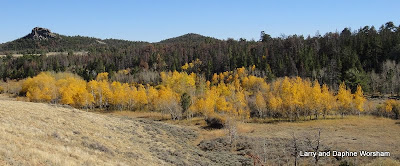
Medicine Bow Forest view
On Tuesday we ventured into Laramie to check out the sites. Our first stop was the Lincoln Memorial, which we had seen from the highway when we first arrived.

It's pretty hard to miss the monument, which stands over 48 feet tall!
Completed in 1927, the Lincoln Highway, the prototype transcontinental route designed for automobile traffic, stimulated highway improvement. It later became federally marked U.S. Highway 30. In the 1950-1960s Interstate 80 was built to carry east-west traffic through Nebraska. Though I-80 parallels the Lincoln Highway route in many counties, the older route continues as a part of the federal highway network.

The monument is in a rest area that also contains a really nice visitor's center, which offers a wealth of tourist information about the area.


Next stop on the list, the famous Territorial Prison, one-time home to Butch Cassidy and several other notorious outlaws.

The entire building is open to visitors, so you can wander among the cells, view the kitchen, dining hall and infirmary, learn about how the restoration work was done, and enjoy the historic displays that eloquently portray the lives of several notable criminals as well as the lawmen who served in the territory at the time. The restoration has been beautifully done, and all the outbuildings add to the experience. 

The prison has had several incarnations, as a theme park, as a livestock farm for the university, and now, historic site.

A bit of each is here for visitors to enjoy, along with several opportunities for living history experiences, such as the broom making factory.

This was a major industry for the inmates, and now reenactors make brooms in the large building that was used at the time, in the same way the inmates did. You can purchase one in the gift shop - three sizes - I bought a nice little whisk broom for the fireplace at home. 'Handcrafted by Dave, the tour guide told me.

Broom-making room at the prison
After touring the prison we refreshed our flagging energy at the Altitude Chophouse and Brewery with an excellent lunch and a couple of very good brews. We can highly recommend the Altitude Amber Ale, and the monthly special, American Rye Ale.

My after-lunch treat was a quick shopping trip to the quilt shop right next door to the pub. We drove around downtown a bit, identifying several places we'd like to check out on our next visit, and  then it was back to camp for us to rest up for the next day's travels.
(click on any photo for a larger view)

Tuesday, October 2, 2012

Jordanelle State Park and a fast trip across Utah

We spent three nights at Jordanelle State Park. This was our second visit to the park, as it's a convenient place to stay when visiting my sister in Park City. Our last visit was in July of last year. See that post for more information on the park and the surrounding area.

The park is beautifully maintained, as they have an ambitious group of volunteers. Most of the sites have a view of the lake, though this lake (reservoir) is suffering from the same lack of water that most others are this year.

The dark water line on these trees shows how much lower the current level is than it has been in recent years.  The exposed shoreline is now down to such a low level that the beach is all mud, so I attempted to keep Shiner up on drier, firmer ground when we went exploring. Somehow she still managed to sink up to her elbows in lovely, black swamp mud. Even after a good hosing down she was perfumed faintly with dead fish and pond weed. 'Guess that's the price of having a country dog who likes to explore!

We spent the two full days here visiting, catching up on laundry in the park's little two machine laundromat, and completing the repair on the damaged kitchen vent.

We're still recovering from the germs, so plenty of recuperation time is still on the agenda. The surrounding hills here are covered with beautiful fall colors, so it's a great place to sit back, relax and just admire the scenery.

Monday, we made a 9 AM departure from Jordanelle State Park, north on hwy. 40  then east on I-80 through the canyon. With it's fiery red canyons filled with brilliant yellow and red trees it made a grand exhibit as we left the state.

All too soon the red canyons faded into layers of beige and green, sedimentary layers deeply eroded into interesting shapes, with sharp outcrops of harder stone here and there.The low hanging autumn sun makes the shadows on the eroded hillsides even more outstanding.

As we entered Wyoming the highway flattened out to the rolling, sagebrush covered range land of the northern Great Basin. This is definitely cowboy country. Not much but range land, cattle, and prong horns.