Tuesday, August 30, 2011

Tailgate Training Camp, Ochoco Forest Campground, Oregon

This pre-football season four day camp-out has become a tradition for us and our tailgating friends, whom we see only during football season.

We've met in this group campsite for so many years we've lost track (probably about eight years), so it feels like home. It's a great opportunity for us all to just sit back, relax, visit and talk football (among other things). With tents and RVs tucked into the trees, and the huge log shelter available for cooking and dining, we have all the comforts of home.

Smoke from the fires on the Warm Springs reservation hung in the air, more visible some days than others. We did have a little lightening during our stay, which unfortunately started a fire near Black Butte. The forestry service had firefighters and equipment staged around the area in strategic locations so they would be ready as soon as a smoke sighting was reported. They really are organized and on top of the situation here.

We took a day drive to Walton Lake, which was closed last year for remodeling. They have done a beautiful job of improving the camp sites and the trail, as well as adding some nice little paved areas for fishing, so the lake is now more accessible for the handicapped. Several people were fishing when we were there, some doing pretty well too, as the lake was stocked with all sizes of trout earlier in the spring.

Training Camp was as successful as ever, with the guys happily sporting their new party duds, supplied by Dave who obviously had a good time shopping on his last trip to Alaska.

The afternoons were devoted to serious games of "washers" and watching the livestock, who clearly knew (better than the humans) how to really relax.
All in all, we feel fully ready to meet the season head-on, and all we can say now is, GO DUCKS!!!!

You can witness more of the shenanigans in the album.

Anson Wright Memorial Park, Oregon

Knowing we need a few days of rest and relaxation to prepare for Tailgate Training Camp, we met friends from Portland at the Anson Wright Memorial Park campground for a few days. It's a calm, quiet, out of the way campground, and good for visiting with no interruptions.

This little campground  (Morrow County, on SR 205) has a little fishing pond on one end, and a creek running along the road near the tent sites, but the RV spots are all uphill, away from the creek, which is probably why we didn’t have much in the way of mosquito problems. The utilities are rather strangely arranged in some of the spaces, so check it out before deciding which site to select.

As the park is only a few  miles from the Sheep Rock Unit of the John Day Fossil Beds we thought we’d take a drive down that way.  We stopped at the visitor’s center, then had our picnic lunch at the James Cant ranch house, which was unfortunately not open for tours on this particular day – just our luck. It’s a really pretty ranch, with several original buildings, well maintained lawns and orchards, all backed by dramatic cliffs. It's a beautiful setting, and the ranch house itself is nicely restored. We were able to tour it the last time we visited this area and really enjoyed the displays inside.

It’s a scenic drive through the park, past multicolored layers of volcanic ash and basalt, fantastic eroded cliffs, and some very prosperous looking ranches.

After leaving the park complex we stopped at the Dayville Mercantile for ice – what a great little store! A little of everything, friendly folks, and they really know how to grow the petunias!

Our last night in camp featured a dramatic two hour lightening show, with just a bit of rain. We sat under the awning and watched as the campground was repeatedly lit up like a football stadium, and contemplated how many fires might be started by the strikes.

On the road the next morning I was able to grab an Internet connection and located a news article that stated::
Strong thunderstorms raked Oregon and western Idaho with more than 8,000 lightning strikes Wednesday, igniting more than 100 new fires on the High Desert that for the most part were stopped small.

We saw the evidence of the fires as we drove west under smoke filled skies, to the Ochoco Forest campground, for Tailgate Training Camp. We will, again, be out of Internet access for several days, so updates will be a bit delayed.

Thursday, August 25, 2011

YEE-HAW!!! Pendleton Oregon

Pendleton, Oregon –  Rolling wheat fields, cattle ranches and home of the famous Pendleton Roundup. The roundup is a huge rodeo event and pageant, held every September.  We’ll be gone by then unfortunately, but we did have time to visit the  Pendleton Roundup and Happy Canyon Hall of Fame, where we talked with the docents about the history of the event and admired memorabilia of all types.

We learned the story of Warpaint,  the mounted (as in "stuffed") horse that greeted us as we entered. He was a bronc who was famous for his ability to toss riders, and who liked to bite! That’s why he’s posed with his mouth open. The displays included historic Native American costumes and beadwork, rodeo clothing and leather work,  a lot of historic information regarding the rodeo itself, and a full size teepee.

The hall of fame is right across from the rodeo arena, so you can really picture the event. Happy Canyon is the back side of the arena, which fills up with a Native American village and hosts the pageant portion of the rodeo. The bronze in front of the arena is world famous, not only as a symbol of the rodeo, but also as the logo for Pendleton Whisky.

Some folks will think we're crazy, but as we aren’t too fond of crowds we’re just as happy to see it before the festivities are set in motion.

Pendleton, in addition to the rodeo, is a neat western town to visit. The old downtown has some really classic  old cow-town buildings, most filled with modern “saloons”, western wear shops, restaurants and the like. The famous Hamly Steakhouse wasn’t open for lunch, but we were able to go in and got a brief “tour” from the manager – what a beautiful establishment! And talk about historic furnishings. . . the divider between the restaurant and lounge is the tellers counter wall from the last bank that Butch Cassidy and his gang held up, while the bar back itself is Victorian and came from a town in Montana. The whole restaurant is beautifully done, and their prices didn’t look too bad.

I paid a visit to the Pendleton Quiltworks, which has to be the friendliest quilt shop in the state, and picked up a few pieces of fabric for my projects. Meanwhile, Steve chatted with folks a couple of doors down at the Prodigal Son. I joined him later for a cold one and lunch. (We tend to schedule my quilt shopping at stores with a pub nearby.) There was a moment of deja vu as I looked around the room and noticed a large print of Dr. Pierce's Barn, which is in Cottage Grove (where we used to live).

In addition to the rodeo, Pendleton is also famous for the Pendleton Woolen Mill, producers of wool blankets and clothing, so we couldn’t pass up a chance to visit the mill and take their tour. It was very informative and we learned a few  interesting facts – first, all the fabric for clothing is made in the Portland, Oregon, facility which also does all the dying and washing of the wool and finished products. The mill in Pendleton cards the wool, spins the yarn and weaves blankets.  It’s quite a partnership between the two mills. We also learned that some of the looms they use for tapestries are quite old, but have been computerized, and they produce some fantastic products. We saw a few of them on the walls of the mill during our tour. We have a little album from the tour, if you are interested in how the process works.

While in Portland we stayed at the Wildhorse Casino RV park. As casino parks go it’s pretty nice, especially if you can get one of the spaces along the back row as we did. We had a nice, open wheat field behind us and a fairly spacious grassy patio area.  Wildhorse is a Native American casino, and we noticed that, in contrast to many Native American casinos we’ve visited, most all the staff here actually is Native American.  The tribes seem to be doing a top notch job of managing the business too – they were racing to finish at least seven floors of a huge new hotel complex on the  casino, with the goal of being ready for the Pendleton Roundup rush.


Adjacent to the RV park is a beautiful cultural center called Tamastaklikit. We very much enjoyed our visit. Displays and videos cover the history and culture of the Cayuse, Umatilla, Walla Walla, Nes Perce and other tribes in the area. There are several examples of different housing types in the outdoor area that often house crafters, demonstrating traditional arts. The young craftspeople we met out in the tule reed shelter were beading jewelry at the time, and were very friendly and conversational.

Our last day in Pendleton was devoted to stocking up (again!) and getting ready for a meet-up with friends at Anson Wright, a county park in Morrow County. ( on SR 207)

Sunday, August 21, 2011

Installing EDWIN - another RV remodeling adventure

No, we didn't put my father in the ol' RV.  . . . here's the story.

The one drawback to the floor plan of our Arctic Fox trailer is that there is limited ventilation in the bedroom. When we're out in really hot weather a little cross-ventilation would be nice. I once suggested putting a window in the wall next to the door. The Wagon Master (a.k.a. chief mechanic and RV maintenance guy) looked at me as if I'd finally go 'round the bend and informed me in no uncertain terms "We are NOT cutting a hole in the wall."

OK then . . .'not to be stymied in my search for fresh air, I hit the Internet and after searching several RV replacement window sites, I came up with the Atwood EDWIN - short for Entry Door WINdow.

This little treasure fits the existing door window opening and the window in it opens!! It was really easy to install (I can say that as I actually helped), and appears it will be trouble free. We'll see if it provides adequate air flow when were out on the road. We do leave the door open if it's really hot, but this should be a nice intermediate solution. We also have a foil blanket to Velcro over the window for light and heat control when we need it. Problem solved! 'Wish all our remodeling jobs were this simple! We're still waiting for parts and pieces for the solar project, when we've got all the materials we'll launch into that.

 After almost three months on the road we can now honestly say that the window was a good solution, but, we discovered after the first month that we needed to go a few steps further. First, the window glass is smoked, but not textured, so at night with inside lights on you can see into the bedroom, and because the foil blanket I mentioned covers the entire window, and the screen door blocks access to it from the inside, we decided we needed another "light control" solution. We went to a hardware store and bought some "privacy" window film and put that on the window, solving the privacy problem. Then, I made a curtain out of fabric heavy enough to block all the light. It pulls to the side during the day, so it doesn't hinder use of the door, and air can flow around and under it at night if we have it pulled all the way closed. It seems we now have all issues resolved.


When we visited the Northwood factory (see previous post) we inspected several new trailer models, and saw stacks of windows ready for installation - they all looked like the Edwin! Apparently the same company is supplying them now. The new version of our model does have a window in the bedroom, so the airflow is improved, but if you have an older 30U, or some other RV model that needs increased ventilation, this solution might work for you.

Friday, August 19, 2011

LaGrande, Oregon

We planned a stop in the little eastern Oregon town of LaGrande to get some repair work done on our Arctic Fox at the Northwood factory. Our rock cover on the front window has been a problem for awhile now, and we've patched it a couple of times, so we decided it was time to move on to a new one.The factory recommended nearby Eagles Hot Lake RV Park as a good place to stay as it's really close to the factory. It turned out to be a great recommendation. We had no idea what else was around the RV park, so we were in for a pleasant surprise.


The park itself is very picturesque, nestled in at the foot of Craig Mountain  with the old Oregon Trail running behind it and Ladd Marsh Wildlife Refuge  right across the road. The trees in the park aren't very big yet, but the spaces are generous, grassy, and everything is well maintained. Ladd Marsh offers a wealth of wildlife viewing - over 200 species of birds in addition to the occasional deer and elk. There's a creek running right through the park, a pool and spa, and a laundry room. The real treat however is  Hot Lake Springs, spa and bead and breakfast, that is located right next door. This establishment has quite a history.

From pioneer days, when the trail ran along the base of the mountain and travelers stopped here at the trading post, to the 1900's when a luxury spa and sanatorium (hospital) was established, to the current incarnation as bed and breakfast/art gallery/history center.

The draw of the property way back into Indian days was the hot lake waters which were believed to have healing properties. The area was considered "tribe neutral" because of of this special attribute, so even warring tribes could meet here on peaceful terms.Today, the hot waters are piped into soaking tubs in the spring house.

In 2003 Manuel family purchased the property and began restoring it. It was in terrible shape after many years of neglect. Renovations have taken years - they have been open for guests since 2010, but just held their grand opening in early August of this year.

They moved their bronze sculpture foundry business and gallery here from Joseph, and are now in the process of providing space the their gallery for other artists. There's a little gift shop and antique shop in addition to the gallery, so shoppers will be delighted with the range of choices.

Many of David Manuel's amazing sculptures are situated around the grounds, and smaller versions of many of them are available in the gallery.

For a small fee you can tour the grounds, view the beautifully appointed guest rooms, and experience two floors of Native American artifacts, artwork, military and pioneer history. The entire facility is an experience, as there are little cabinets and show cases tucked in every lounge area and available corner, all filled with various antiques and collectables. We spent a little more than two hours there. They have a restaurant too, so it would be easy to make a day of it.

We dropped off the rig at the factory at 7 A.M. With time on our hands until the repair was finished we asked about a good place for breakfast. The Flying J truck stop was suggested, with the caveat "I hope you're really hungry".... it was a good suggestion, as the food was great and plenty of it. Not just fried eggs and ham either - I had crepes with berry sauce - delightful!

Our appointment at the factory went well. The new rock cover's design is a big improvement over the old one, and they managed to find one with graphics similar to those on the trailer itself. We also learned the secret to removing the window screens so we can thoroughly clean the windows, and obtained their expert advice on a few other questions. 'Nice folks, and very helpful! We were back on the road with our repaired rig by 10:30 A.M.

For more views of the Hot Lake Springs facility and grounds check out the album.

Next stop - Pendleton, Oregon.

Tuesday, August 16, 2011

A vacation from retirement

All this touring and visiting exciting places is great, according to the Wagon Master, but sometimes you need to take a vacation from retirement. So, he found us the perfect place.


Catherine Creek State Park is along hwy. 203, near Union, Oregon. The campsites are laid out along Catherine Creek, and there's a nice day-use area just a half mile up the road. There are no services, but there is water available. It's a beautiful area, with camp sites that vary from small, suitable for tents, to several that will accommodate larger rigs. Only a few are right on the creek, and we were lucky enough to arrive early in the day, early in the week, and snag one of the very best.

Catherine Creek isn't very deep - great for kids to wade in as there are several little sandy beach areas. Though we did see people fishing in it, I can't say I saw anyone catching a fish!

There are also a couple of nice trails, one to the day use area - it's a one mile round trip, and another up to the top of the hill where there are a few nice viewpoints. It's a two mile round trip, and does have a few steep areas. Molly and I took that one on our third day there - not too bad for an old lady and an old dog!

We took one afternoon to go into the nearby town of Union where we visited the Union County Museum and picked up a few items at the little grocery store.

MC Ranch branding iron
The museum is really nice, and the loving attention lavished on the collections by all the volunteers really shows. The displays are really well done, and include an unusually wide range of topical material. One whole room is devoted to a "Cowboys Then and Now" collection.

Small "rooms" display items as they would have been used in days gone by. The whole town is a well-preserved turn-of the century treat. The grocery store, situated right on the creek, is well stocked with a bit of everything. The proprietor is a friendly fellow who will happily visit and fill you in on local events.

Four days is long enough to really get settled in to an area, and by the time we left we'd become well acquainted with our host and hostess and two of the other couples camping there. We spent the afternoons trading travel tips, favorite campsites, and learning about the surrounding area from the couples who were familiar with it.

There's no cell service in the park, but you can catch a signal a couple of miles back toward town. We never bothered to set up the TV, opting to take a vacation from everything! All things considered, while the rest of the world was focused on the stock market melting down, world politics, and all the talking heads on TV, this was an excellent place to get away from it all! A few more photos here.

Our next stop will be far more "civilized". We've an appointment with the Arctic Fox factory in LaGrande for a repair, so we'll be staying at a private park nearby. 

Thursday, August 11, 2011

Oregon or Bust!

Did you ever play that Oregon Trail computer game when you were in school? Or maybe you worked through it with your children, making those critical choices about what to bring in the wagon and what to leave behind. Take a ferry or tow the wagon across? So many decisions!

If you did play the game, or if you've studied the Oregon Trail, then you'll remember that the river crossings were one of the biggest challenges along the way.

It was no game for the pioneers. They lost wagons, stock, and sometimes people in the turbulent waters. Our next two stops, as we work our way toward Oregon, are at two of the most famous of these Oregon Trail crossings.

From the City of Rocks area we traveled northwest, sticking primarily to the back roads. It's a pleasant drive, through rolling plains and small farming communities. We took a break around lunch time, stopping at Hagerman to visit the Hagerman Fossil Beds National Monument.

This monument is a good place to learn about Idaho's "state fossil", the Hagerman Horse. The creature, which first appeared about 3.4 million years ago, was a member of the genus Equus, but not really a horse by modern standards. It was much more like today's zebra, and became extinct about 10,000 years ago, along with several other large species. The park holds the largest concentration of Hagerman Horse (Equus simplicidens) fossils in North America. They have a nice visitor's center right in the town of Hagerman, and then a driving tour where you can experience overlooks of the scene where the fossils were discovered. The visitor's center also houses a temporary display on the history of  the Minidoka Internment Camp.

We elected to skip the driving tour and continued on west toward our camping destination. Looking out the window I was startled to suddenly see waterfalls gushing from the steep cliffs along the river. Soon we passed a sign explaining this was the Thousand Springs Scenic Byway.

Truly, I've never seen anything like this. The springs gush forward with such force that in some cases the water shoots out like a fire hydrant, in others, the effect is a graceful waterfall. The water source is the Snake River Plains Aquifer, one of the largest groundwater systems in the world. It creeps through an area of several thousand square miles under southern Idaho's porous volcanic rock before emerging from the springs in the cliffs. The water is a fairly consistent 58 degrees or so, and so very favorable for trout. Fishermen, take note!

Our stopping point the first evening was scheduled for Three Island Crossing State Park, located at Glenns Ferry, Idaho. There is an Oregon Trail historic center here, but as our luck usually has it, the center is closed Mondays and Tuesdays, and we only planned to be in the park on Monday. There are several signs around with information about the area, so we did a bit of a self-guided tour and called it good.

The park is beautiful! There are two camping loops, and though the sites don't have a view of the river, there are trees and lush grass everywhere. Sprinklers are running somewhere in the park pretty much all the time, thanks to the availability of river water. So lush and green, it was hard to pack up and leave.
Three Island Crossing

But, we are headed for appointments in Oregon, so leave we did. Next scheduled stop, Farewell Bend State Park, in Oregon.

We arrived early in the afternoon hoping to beat the crowds as we didn't have reservations. As it turns out there wasn't much competition. We set up camp at the end of the lower loop, under a nice tree. Our view also includes rolling golden hills covered with sunflowers as well as the river, another famous Oregon Trail crossing.

Farewell Bend was the last stop on the Oregon Trail along the Snake River where travelers could rest and water and graze their animals before they said "farewell" to the Snake River. From this point the trail turned north through more rugged country to follow the Burnt River.

We aren't facing such an arduous journey, and we've no animals to graze (Molly's not too fond of grass) so we recharged our selves by relaxing with a cold one under the tree and watching the nighthawks dip and soar. I've never seen them out quite so early in the evening, or quite so active.
There were dozens of them in the air, and they were sailing across the lawn only a few inches above the ground. I'm more accustomed to see them higher up, above the tops of trees. Wherever they fly, I'm happy, as they're eating bugs!
Farewell Bend

We've decided to stay at Farewell Bend a second night, then push on, down the trail, location TBD.

(Click on any photo for a larger image)

Tuesday, August 9, 2011

City of Rocks National Preserve, Idaho

Dolphins and whales leaping from a blue-green sage colored ocean. Huge, gray elephants lumbering across velvety green slopes. A tiny cirque, high up on the distant hills, is all that remains of the winter's snow, and a few wildflowers dot the plain. That's the scene here in City of the Rocks National Preserve. 

Well, the critters may be imaginary, but the forms are real. These giant gray granite outcrops certainly inspire those images. 

Saturday we drove west, through the park, admiring the formations and checking out the named boulders.

There's Camp Rock, where travelers found protection from the winds, Treasure Rock, that supposedly marks a huge buried treasure, and Elephant Rock, inspired I'm sure by the effect of the gray boulders on the plain.

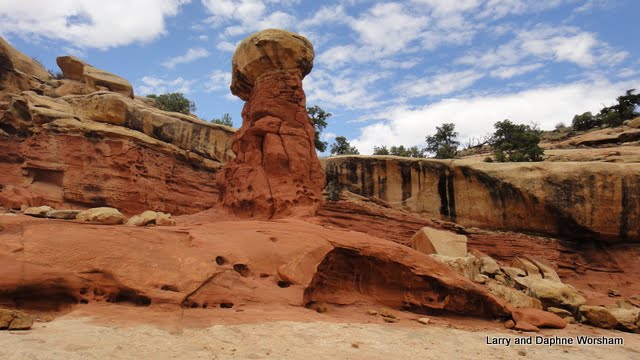
After all the red sandstone we've seen, these gray granite outcrops seem such a contrast. And they come as a surprise after the drive through the rolling wheat fields of southern Idaho. Although all the formations appear at first to be made of the same type of stone there are actually three different materials involved in creating this amazing landscape.

One, the Green Creek Complex consists of granite formed around 2.5 billion years ago.  This type has a high mica content and glitters in the sun like diamonds. The second, the Elba Quartzite originated during the Proterozoic Eon a mere 15,000 to 600 million years ago. This stone is much lighter than the Green Creek granite, and also has mineral stains causing red and green streaks and layers. The third type is the Almo Pluton, granite, formed by the slow cooling of magma, makes up most of the spires in the City of Rocks. (More about the geology of the area here.)
The Twin Sisters formation is interesting because the left peak, of the Twin Sisters, is made up of rock from the Green Creek Complex (2.5 billion years old), and the right peak is made up of rock from the Almo Pluton (28 million years old). Some birthing process!

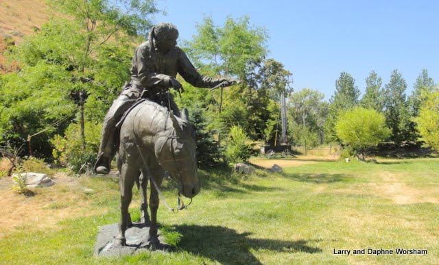
This preserve is notable not only for the geology, but for the pioneer history, as the California Trail (companion to the famous Oregon Trail) passed right through the center of the park.

Register Rock records some of the names and dates. Many more were written there, but have long since faded due to weathering. Only those protected by the overhang of the boulder remain legible.

Turning east there's a view of the smooth plain the wagons crossed to get to this point. Its grassy, and looks like easy going. Turning west, the view is only broken rocks and steep slopes. One can only imagine what thoughts the pioneers had at this point about the challenges lay ahead. The ground is solid with small boulders, and the granite spires crowd each other, often leaving little space to get a wagon and team through.

 The stone ruins still standing beside the road mark one of the locations where the California Trail crossed the current road. Originally settled in 1882 under the 1862 Homestead Act, the land was sold in 1901and patented under the Desert Land Act. The combined acreage formed the nucleus of the Circle Creek Ranch. The Tracy's spent years constructing a substantial stone house to replace their log dwelling. The stone used in the construction of the home is from a quarry located about one mile southwest of the home site. The home burned in 1957. (A nice driving tour brochure that includes many of the historic and scenic points is available here.)

Today's adventuresome types come to this area not as pioneers, but as rock climbers. Though the state park campground we are in, Smoky Mountain, is very sparsely populated, the boondocking camps out in the bushes, near the climbing rocks, are swarming with people. Each of the cracks and crevices seems to have a name, relevant to the climbers, and there clear signs directing people to the base of the formation where the way up begins. Many of the parking areas around picnic areas and climbing sites were full today, when we drove through the park. I can't imagine what it must be like here during the spring, which is the peak season. 

At the edge of the park we went north to the little town of Oakley. The town has less than 600 residents, and their main claim to fame is a historic section with a few really nice Victorian homes.

One of the major industries in the area is stone quarry products, and there are several stone dealers around to prove it. I wish I could get some of this back to Texas! They have some really attractive types in the display areas.

Once back in camp we noticed the storm clouds gathering. This seems to be a regular afternoon thing. Big, billowy white clouds suddenly turn dark, then the thunder starts, and then a few sprinkles. This was a bit more lively than the day before, though. With a little hail and a lot of wind thrown in. We battened down the hatches, so to speak, so we wouldn't have to worry about things and took off for the nearby town of Almo to have dinner. We don't eat out much, so having someone else do the cooking is quite a treat. We went to the Outpost Inn, a nice little steakhouse type restaurant. Good food, and some interesting Native American items decorating the place.

Our big outing on Sunday was a drive to the state park right next to City of Rocks. Castle Rocks State Park is much smaller than the national park, but much the same in appearance. It's also popular with climbers, and it's probably to them that we owe the great cell service in this area, as well as the fact that our campground has wireless.
Smokey Mountain campground, where we are staying, is actually part of the state park, though it's separated by a couple of miles. It's a really well designed campground. The spaces are wide, level, and very private, and there are a couple of yurts available for those without an RV. There's also an equestrian section that includes holding pens for horses and plenty of room for stock trailers. Showers, recycling centers, full hook-ups, and a thunderstorm every afternoon at 3:00. The spaces are surrounded with sage, yarrow, juniper and pine that send out heavenly aromas when the afternoon showers hit. What more could anybody want?

Well, actually, I could want better signage. When we arrived at the park we noticed a sign at the edge of the parking lot with a list of things we might see there, but no arrows or directions, and the world's dinkiest map was posted for reference, so after a lot of hiking around in circles we finally found what we were looking for - some very faint pictographs! See the notes in the photo album if you are interested in tracking them down.

The ranch house that is part of the park is now an inn of sorts, and so not open to anyone who is not a guest of the inn. It's a cute little building, but we don't know anything about it, as there was no information available at the park.

A single visitor's center, in Almo, serves both parks. You can get brochures and shop for gift items there. There's also a mercantile and another food and misc. items store in Almo, so if you forget something you can probably pick it up there.

Another storm came up late in the day, and this time brought a double rainbow over the valley. The perfect finish to a perfect day!

Saturday, August 6, 2011

Heading north, to the The Golden Spike

Heading north from Capitol Reef it's a long way to anywhere, at least at the rate we travel. Though we've racked up 5,000 miles so far, we've only been doing 40 or 50 miles between stops on most days. You can't get very far at that rate, so Steve plotted out a couple of 150 mile days to get us "up north" where we can do some shopping and visit the Golden Spike historical park - one of the items on his bucket list. 

First stop after Capitol Reef: Yuba State Park - no relationship to Yuba City, California.  Here's the story:
Yuba Reservoir (officially named Sevier Bridge Reservoir) was built to store water for agricultural and industrial use. Construction on the dam began in 1902. The local farmers and ranchers had to build the dam themselves or risk losing their water rights. Men working on the structure called it the U. B. Dam. As they worked they sang a song that stated they were "damned if they worked and damned if they didn't." The phonetic sound became the reservoir's dam, eventually spelled Yuba.

It became a state park in 1969, and it is one of the nicest "family" parks we've seen. There are little swimming areas, boating, fishing, each campsite has a nice lush patch of grass, and there's a snack bar and water vehicles rental shop too. They're putting in a sand vollyball court, and there are a couple of cabins for non-campers. The park is very neat and clean, and clearly well cared for all the way around.

In stark contrast, our next stop, in Brigham City, was  Willard Bay State Park. 'Selected because there isn't much else in the area that would get us close to the Golden Spike park, as well as the shopping we needed to do. The park sits between Willard Bay Reservoir and I-15. Cottonwood Campground, where we stayed, has full hook-ups, but is right by the freeway so very noisy. The campground is rather grubby and neglected looking, and we hardly saw a host or ranger in the three nights we were there. When we did see them they were blasting through the campground so fast that I'm sure they weren't paying any attention to what was going on in the park.
The primary draw of the park is water sports, and we'd probably be more appreciative of the park if those were our interest. The location did serve it's purpose however. We got the shopping done, and made a day trip to the Golden Spike Historic Site.

The building of a transcontinental railroad is such a quintessential piece of American history that we couldn't leave Utah without visiting the place where east and west met: Promontory Summit.

It is at this point, after years of laying track, the Central Pacific Railroad and the Union Pacific Railroad converged their two lines. Immigrants from all over Europe, Civil War veterans, Chinese, American Indians and ex-slaves all worked on this project that many said would never be completed because of the barriers posed by geography. Six years after it was begun, the visionary leaders of both companies, and those who backed them, proved the naysayers wrong. For better or worse, the rail line served to open up the west to settlement. After that it was only a matter of time before cities sprang up all over the plains, all the way to the west coast. This one artery had so much impact on the character and growth of the U.S. that it's a little overwhelming to think about.

Golden Spike National Historic Site is managed by the National Park Service, and they've done a really nice job on the visitor's center displays.

There are reproductions of the two engines that participated in the original ceremony, both lovingly cared for by volunteer engineers and firemen. The 119 was steaming down the track when we arrived, blowing that cheerful whistle we all associate with the old trains. It pulled in to the siding just as we arrived at the viewing area.

A short presentation by a ranger, track-side, filled in important details about the engines, and gave visitors a chance to have their questions answered.
There's a driving tour too, where real train aficionados and history buffs can see old trestle sites, work camps, and other points important in the development of the line.

Definitely a day trip worth the effort!

On our approach to the Golden Spike park we noticed a sprawling industrial complex near the highway., so on the way out we decided to check it out. Talk about a contrast, this time in transportation systems!

The plant is ATK Space Systems. You can't help but notice them, as they have a great display of rockets right on the highway. Each item in the display is labeled, and this would make a great stop for anyone interested in rocketry.

ATK was the prime contractor for the solid rocket booster motor that lifted the space shuttles into space for more than 30 years.  According to the local paper, now, with the shuttle program ending, they've had to lay of 2,200 workers since 2009 - including 100 just this week. This is hard on this small county of Box Elder, that has an unemployment rate of nearly 10%, the highest in the state. The company is now looking for "other uses" and customers for their booster motors. One potential use is a joint venture with the European Space Agency.

This was our last stop in Utah. Now, it's north to Idaho!
For a few more photos of the engines, check out the album.

Friday, August 5, 2011

Capitol Reef National Park, UT

Capitol Reef National Park, what an absolutely gorgeous area!

Many of the interesting features of this park are right on hwy. 24, so you can begin experiencing the pioneer history and scenic views before you ever reach the visitor's center.

We entered the park from the east, so the Behunin cabin was the first pioneer remnant we encountered. It was built in 1882 by Elijah Cutler Behunin, and his family of 10 lived in it for quite some time, the older children sleeping in a dugout near the house. I think our RV is bigger than this house!

Though there is a lot of pioneer history here, the park is named for the amazing geologic formations: Capitol, for the dome shaped formation resembling the national Capitol building, and reef, for the barrier posed by the rocky ridge (like a reef in the ocean) that is also termed the “water pocket fold”.

This “fold” was created when a huge section of layered crust was pushed up. Now it erodes in fascinating bands of color and texture, the up-lifted angles visible along the line created by the fold. Many of the most outstanding forms have unique names, which helps a little in orienting yourself in the landscape.

We arrived early enough to get a nice spot in the Fruita campgound, on the end so we had no neighbors in our outdoor area, and within view of the horse corral at the Gifford Homestead, which is right next to the campground. There’s water available here at the dump station, but otherwise, only vault toilets, and no electricity. No cell service either, so it’s a great place to get away from it all!

After setting up and a break for lunch we hit the visitor’s center to pick up brochures and plan our visit. On the way back we stopped at the blacksmith’s shop, and then the Gifford Homestead house, which is also a gift shop. Fruit pies, homemade ice cream, preserves, and handmade items stock the shelves in what used to be the kitchen of the home. The other rooms are furnished with period items. We couldn’t resist and brought home a peach pie, yummm!

The settlement here in the valley was called Fruita (pronounced “Fruit – ah”) and at one time home to 10 ambitious families. They farmed, raising livestock and all kinds of fruits and vegetables, and sold some of their surplus for cash. The fruit trees are still here, and in Loop C of the campground the apricots are ripe this time of year. Visitors can pick all they want to eat in the orchard, or pay $1 a pound to cart some away. A lot of folks were having a great time enjoying the fresh fruit, and photographing the deer that wandered through the orchard to eat the windfalls.

Day one included a drive up to the end of the Scenic Drive, and a few short hikes. The road is under construction, so we had to dodge cones, caution tape and heavy equipment along the way. The upside - the road will really be nice when they finish.

This was once the main road.
A continuation of the main Scenic Drive roadway at the southern end is called the Capitol Gorge Road. Up until 1962 this was the main thoroughfare. 'Pretty amazing when you look at the narrow width of the canyon. In many places two vehicles could barely pass, and it washed out regularly. Because it is so narrow there isn’t even any place to go up and out of a flash flood if it hits. Now it’s primarily a hiking path, into some very faded rock art and a panel with pioneer signatures. There’s been a great deal of destruction to both, to the point of making the petroglyphs almost invisible. Fortunately, one of the pioneer panels is so high up it has escaped most of the vandalism.

Day two – We drove back out to hwy. 24 before lunch. So many of the scenic views are along this roadway it’s a tour in itself. There’s some really good examples of Fremont rock art, which the park service has built a nice wooden walk way around, some fantastic views of some of the formations, and an almost aerial view of the goosenecks in Sulphur Creek.

We also stopped to check out the old Fruita schoolhouse. This tiny little building, heated by a potbelly woodstove, often held classes of up to 28 children, of varying ages. Quite a contrast to today’s schools!

It’s hard to convey the scope and scale of the panorama here. Occasionally our photos will have a car, or a few people in the distance for comparison, but without that, it’s impossible to describe. The colors, too, are beyond description. The shades and tones, further enhanced by shadows and the shifting sunlight. . . if you painted these scenes you’d be accused of making them up.

I thought I had seen pretty much all there was to see here, and then after lunch decided to take the trail that leads off right across from the campground – the Cohab Canyon trail. It’s billed as “moderately strenuous” – but don’t try it if you have bad knees! The first ¼ mile or so is steep steps and very rocky. After that the grade lessens, but there are still some challenging angles. If your legs are up to it however, it’s worth the effort. I had intended to only go part way, but each bend brought new colors, patters, the suggestion that something I just couldn’t miss lurked just around the corner. The trail in total is 1.75 miles long, and I really didn’t want to do that round trip, so I did turn back at probably the 1 mile mark. The opportunity to view some of the mineral deposits and erosion patterns close up should not be missed!

We really have enjoyed this park, and count it as one of the highlights of our time in Utah. A bonus on this visit, our neighbors in the next site, Bob and Judy from Scottsdale, AZ were great to visit with. We swapped ideas for future trips and had a great time visiting each evening.

If you'd like to see more of the park, check out the additional photos in the album.

Thursday, August 4, 2011

The road to Capitol Reef

 Highway 95 to Capitol Reef follows White Canyon most of the way and the scenery along the highway is just as colorful and picturesque as any of the parks we’ve visited. The cliffs on both sides of the road are a continuation of the same sandstone we saw in Natural Bridges, carved into fantastic shapes, with interesting names like “The Cheesebox” and “Jacobs Chair”.

North of the official park boundary the white sandstone gradually gives way to the red layer. With twists and turns in the layers, shaped by erosion, there are formations that look like over-sized dollops of pink and white whipped cream. For several miles the two colors are both evident, along with a striking blue/green layer that is such a contrast to the red that it seems much brighter than it would otherwise. There are views of the upper reaches of Lake Powell too, and all that water is a refreshing site after dry camping for so many days.

 We listened to a Navajo radio station most of the way – interesting to hear the mixture of Navajo and English words in the weather reports and upcoming events. Apparently there are no Navajo terms for “bull riding” and other rodeo events. We tried to piece in around the words we recognized and come up with a pretty interesting news report!

Flash floods are no joke this time of year, and we saw several signs along the route warning of the hazard, and cautioning travelers not to stop at the bottom of a wash. The highway had evidence of very recent flash flooding where debris had already been removed from the road, but the creek bed was still damp, showing how high the waters had risen.

Factory Butte
Nearing Hanksville the scene changes from blazing red rock to gray talcum powder. Buttes and mesas of pale yellow sandstone sit atop gray and black alluvial drifts – such a contrast to the scene just a few miles back. Factory Butte Special Recreation Management Area (BLM) looks like a great place to explore the back country and enjoy the view.

A little further on,  soft material in this area has eroded into peaks that look like meringue, with occasional splashes of rust, blue and purple. Think sifting piles of talcum powder and campfire ashes. In some areas the color pallet shifts to soft pinks, eroded to rounded domes. After ooh and ahhing our way around every corner we saw a sign “scenic views next 14 miles”. . . ‘wonder what that was we’d been looking at?

Wednesday, August 3, 2011

Blanding and Natural Bridges National Monument

After a refreshing night's sleep, in spite of the booming thunderstorm, we left Dalton Springs, continuing down the other side of the mountain in to Monticello, then south on 191 to Blanding. Blanding is in San Juan County. In the 2000 census the population was 3,162, making it the most populated city in San Juan County. Does that tell you a little something about this part of the state? Let's just say, it's not crowded here!

First stop – Edge of the Cedars State Park and Museum. This museum is definitely worth stopping for. We've seen so many museums in our travels that we've become a bit jaded, but museum is a real experience,. There are several unusual features: one is the beautifully painted rock art murals on every available blank wall. They have the largest pottery collection in the southwest, and some very rare and ancient Pueblo artifacts.

The facility is also a research center, and much of the resource material, particularly the pottery, is displayed in a glass enclosure so the public can enjoy it, as well as being able to access images and information stored in a computer available right next to the display. There’s a restored ruin with a kiva (underground ceremonial chamber) outside, which visitors can enter, and a beautiful vista of the area that once housed several Pueblo families. Down the slope from the restored kiva is an astronomical observation tube sculpture. It's designed, as some rock art is, to project light in certain places on the designs in the tube, indicating specific events like an equinox.

We decided we’d better stock up on provisions in Blanding since it would be about a week before we hit another town with a real grocery store. In this case, provisions included fuel and water as most of the camping areas in this part of the state don’t have water available, or limit campers to only a few gallons. The first gas station we check in with was out of diesel! So we tried another and were successful with fuel as well as being directed to the RV park next door where we filled up with water.

Well stocked, we left hwy. 191 just south of Blanding, going west on hwy 95, to Natural Bridges National Monument.

The visitor's center in the park is almost totally solar powered. In 1980 a solar power system was installed that for a time supplied all their power needs.  It now provides 90%, with generators providing back-up power. The visitor's center is the only place to get water, and they strictly limit amounts.

We knew the park had a campground, and one web site we checked said “26 feet” limit, which usually means the RV, and we can usually fudge a little and fit in smaller spaces. In this case we discovered, it means the total unit. As our trailer alone is 30 feet, even new math wasn’t going to wedge us into a site. Each of the spaces has a huge boulder placed at the back of it, so there's no letting the bumper end hang over the pad at all. The campground is small, and the drive has tight curves, definitely for the tent camper types.

The visitor’s center staff said we could leave the RV in the parking lot while we drove the loop, so that’s what we did. Dogs aren’t allowed on the trails, and since Molly hates traveling in the truck (you’d think she’d be used to it by now!) we left her in the trailer so she could nap. With time included for hopping out to take pictures and some short hikes to viewpoints, the nine mile loop takes about three hours. There were longer trails down to the bottom of the bridges that would have been nice, if we’d had time and it hadn’t been so hot!

Unlike the red sandstone formations in Arches National Park, which were formed by wind and other kinds of erosion, these white sandstone bridges were formed by water erosion (that’s the difference between the two terms, "arch" and "bridge"). The river rushing through the canyon eventually carved tight loops, as the canyon deepened the river broke broke through at the narrow points of the loops, at the level of the softer layers, straightening out the river and causing the formation of a bridge in the more durable sandstone of the upper layers.

This is a different type of sandstone than we saw in Arches, but this also breaks off in curved shapes, leaving caves and shelters which the Ancient Pueblo’s took advantage of. One of the short trails leads to a viewpoint of the Horse Collar cliff dwelling on the other side of the river. ‘Definitely worth the effort of a short hike! For one thing, usually you are looking up at the cliff dwellings. This is one of the few instances when you can look down on them, which is a different perspective all together.

Back at he visitor’s center we hitched up again and headed for the “overflow camping” area. It’s really just a graveled area with a few places opened up back in the trees, no restrooms or water. Considering the view and privacy we had, we felt this was an improvement over the crowded little campground.

There’s no cell service in the park, or even very near it, but we were able to catch a signal out on the highway.  It's a challenge keeping this blog updated when we can't get on the Internet, so it's catch-up time when we do finally get connected.

Check out more photos of Edge of the Cedars State Park here, and Natural Bridges here.