Friday, June 28, 2013

Kershaw-Ryan State Park, Nevada

Friday, June 21 - Kershaw-Ryan State Park is situated in a colorful, scenic canyon at the northern end of Rainbow Canyon, in eastern Nevada.


Caliente is the nearest town to this gem of a park. The campground is brand new, though the park has been here since 1926 when the Ryan family donated Kershaw Gardens (named for the original owners who farmed there) to the state for use as a public park.  

The facilities built by the CCC in 1934 were washed away in flash floods in 1984, and the new camping facility has been relocated to an area in the canyon thought to be less vulnerable to that kind of damage. They've also done a bit of work to divert any potential flooding. Raising the roadbed and creating diversion channels look like effective measures to manage the occasional cloudburst.
 

The park has a new 15-unit RV/tent campground with beautiful new restrooms that include showers. There is water available at several locations between the sites, but no electric or sewer hookups.  In a move to bring to life the early pioneer history of the area the campground also includes a small vineyard. Unusual in a campground to say the least!

Sites are spacious, and we enjoyed the view of the cliffs from the one we selected. There were no neighbors until late in the afternoon, so we had an unobstructed view of the colorful cliffs around us.

This campground would be a good home base while visiting local points of interest, like the historic towns of Pioche and Caliente.

We were fortunate to be in a place with wide open skies at this time of year. We witnessed what some call a "super moon" and took advantage of the great photo opportunity.
"This full moon is not only the closest and largest full moon of the year. It also presents the moon’s closest encounter with Earth for all of 2013."
View of the moon from our campsite


The steep, eroded canyon walls tower to 700 feet and overlook a long, narrow valley. Early settlers in the area cultivated a garden of grape vines, fruit trees. Remnants of that oasis still exist at the upper end of the canyon, along with a grass lawn surrounding a spring-fed pond that provides a beautiful contrast to the rugged landscape. There's a picnic area, children’s wading pool, playground, group-use area and trails offer visitors nature study, photography, picnicking and hiking. 

We’d planned only a quick overnight stop, so didn’t explore all the corners of the canyon. That’s definitely on the list for a return visit! This park is very near Cathedral Gorge, where we stayed in2010 (see that post). It’s an attractive area, full of history, and well worth a visit.
  Kershaw-Ryan State Park is located two miles south of Caliente via U.S. 93 and State Route 317.

Thursday, June 27, 2013

Duck Creek CG and Cedar Breaks National Monument, Utah

6/19-21 Duck Creek Campground, Utah
This campground is in the Dixie National Forest, just south of Cedar Breaks National Monument. On the map, it looked like a good bet based on location and numbers of spaces, AND at an elevation of 8,000+ feet we knew it would be cooler. It is turning out to be a good choice.

There are several loops, but only the “A” loop has the level, paved pads that are great for RVs. Snuggled in our little space we were surrounded by aspen trees that shimmer like sequins in the breeze. The spaces are spread out, and many weren't occupied, so we didn't feel crowded at all.

The volunteers at the Duck Creek Visitor’s Center, right across the highway from the campground, were very helpful with information and brochures about the local trails, back roads, and best of all, explained how the forest came to be known as “Dixie." It seems the early settlers in this area were from the southern states, and were sent by the Mormon Church to this area to raise cotton and mulberry trees for silk production. They thought the forest looked like what they knew from their southern homes, so called it Dixie.

Considering the short growing season and harsh weather at this altitude it’s not surprising that the cotton/silk enterprise was not successful, but the name stuck, as did the southern tendency to call juniper trees “cedar." Thus the name for the nearby national monument, "Cedar Breaks."

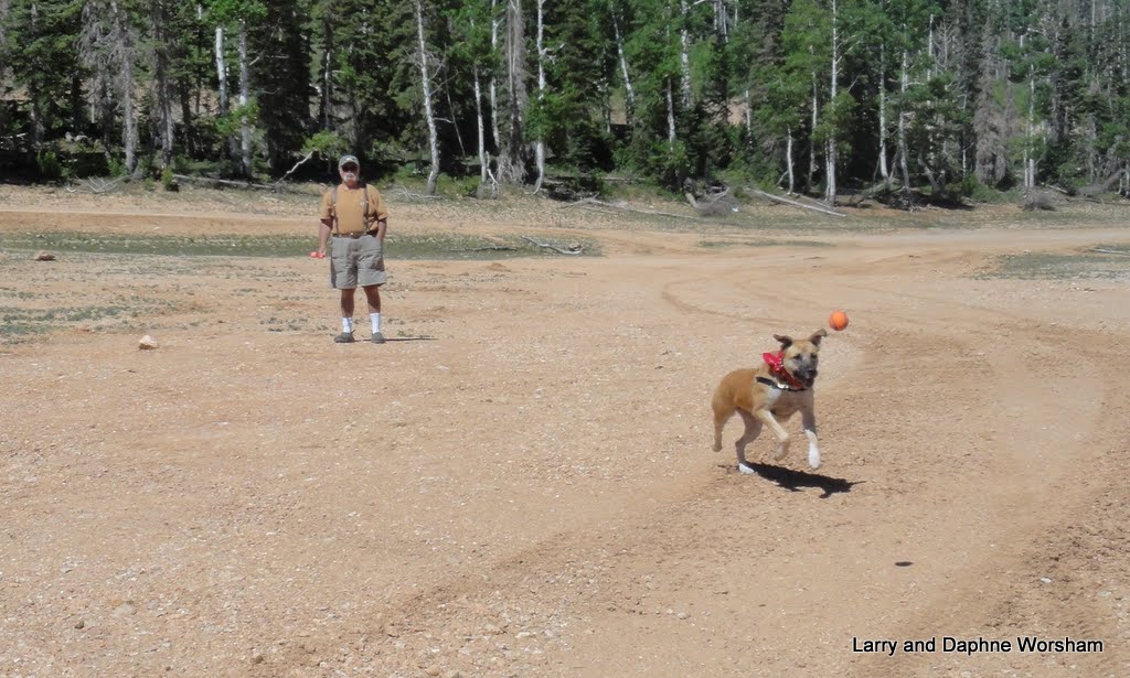
Our first day’s outing was to Navajo Lake,
which had been recommended to us by a fellow camper sometime in the past. As with all other lakes lately, it’s a bit low. We did have a good time using the mud flat at the south end to play ball and admired the wildflowers around the edge.

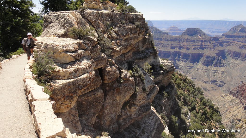
Later in the day we drove over to Strawberry Valley, down Strawberry Point Road, to the Strawberry viewpoint (are you sensing a trend here?)

View from Strawberry point toward the ridge
After creeping through a beautiful meadow where a herd of pronghorn antelope were grazing we manged to dodge construction equipment and work our way out to the viewpoint.

Beautiful red formations surround the valley and extend out in a ridge far beyond the road we were on. The viewpoint gave us a unique view of Zion, many miles away. Even considering the great distance the peaks are striking.

View of Zion from Strawberry Point
Strawberry valley is currently undergoing extensive development. The many small, modest cabins that have obviously been there for years are being surrounded by massive log and stone structures. There is heavy construction equipment everywhere, and a sense that the quiet rustic tone of the community will soon be gone.

We’ve noticed a lot of bug kill in the spruce trees around us. All across the Markagunt Plateau, the greater area surrounding us, there are thousands of dead and dying Engelmann spruce trees. The culprit is the spruce bark beetle, and much like the bug kill problem we had in Oregon for several years, these insects are decimating the population. Some sort of fungal root disease is suspected of weakening the trees, making them vulnerable to the beetles. Nature will take care of it eventually with fire and a new stand of trees. There’s a lot of fuel here, so don’t be surprised to hear of a huge wildfire in the Dixie National Forest someday soon.

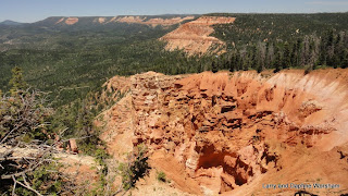
Thursday, June 20 – We loaded up the dog and a picnic lunch drove about 15 miles north to Cedar Breaks National Monument. The Southern Paiute called this area "u-map-wich" . . . ."the place where the rocks are sliding down all the time.”
View from Cedar Breaks Visitor Center
Geology is definitely the star attraction here. 20-25 million years ago a huge basin was formed when areas of the earth shifted. For those missions of years the basin filled with water and sediment. Marine creatures lived, died, dissolved, and the cycle was repeated. Eventually those sediments created the colorful birthday cake-like layers we see today. First glimpsed through the green spruce trees from the highway the formations are dramatic, and no less so when viewed from the many viewpoints.

The next chapter, following all that sedimentation, involved fault movement, uplift and shifting to create mountains, and then volcanic action, sending lava and ash up through fissures to spill over the surface of the strata laid down before. In some places the black basalt boulders are scattered here and there, in other areas the lava flow was so deep and wide it still cannot support plant life, causing the rolling areas covered with the black and broken lava to look like a moon surface.

What an amazing place! At this elevation the temperatures are extreme, and snow and rain take their toll on the softer layers of sediment. Freezing causes cracks, and gravity does the rest. No wonder it’s “the place where the rocks are sliding down all the time.” The scientific description does not begin to describe the beauty of the results. Sculpted cliffs and spires, striking colors that change with the angle of the sun, all framed by trees and shrubs, gnarled and stunted by the harsh climate.

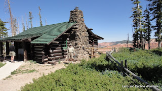
Cedar Breaks was declared a National Monument on August 22, 1933, by President Franklin D. Roosevelt. The monument subsequently benefited his administration’s CCC program, and many of the current buildings are CCC construction.
Cedar Breaks Visitor Center
The visitor’s center, built in 1937, is a stout little log structure position near the rim of what is called “The Amphitheater”, the 2,000 + feet deep canyon framed by the visitor’s center observation windows. There is another really nice structure, just outside the northern park boundary, up on Brian Head Peak. The little shelter provides an amazingly effective windbreak, and an absolutely breathtaking view of the surrounding terrain.

Most of the monument is at about 9-10,000 ft elevation, Brian Head Peak is over 11,000, so “chilly and windy” is an understatement. We passed several patches of snow on our way up to the peak, and marveled at the range of wildflowers we had seen in spite of the chill. The view from Brian Head Peak is worth the 3 mile drive up. It’s not often you can look down on a ski lift!


See a few more photos here.

The weather turned cooler over the three nights we stayed at the Duck Creek campground, and we even had to turn the heater on a few times. We’re in for a shock I’m sure, as now we’re headed down in to Nevada to much lower elevations.

Friday, June 21, 2013

Kanab, Utah


6/18 Monday – Stopped at the RV Corral in Kanab, UT. After four wonderful days at the Grand Canyon, north rim, we’re off in search of more cool weather. The flatlands are burning up right now… literally, in the case of Colorado.

The RV Corral is the newest of the three parks in town.
Home Sweet Home
It’s quite nice, very spacious and clean laundry room, quite a few trees in the parking area, though the spots are rather small…… think boat slips in a marina and you have the picture. The bright yellow-green locust tree we are parked under makes a lovely contrast to the red cliffs right behind us, so at least we have a bit of scenery.

Laundry room and pool area
Honey’s market in Kanab had everything we needed to stock up, including quilt batting! Yeah, onward with my projects!

If you shop at Honey's market save your receipt.  A $25 or $50 purchase is good for a discount at Honey's fuel stop just around the corner. 

Steve found a car was big enough to handle the Enterprise (had to recover from that last day’s tour in the Grand Canyon.) After all the chores were done we went outa Mexican dinner at the highly recommended Escobar’s.  . . good . . not great. Heavy on the garlic and light on the chili. But it was a night out!

Now we’re off to Cedar Breaks, 10,000 fit up. That should be cool enough!

Thursday, June 20, 2013

Grand Canyon - North Rim part IV


Sunday, June 16 – Father’s Day! We had a nice call from Kendra while we were out in the boonies! Technology is wonderful! (when it works!!)
We’d been checking out the park map and admiring the trail to Point Sublimity. Steve asked around about how rugged it was, as it’s posted on the maps as a 4WD recommended. Our campground host offered his recommendation, and we do have 4 WD, so off we went, picnic in hand, not knowing exactly what to expect.  

 The road is well maintained gravel as far as the trail head near the campground, then becomes somewhat more “rustic." The dirt road is at first a gentle grade and open meadow,  then it gave way to more rugged, rocky grade and dense, mixed forest. This certainly would have been a beautiful area in which to have a cabin in the "old days", if there were running water available. It looks from the grasses that in most years there are probably wet spots here and there, if not running creeks.

They work hard here at maintaining the health of the forest, so there is evidence along the way of prescribed burn and thinning. This treatment makes a healthier environment for the ponderosa pines and the aspens, both of which are coming in thickly in the treated areas. Aspen pines ferns and what we were finally able to identify as New Mexico Locust grow in dense profusion. The locust are small trees or large shrubs, and have clusters of beautiful pink-lavender flowers. They grow so thickly in some areas that they remind me of roses or rhododendrons.

There is a view point to stop at along the road, a rocky shelf you can walk out on if you have the nerve. There's quite a view, down, and that may not appeal to everyone. It's hard to grasp just how deep the canyon is, and in many of our photos you can't see the bottom as the angle of the canyon walls blocks it. The antiquity of the canyon is also hard to relate The base layers in this wedding cake arrangement are about 1,840 million years old, the top layer, practically brand new, are only 270 million years old, based on fossils and other geologic evidence.

After driving through dense, mixed forest very much reminiscent of what we knew from Oregon, we turned a corner about ¼ mile from the point and the scene changed suddenly from forest to desert. The ferns changed to sagebrush and yucca, the New Mexico Locust to Cliff rose, and the ponderosa pines to piñon.

We explored the rim and took way too many photos, then had our picnic lunch at one of the tables provided and then wandered around the point looking for more great photo opportunities. It's hard to pass up an opportunity, knowing we probably won't be back here for a long time, even if the distance is still blurred by smoke.

There is a restroom at the final stop, but nothing else along the way so be prepared. The 36 mile round trip takes about 4 hrs and really is suitable for 4 WD only. Passenger cars would be at high risk in many of the rockiest and steepest areas.

The road is very narrow in some places, so remember the proper off-road etiquette, the driver going up has the right-of-way in most states, but, keep your eye on likely places to pull over, or back up to, no matter which way you are going. There are some long stretches where only one car will fit in the lane, and the downhill side is soft and steep.

Steve was very happy with the performance of the Enterprise on this outing. It's the first time it's been off the pavement, and the transmission took to the hills and bumps like a duck to water, crawling smoothly in the toughest spots (had to try out the low range) and the exhaust break doing a great job on the downhill sections.

I only brought home one little souvenir from the day. I thought about coming up with a
story about wrestling a bob cat, or something exciting like that, but I'm not that creative. It's the result of wrestling with a dead yucca. A good opportunity to try out the piñon sap cream I bought last year, and it's done a great job of healing. Other than looking awful, it doesn't hurt at all and is healing quickly.

We made a final stop at the visitor’s center to get a National Park passport stamp in my copy of Brighty of the Grand Canyon, and have a final toast at the Rough Rider Saloon – with a Grand Canyon brewing company beer for Steve, and for me,  my new favorite drink, a “Grand Canyon Sunset.”  More photos of the day's drive here.
Happy Trails….. we’re off to Kanab for a one night stay at an RV park so we can get caught up on a few things, then back out in to the “boonies” again.  We’ll check in again when we have connections.

Wednesday, June 19, 2013

Grand Canyon - North Rim part III

Saturday, June 15 -  we packed a picnic lunch and took the scenic drive along the east side of the park. There are five named viewpoints to stop at, and several trails and viewpoints at each. This was our first opportunity to have a broader view of the canyon, and it left us both speechless (hard to imagine isn’t it!) The first stop is named for President Roosevelt, and there is a plaque placed near the trail commemorating his efforts in having the area set aside as a national park.


The best I can do by way of description is to quote a paragraph attributed to President Theodore Roosevelt from Marguerite Henry’s book, Brighty of the Grand Canyon: 

“The canyon fills one with a sense of awe. Under the naked sun, every tremendous detail leaps into glory; yet the change is startling from moment to moment. When clouds sweep the heavens, vast shadows are cast, but so vast is the canyon they seem mere patches of gray and purple and umber. Dawn and evening twilight are brooding mysteries over the abyss. Night shrouds its immensity, but does not hide it. And to none of the sons of men is it given to tell of the wonder and splendor of sunrise and sunset in the Grand Canyon of the Colorado.”

Though President Roosevelt’s comments reflect largely on the canyon itself, it’s important to occasionally turn around and look at the other side, the rolling plateau, and the flora that populates it. From one view point to another the elevation varies considerably, and we noticed distinct changes in the trees, shrubs and flowers. This is a good time of year here for the plant life. Though it’s dry, the wildflowers are blooming and the woodier plants all look healthy.

We enjoyed admiring the wildflowers and watching the bees work the fragrant shrub and cactus blossoms. Some areas had been cleared by a fire in 2000 and are now filling in with young trees, such features in the landscape tells a lot about the recent history of the canyon. There are also the striking forms of trees long since dead, standing black and gnarled against the clouds and colored layers.

As we worked our way down the tour we noticed the clouds building. First, decorative little mare’s tails, then building to thunderheads, soon showing dark streaks of rain over the other side of the canyon. The shadows increased, and by the time we’d reached the last stop, our plan for lunch, it was growing chilly, dark and windy.

We picnicked on the tailgate and then explored the viewpoint. Soon we were being pelted with icy bullets, and thunder was beginning to roll in the distance. Not being particularly entranced by the idea of meeting lightening at 8,000+ feet, we made the decision to return to camp, and were reinforced in that decision when we saw ice pellets hitting the windshield on our return drive.

It was a long enough day, and we were happy to spend the late afternoon relaxing in camp, thinking about everything we'd seen and ready to plan the next day’s adventures.
More photos here.

Tuesday, June 18, 2013

Grand Canyon - North Rim part II


Friday, June 14 – We drove down to the parking area by the visitor’s center and lodge, then hiked from the parking lot out to Bright Angel Point. Wow! What a view.

Steve on Bright Angel Point Trail
There are several points along the way at which you can see down into Roaring Springs Canyon to the east as well as The Transept to the west.

It’s a spectacular panorama, and even though there was considerable haze due to the fires in Colorado, the colors and shadows created by the many sculpted layers make for an amazing scene. Photos really can’t do it all justice, but we tried!

The trail is only .5 mile round trip, but fairly steep in some places. It’s well maintained gravel, so pretty accessible for most people.

The park brochure says allow 30 minutes, but with time for photos, admiring the view, and listening to the cell phone-delivered tour messages available out on the point it could easily take longer. The altitude 9around 8,000+ plus) takes it's toll on one's ability to walk the steep trail too. We stopped frequently to enjoy the view, and to breath!

Looking down into The Transcept
After the hike we explored the Grand Canyon Lodge, which has some really beautiful and interesting details in the architecture. A multitude of Navajo rugs adorn the walls, and there are hand made wrought iron light fixtures in every room, and most of the woodwork is of huge logs. We have always admired the classic lodge structures, so many of them built in the early 1900's. The original building, constructed in 1928, burned to the ground in 1932. The current lodge was built in 1937 and sits on the original footprint. The view from the dining room is spectacular, preserving the "surprise" intended by Gilbert STanley Underwood the original architect. Visitors do not see over the rim into the canyon until they enter the dining room, where it is framed by the large windows. The same view is available from the terrace, but lacking the "frame" of the window it seems to go on forever.

Bright Angel of the Grand Canyon
There’s a visitor’s center and bookstore next to the lodge, as well as a gift shop. Remembering a book I used with reading groups when working in an elementary school years ago, I picked up a copy of Brighty of the Grand Canyon. Though it’s a young people’s story, it’s fun to reread it in this setting. The story is pretty much based in fact, as Brighty (named for Bright Angel creek and canyon) was a real burrow who lived in the canyon around 1892-1922.

His fame has meant a lot to the area, and there’s a bronze statue of Brighty in the lobby of the lodge. It's displayed with a backdrop of photos of the real Brighty when he lived in the canyon. Petting the little fellow's nose is supposedly good luck, and it seems a lot of visitors have tried it as he has a really shiny nose! He’s quite a celebrity in these parts.
Returning to camp after our tour of the lodge it was time to get Shiner out for a little exercise. Dogs are not allowed on any of the hiking trails in the park except the Bridle Trail. It’s easily accessed via a branch trail behind the amphitheater in the campground, so Shiner got her daily outing that way. It’s a nice, level, wide trail, with no evidence of horses. It runs between the lodge and the North Kaibab Trailhead. We didn’t travel the whole length the first day, saving some for exploration later.
You can tell the wildlife here know they are safe. The Kaibab, golden mantle and ground squirrels sit just out of reach near our camp site and tease Shiner unmercifully. We’ve seen several species of birds, and most of them stay at respectable elevations, but the ravens are a different matter - they strafe the camp site like miniature bombers, just begging her to yank out a tail feather.
In the afternoon our friends from Arizona, traveling on their Harley, met us here in the afternoon. They’d gotten a room for the night in the motel that’s part of the lodge complex. We visited a bit in the campsite, then met up at the lodge for the Grand Cook-out Experience. 

Transportation to the dinner from the lodge is by tram, and it looks a bit like an old steam engine. The idea is to commemorate the history of the park’s development by the SP railway. Both lodges, north and south rim, were built in order to entice eastern investors to come to the west and buy land. (That concept worked pretty well it seems.) There’s a recorded narration of the history of the north rim that “entertains” the passengers on the way to dinner. A large tent is erected behind the Sinclair gas station at the entrance to the campground, and once you are inside they do a pretty good job of setting the western theme.  

 A ranch bbq style dinner served by girls in western clothes and the requisite cowboy hat and dinner is accompanied by a musical show. The entertainers vary during the season, and we were entertained by Woodie and Cleda Jane “The Cochrans.” They’ve spent quite a bit of time in Deadwood, with Woodie playing Buffalo Bill, and he’s pretty believable! They were a good act, performing a lot of western standards with good strong  vocals and some very acceptable guitar picking. We picked up one ­of their CDs after the show, and It will make for some fine sing-along music on the road.
We couldn’t call it an evening without a night cap at the Rough Rider saloon, in the lodge complex. So we ordered up a drink and then slipped out to sit on the veranda at the lodge dining room.

The area was busy, filled with people enjoying the play of the evening colors on the canyon, as well as those chatting with the group hosting the star gazing event.

They had some serious equipment available, and several very knowledgeable volunteers to help visitors use it to view the heavens as the stars peeked out one by one. At dark we packed up and headed back to camp, saying goodbye to our friends, as they will continue on with a whirlwind tour before we see them again in Nevada on July 4.
                                       More photos of the canyon in the album.