Tuesday, February 27, 2024

Davis Mountains State Park

Feb. 20, Tuesday

We've wanted to visit the Davis Mountains area for quite some time. It's one of the few places in Texas with enough elevation to be a bit cooler than the rest of the state when those heat waves hit, and it's also home to a large observatory operated by the University of Texas. This is our first visit to the area, and there's a lot to check out!

During our visit we stayed in the Davis Mountains State Park. The park offers a unique opportunity to experience the natural surroundings and wildlife of this mountainous area both on the trails and on driving tours, enjoy the artistic and rustic handiwork of the CCC's picnic shelters and other structures,  and learn the historic role the area played in the settlement of the area with a tour of nearby Ft. Davis. 

The Davis Mountains campground has a range of campsites to fit different "styles". Some are small, suitable for tents and really short units, others accommodate longer RV's and coaches. Some have only water, others are full service. Maps available on the park's website help sort all that out when making reservations.  There are several sections which makes the camping area feel less crowded than one might think, providing privacy as well as open views of the surrounding landscape.  

The park includes a lodge with restaurant which unfortunately was closed for remodeling and plumbing repairs when we visited. The lodge has an interesting history, having been constructed by the CCC over several years. This article describes the construction phases that resulted in today's very impressive structure. 

The park's other facilities include a small office at the entrance and a small interpretive center located in the campground. Programs are scheduled for some mornings and afternoons but there doesn't seem to be an established schedule so check with office or online. I attended one the program on geology which was very informative, including samples of local stone varieties, geologic history of the development of the landscape we see today, and some photos of examples throughout the park and surrounding area. 

A trail map is available on the park's website, but be aware, it's orientation is completely opposite of the campground map! North is at the top on the trail map and at the bottom on the campground map.)

Wednesday, time to tour the fort!


Nearby Fort Davis National Historic Site is probably the first site outside of the park to visit here as it's such an important part of western history and one of the most completely restored. First established in  1854 " By Lt. Col. Washington Seawell with six companies of the 8th U.S. Infantry, in Oct 1854 for protecting travelers on the San Antonio-El Paso Road". The fort was named for the then secretary of war, Jefferson Davis.  Abandoned by federal troops in 1861, it was then activated again in 1867. The fort was retired again in 1891, and in following years had some private usage which helped to maintain some of the structures.  This is a large facility, spread out over 523 acres. A nicely done visitor center (and gift shop) explains the primary purpose and history of the fort and includes information on the Buffalo Soldiers. 


Some of the buildings are completely restored (or almost so) and furnished with period items, such as the infirmary, others are in various states of repair. Many original structures have largely disappeared (adobe brick will do that over time!) and now only the foundation is visible. 

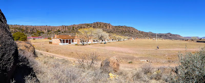
This applies particularly to the stables and other livestock related features that cover a large part of the fort nearest to the main road through town. The full array of the fort structures can be seen from that road (hwy. 17) when on a slight rise. . . or by hiking up one of the hillsides of the box canyon where the fort is located. That's the position from which the panorama above was taken. 


Thursday


The town of Fort Davis, which is immediately adjacent to the actual fort, provides access to groceries and other amenities such as hotels and restaurants. Several businesses are now vacant, or have scaled back services, due in part to the slowdown in traffic during the Covid 19 era. There is a move to renovate several of the hotel properties however, by a group looking to encourage more tourism in the area. 

We did a bit of grocery shopping and then stopped by the county courthouse to admire the grounds and the construction. Texas counties are all rather proud of their historic courthouses, and take steps to keep them well preserved. 

This courthouse was built in 1910 using poured concrete and local stone insets of red rhyolite, a completely different look from other Texas courthouses. It replaced the earlier adobe structure that had fallen into disrepair. 


Thursday

Only a few miles away the Chihuahuan Desert Nature Center and Botanical Gardens is another day trip worth taking. 

A small but interesting Chihuahuan Desert Mining Heritage Museum display is on one side of the parking area. The display features types of ore, all labeled, mining equipment, and some history of mining in the area. The information signs all feature a little burro named Dynamito, the mascot for the association that sponsors the display. It's a nice recognition of the history of mining in the area and harkens back to the days of individuals trekking across the desert with their burrows laden with tools and grub. 

Inside the visitor center is a gift and book shop, and while we were there they also had a good stock of large potted cactus plants waiting for the upcoming cactus sale to be held in March. The host explained the center's features and provided a trail map, so we set out to explore the gardens and the cactus greenhouse. 


I have to say, seeing what they have inside that greenhouse I'm envious, we won't be here for the plant sale and the greenhouse holds an amazing array of the smaller cacti! Many of the plant specimens along the trail are labeled, but as spring hasn't really arrived here yet they are still dormant. The gardens are a good place to observe wildlife too, and there are benches here and there to sit an watch for birds and other small animals.  

Friday
What an amazing day! Today was McDonald Observatory day on our agenda. Other than seeing a few photos of (one of) the large telescope domes we didn't really have any idea or expectation of what to expect. We had as a goal checking the area out for a future trip with our grandsons and daughter. It's definitely on our list now! 


The visitor center opens at noon and we were a little early,  so spent a little time taking the dogs for a walk. We parked at the far corner of the parking lot as we didn't want them to disturb the official greeting party.... the cute little javelina herd that greeted us when we arrive. There were about 10 of them, including one very small young one. Quite tame, they weren't too upset about vehicles, but in fact trotted over to a couple of cars probably looking for a snack. 

At noon we walked up to the visitor's center, we knew we were on time as the giant sundial that covers most of the entry patio indicated we were 8 minutes early. On the dot of noon the doors were opened and we entered to view the displays about the various telescopes and the observatory, and to buy the very low priced tickets for our selected programs. We selected this time to see the solar telescope viewing program. It was very well done and by the conclusion our heads were filled with some unbelievable information regarding the sun, sunspots, galaxies (our own and others) and other fascinating bits of information. We watched current views of the sun, via the telescope, on a huge screen in almost real time. Due to transmission time there's an 8 minute delay. It was a great program!  


At the conclusion we headed out for the self-guided tour of the telescope domes (the option we had selected) and drove up the hill to first one mountain peak and then the other to see the displays and videos offered there. 
The second of the two telescope we visited was the Hobby Eberly. From the website:" It's made up of 91 hexagonal mirrors that form a reflecting surface measuring 11 by 10 meters. The segments must be aligned exactly to form a perfect reflecting surface for good observations. HET is classified as a 10-meter telescope, making it the third largest optical telescope in the world."

Walking around the areas containing the telescope buildings can be a challenge for some as the elevation is well over 6,000 ft. and some of the roadways and walkways are quite steep. There are some terrific views of the surrounding area due to the elevation, great photo opportunities!

The facility is much larger than we expected, and so are the program offerings. There are guided tours, star watch parties, etc. that require scheduling and tickets purchased ahead of time on their website


More photos in the album

TRIP SUMMARY:

33 DAYS
3583 MILES
304 GALLONS OF DIESEL FUEL, AVG: $4.65 GALLON.  AVG. 11.8 mpg
CAMPING TOTAL: $765    FUEL TOTAL: $1415  AVG. COST PER DAY $67.

We stayed primarily in State and County Parks.  Two nights in private campgrounds and two nights in BLM.  The cost of this trip was very similar to last years which was too the same area's.


Sunday, February 18, 2024

Painted Rock Petroglyph Site and a couple of one night stands

 Painted Rock Petroglyph Site and Campground is part of the Bureau of Land Management system. As a BLM campground is had been free in the past, but as with most of their campgrounds they had started charging a nominal fee several years ago. Now they've gone to a new system, which requires the camping registration and fee be handled online. (You can't even go camping these days without needing the Internet for something!) 

We had registered and paid for our site online the day before our arrival, but just our luck, when we arrived it was occupied! The folks who had decided to settle there had no idea they had to pay to stay there! (note to campers..... read the notices as you enter a campground). They graciously left the site and sought one elsewhere. 

We settled in for the evening and enjoyed the uninterrupted view of the desert. Wide open space and no traffic are rare these days, even in the desert. 

Right after breakfast the next day we walked over to the relatively small rocky outcrop that was situated right in the middle of camp! I'm accustomed to having to trek up fairly challenging trails in some cases to see petroglyphs. These are right in our front yard!  

If you are a fan of petroglyphs, all you can say is WOW! In an article about this site Wikipedia states there are approximately 800 figures in this collection. Even if you aren't, the sheer number and variety of glyphs carved here, over several hundred years, is amazing to think about. Some of the older ones are quite faded due to the continued erosion of the rock, and the ongoing patina forming on the stone. (Patina is the dark brown/black layer that forms on stone that is exposed to the elements for long periods of time. Petroglyphs like these are formed by pecking through that layer, usually with a stone tool. In the photo below the glyphs are layered, with the newer ones on top and much more clearly defined than the older, dim carvings underneath

The importance of this area to several cultures can only be understood if you look at a map and understand that the Gila river, which supports wildlife (aka food for native people), the map on the website linked to above shows the early explorer and pioneer trails, and now highways, cuts right through here. So the proliferation of glyphs may be attributed to the number of travelers passing by, or ????  Interpreting petroglyphs is very subjective, and it's fun to imagine why they are here, but no one can be certain they have the correct interpretation. 

In the afternoon I took the dogs for an off-leash walk out to the riverbed, dry at the time but easy navigating. They enjoyed the opportunity to explore at their leisure with no leashes required as we don't get an opportunity for that kind of exploration very often. 

The following morning we departed for a one night stay in Picacho State Park. This is a regular stop for us when traveling to and from AZ or CA.  The photo below is taken from our site looking toward I-10, a very busy highway, with Newman peak in the distance. The highway is far away, and though we can see the steady stream of traffic we never hear it. At night the lights shine so brightly it looks like a diamond bracelet stretching across the valley.


The park has beautiful scenery, an interesting history, and if you visit a bit later in the year, lots of wildflowers. We were two weeks later last year, so there were more flowers in bloom. Check out that post for details.

For the following day, a short drive, a quick trip to the grocery store, and then one night in Kartchner Caverns State Park. This is another favorite as well as convenient stop on the way home. Good trails for walking, the visitor center is really well done, and the cave tours are too. We spent quite a bit of time here last year. That adventure is here.

Next, a long drive ahead of us, to Rockhound State Park, New Mexico. 

More photos in the album!

Thursday, February 15, 2024

Anza Borrego Desert State Park

We packed up and prepared to leave Lake Cahuilla, but delayed actual departure as long as possible, as our destination was only a short drive away and we knew check-in time was 2 PM. Parks often let campers in a bit early, but apparently that's not the case at Anza Borrego. We arrived about 20 minutes before 2 PM and though we completed the check-in process we were told we'd have to go park by the visitor's center and wait until 2:00. So we did, and of course we toured the visitor center too. 


It's nice, and subtly designed to blend with the landscape. The displays are very informative and really well done. Visitors are greeted by a model of a prehistoric bird that's sure to get everyone's attention!

Once 2:00 rolled around we breezed on through the gate and locate our site. We were situated toward the back of the campground, which is on the lower slopes of a steep canyon. We had a view of the the campgrounds various sections as well as beyond into the valley and the nearby town. 

Steve had a real challenge shoehorning the rig into our site. Be advised when visiting here, the roads and sites are all lined with boulders of various sizes. What looks spacious may not have adequate room for tires when backing in longer rigs. In spite of the challenges we were settled in just in time to watch the Superbowl.... the only TV we watched while we were in the park. 


Our site is in the Palm Canyon campground, one of the most spacious and scenic of the loops, and we are quite near the entrance to the trail that leads up to the palm grove in the canyon. There's a small pond at the base of the trail that is apparently home to several types of frogs. Their happy spring songs really added to the evening atmosphere when we stepped out for the night- time dog walk and a little star gazing. 

The plan while here was to meet up with Steve's brother Dale. He camps here often (usually boondocking) and knows the trails and the sites pretty well. I wanted to try out the trail next to us, up into the canyon, so fit that in early, before Dale arrived. 

The trail is smooth gravel at first then quickly becomes a tumbled, circuitous and sometimes steep path of sand and boulders. The official trail is carefully outlined with smaller stones and pieces of drift wood and palm tree that were damaged during a fire in 2020. The park folks here are pretty serious about hikers not stepping off the official trail so they leave no doubt as to where you should step!  


Water was running freely in the creek, which the trail crossed twice, as far as I went. I had decided to be back in camp by 11 AM, so had to turn around before I made it all the way to the palm grove.  

I arrived back at camp just as Dale was arriving..... perfect timing!

After a short visit we departed for touring some of the sites. First stop, Glorietta Canyon.


There are boondocking sites available on the road it. The park has their regulations for that type of camping posted frequently in all the areas where it is allowed. The trail here is a moderately steep, but very picturesque hike. At the moment, shrubs and wildflowers are thinking about blooming, with a few early achievers popping out here and there, but still offering great photo opportunities. 

Leaving Glorietta we continued our exploration out on the flatland at the base of the hills, suddenly out of the sagebrush here were huge dinosaurs all around us. 

They were rearing, lunging and gnashing their teeth! Well, not exactly, but a good suggestion of doing so. There is a long history of life in this desert, and there's a paleontology research center adjacent to the park, so the dinosaurs fit right in.  

The artist who created the statues and the story of how they came to be has been told in detail by others so I won't try. Here's the best rendition I've found, complete with plenty of photos and videos of the amazing work. The link will take you to several years worth of the authors exploration and study of artist Ricardo Breceda's amazing work. 

Next on the agenda, Font's Point, and a truly amazing example of geologic history. East of the town of Borrego Springs, the viewpoint is reach by traveling through a dusty dry wash.


Parking is in a designated area, and there's no clue of the vision that lies ahead. Walk up the sandy path and when you approach the ridge the view suddenly opens up to reveal a view that rivals the Grand Canyon. It's breathtaking to say the least.  The link above provides how to get there and other relevant information, in addition to plenty of photos.

Dale treated us to dinner at Carlee's cafe (wonderful food!) and we all went back to our camps to rest up for the next day's adventures. 

I the morning we met Dale in town an visited the Anza Borrego Natural History gift shop/bookstore and arboretum. They really have a traffic selection of all kinds of gifts and books and the plant collection in the garden has some specimens labeled so was helpful in identifying things we'd been passing when hiking.  Dale headed home, and we went back to camp planning to relax and start packing up when someone announced big horn sheep on the move so we grabbed our cameras and slowly moved over to the hillside directly opposite our site. Wow, we counted eight at one time, but as they gracefully navigated their way across the rocky and very steep slope they certainly didn't stay in an organized group, so we snapped away to get as many views as we could. There are several shots in the album, sorry so many but they are fascinating to watch!


Saturday, February 10, 2024

Lake Cahuilla Veterans Regional Park

Lake Cahuilla Veterans Regional Park   This is part of the Riverside County Regional Park and Open-Space District. If you're looking for outdoor recreation activities in southern California this is a good place to start. (Cahuilla is pronounced "ka-WEE-a")

This picturesque park is older than most we stay in, but well maintained. The sites with utilities are spacious, and there is a range of price, so check the website for particulars. 


There is a spacious boon-docking area surrounded by a variety of desert trees, including palms. It offers a good view of the lake, so that may be of interest in addition to the sites with utilities. It's a nice little lake for fishing, perfect for young children, though anyone would enjoy it. The park offers other amenities too. 


There is a wading/swimming pool at the far end of the campground, with a playground nearby.  There are also game courts of various types, and beyond that area is a "Equestrian and group camping" area. That area is off in the distance behind the palm trees in the lower photo. 


The lake is alive with birds of various types at different times of the year. Right now pelicans and other shore birds are the primary population. There is no swimming currently due to an invasive mussel infestation problem, and fishing gear is inspected for that same reason.


The campground restrooms are clean, and adequate in size as most campers are self-contained. They have 2 coin operated showers. The structures are clean, though it needs a bit of paint and a few repairs here and there. The camp site spaces are large and each has a tree - eucalyptus in most cases, and they are kept pruned up so they don't interfere with the roofs of RV's.        
Depending on your needs, one of the best features is that this park is close in to many of the entertainment related activities that are held in the Coachella valley. We are here to visit family that lives nearby, as it seems many of our neighbors in the campground are here for the same reason. 
According to Wikipedia this lake is prehistoric in origin, and there's quite a geologic record of it's existence, including the changes over time. It was once large enough to extend southward into Mexico. 


 The hills surrounding the are beautiful to watch as the light changes. The deep erosion from thousands of years past create ever changing shadows, and the colors in the slopes change from lavender to deep blues, grays and browns as the sun and clouds shift throughout the day.


The park is named for the Cahuilla tribe. The Cahuilla language is of the Takic division of the Uto-Aztecan family of languages, the most well-established linguistic family of the Americas. The Cahuilla people were the first known residents of the Coachella Valley. In the 1700's the population is thought to have been about 15,000.
Though once considered the smallest Native American tribe in the entire (the tribe was once down to just eight people), the Augustine Band's population is still tiny, with only about 2,000 enrolled members in the various bands linked to at the bottom of the home page under "Tribal Links".           

We enjoyed out stay here very much. It's a quiet, relaxing place to enjoy walking, photography, fishing, or just cloud watching! Our next stop is the Anza Borrego desert! Here's an early morning view of the lake just as we are leaving.


Wednesday, February 7, 2024

White Tank Mountain park and the "Say Hi! Before You Die" Reunion


Feb. 3 - So, we were in space #28 for one night, then we pack up and move "all the way across the road" and up one space to #25. It sounds like a "piece of cake", but in reality it's almost as much work as moving all the way across the park! 

All settled in to space #25 now, it's our home for the remainder of our stay in this area. We've a beautiful view out across the desert toward Glendale and Phoenix, where the city lights sparkle like diamonds at night. 


Last year's posts on the campground and the petroglyphs provide more information about the park itself so I won't repeat all of that. You can find them here. . . . 

White Tank Mountain Regional Park  and, Petroglyphs 

Once settled into the new site we headed back into Glendale for the remainder of the reunion activities. We left the pups to guard the trailer again. We don't usually leave them alone for very long, but this will be a few hours, so we want to know how they're doing. We have a Ring camera set up to keep track of them (and to be sure they aren't barking) when we are gone, so no worries about annoying the neighbors. It seems they both enjoyed a healthy nap all the time we were in town. Other than their dinner being a little late a couple of the days we were out I don't think they cared too much about our absence. 

The reunion was a huge success. 
It was a slightly larger group than last year, and our host and hostess had arranged everything to perfection, right down to the cookies sent home with us as souvenirs of the gathering. (Not only beautifully made, they tasted good too!)

These folks all worked together in California, for the Orange County Sheriff's Department, starting back in the late 1960's. 


It's great to see them connect each year and swap remembrances of the work they did, and everyone enjoys the clearly embellished versions of stories re-told each year when they get together!

Once the reunion activities had concluded we scheduled the necessary errands and some time to enjoy the park. 

The wildlife in the park is plentiful. We caught the motion of a couple of chipmunks scuttling beneath the shrubs, and during the early morning and evening walks with the dogs we hear coyotes celebrating their breakfast catch. One evening and again early in the morning we heard them singing in celebration of an early morning catch. It sounded like there were several in the group, including young ones. 

The birds are plentiful too. So far my Merlin app has identified the songs of Cactus wren, Curve-bill thrasher, Gambel's quail and House finch. 

Before the previous occupants of our site moved out I noticed that they had put up a black seed feeder, so I wasn't surprised when the Gambel's quail showed up every morning to continue searching in the fine gravel for those tasty seeds. I also noticed that one plump hen spent time up on the picnic table while the others searched for the seeds. Do they post a look-out?

In our walks around the park we noticed that the recent rains had brought forth a flush of seedlings foretelling of a good wildflower year. Not much was blooming yet, save for the ever durable creosote bush and one really ambitious mallow bush. Even without flowers, there is color everywhere, especially after the brief rain we had. The barrel cactus's pink thorns are almost as bright as flowers, and the variety of forms the saguaro take are always amusing. They almost look human!. 

Stepping out the door after the overnight rain we were met with the wonderful fragrance that can only be described as desert perfume. The moisture on the desert sage, mesquite and other shrubs activates their sweet scents and they blend beautifully. After enjoying this most of my life, I just learned there is a name for it. It' called petrichor  (pronounced peh-truh-kor)

Most of the landscape in this park is composed of granite of one type or another. 
Some is largely quarts, some contains more feldspar, each type is a different color so there is a variety of tones, especially after a rain when the moisture brings out the color. 

From black to white, and red to green, and then there are those stones filled with so much mica that under the bright sun they sparkle like gold. It's no wonder several Spanish explores went back to the king and told him there was "gold everywhere, just laying on the ground".  You may have to click on the photo to open it up in a larger size to really see the sparkle. The white sample lower right is what the "white tanks" in the mountains were created out of, through erosion, over time. 

There is no official "visitor center" as such here. There is a gift shop/nature center attached to a branch of the county library right at the entrance to the park. 

They have some information on the surrounding area, a few displays of snakes and other interesting desert dwellers and are able to answer questions. One unique display was the juvenile "speckled rattlesnake", this one was white, though they come in other colors.  

The Library welcomes visitors who would like to browse their collection, sit awhile and read a magazine while enjoying the view out their windows to the mountains, and they can also point toward useful resources for answer questions. 

Errands completed, sight-seeing and chores done, we packed up and prepared for departure. Next stop, La Quinta, CA, to visit family for a couple of days. 


Monday, February 5, 2024

Skyline Regional Park - Buckeye, AZ

The current popularity of RV camping has really put a crunch on the ability to schedule a multi-night say anywhere these days. We often have to piece it all together to make a lengthy stay in a single area. Such is the case when planning for our reunion event. We needed 5 nights in a row in the White Tank Mountain Regional Park. It seems that wasn't possible, so the patchworking began. 

Feb. 2 - First night in the area, Buckeye's Skyline Regional Park.


This is a fairly new park and isn't on a lot of lists for the area. It's an 8,700 acre mountain preserve located in the southern White Tank Mountains. It's situated just outside of Buckeye. 

When we arrived we were delightfully surprised to find one of the most spacious campgrounds we've ever seen. Each site is easily 4 times wider than sites are in many other places. There are only a few sites, but most are adequately deep to accommodate even the largest rigs, and the access road is wide enough to make backing in easy. 

In the photo at the right you can see our rig way at the back, in the center of the photo.

There are multiple hiking trails, all well marked, and lovely desert scenery too. The park is open for campers, hikers, bikers and horseback riders. Clear signs list special trail instructions for each group in the few areas where it's necessary ( i.e. no horses on the bridge).

In the afternoon we head into Glendale for the "Say Hi before you die" reunion activities (a little dark cop humor there), a 30 minute drive away, leaving the pups to guard the trailer. 

This first evening was casual with a delicious spaghetti dinner, time spent getting reacquainted with people we hadn't seen for a year, or more, and an early "to bed" for everyone who had traveled to the event.

One little, very important, detail.... this is a "boondocking" RV parking situation - that is, no power and no water, you'll need to be prepared for that. We're used to coping with cold weather and all the other "opportunities" when we travel, so it's not a problem, but it might be for others. This park has very nice restrooms, but no showers. 

No electricity meant no heat all night while we were asleep. We were very comfortable though, having used our propane heater before going to bed. 

The dogs however, had a different opinion. "What do you mean we have to go outside? It's cold!"

If you are interested in using the hiking trails be advised, a lot of other people are too! We noticed the parking lot filled to near overflowing very early in the day on Saturday, and mostly cleared out by dusk. 

Park entrance is free for day use, and you can rent a campsite via their website. Currently (2024) the price is $20 per night. 

Time to move on to another nearby location. 

Feb. 3 - So, one night taken care of in Skyline, now we need 4 more. We move to White Tank Mountain Regional Park, space #28 for one night. 


Sunday, February 4, 2024

Adventures in Goldfield and the Superstition Mountains

Lost Dutchman State Park is named for the famous "Lost Dutchman mine". This story has been developed over several generations of treasure seekers, and began actually during the Spanish occupation of the area. It is a fact that a land grant was issued in 1872 to a man named Peralta. From there, it's hard to tell fact from fiction. The legend has evolved over 152 years to include unsolved murders, forged documents, shifting locations, Apache Indians, and anyone connected to the infamous Spanish-Mexican Peralta family as well as two (or more) German immigrants. Several books have been written either entirely on this mine and legend, or at least including it in the overview of other lost mines. One good source is the book Lost Bonanzas, by Harry Sinclair Drago (1966). The book contains the stories of lost mines in 7 western states. The Lost Dutchman mine has inspired hundreds if not thousands of treasure hunters, and historians interested not only in the mining aspect but western history. No surprise, there is a Lost Dutchman Mining Association. It's a part of a larger organization. Check out the blog at Gold Prospectors Association of America. They have educational opportunities for folks interested in learning about the hobby and an occasional "annual" rendezvous that looks like a great opportunity to meet other hobby miners.

Wed. Jan 31 - Arizona is famous not only for it's beautiful blue skies, amazing clouds and rock formations but for the many mining operations it has supported over the years. Goldfield (in Arizona, not the one in NV) was one of those mines. This settlement/attraction is only a short distance from the park so our exploration started there. 

The buildings have been maintained and restored nicely, filled with shops of various types, and offering everything from snack to full meals in the saloon where dance hall girls will deliver your your order to your table.


The ceiling of entrance to the saloon is adorned with hundreds of pairs of boots. 

We never found an explanation for the tradition, but it beats business cards for atmosphere!


Across the street from Goldfield is the Superstition Mountain Museum and gift shop. The small museum is a good source for local information and history, as are the many books on local topics that the gift shop has in stock. There are buildings around the grounds that relate to the local history too. One is the Elvis Chapel that was featured in an Elvis Presley movie. They offer very popular free lectures on relevant local history and other aspects of the area every Thursday. The recent one, on a local amethyst mine, included a discount on amethyst jewelry. You should have see the overflow in the parking lot!

Thursday, Feb 1 - We aren't here to look for the mine, that's for sure. But viewing the landscape that figured largely in the history of it is fascinating.


A rock formation known as "Weaver's Needle", for instance, was one of the few stable landmarks used as a clue to the mine's location whenever it was described. 

We took a day trip on the Apache Trail (Hwy 88) as far as Canyon Lake and then east to Tortilla Flat. About half way up we had a chance to view the "needle". The small peak to the right in the photo is the far-away "needle", looking like a dollop of whipped cream. 

It is a part of the larger Superstition Mountains formation (plural - as opposed to The Superstition Mountain where we are camped). From a distance it doesn't look very imposing but as a landmark it's useful as it's isolated and easily seen. The difficulty is, how far from the needle formation, and in which direction is the mine? The needle is visible from quite a distance leading searchers to wander over hundreds of miles of rocky, arid desert land. 


The Apache Trail (Hwy 88) was established first as a footpath/horse/stagecoach road. it is a really narrow, winding road with some pretty amazing switch-backs. It would take us past three lakes if we choose to go to the end, but that's not even possible currently, as landslides closed the whole road in 2019 when storms caused flash flooding. A post on the Watson's Wander blog from 2013 has a good map of the original road and some photos from Tortilla Flat. The half of the road closest to the park is open now, so we were able to visit the historic settlement of Tortilla Flat. (Not the related to Steinbeck's book, or the movie, which are based in California). 


The historic site was at one time a stagecoach stop, and has now been in continuous operation for over 100 years. 

Tortilla Flat has burned to the ground at least once, and been totally flooded at least once, but still it survives. At one point it served as a supply source for the development of the dams, now it serves primarily tourists and those who have boats of various sorts at the marina at the edge of town. More of the history is here in a Jan, 2024 article

Now, the town is a peaceful tourist stop. The residents of Tortilla Flat have taken good advantage of building on their history. There's an old time photography business alongside the small museum, a saloon offering meals, and of course, the largest business in town has a variety of snacks and souvenirs.

Resident Sheriff Karen and the mayor keep the peace.


A friendly, laid-back sheriff greats visitors on the sidewalk and keeps the peace with her ready sidearm (a fully loaded squirt gun!). Other period costumed cowboys and dancehall girls wander the streets, creating an atmosphere of having gone back in time. 

The nearby marina on Canyon Lake offers scenic boat tours on the Dolly Steamboat so visitors can learn more of the area's history while enjoying the scenery. 


The reunion we're headed for happens in Glendale, Arizona so we pack up in the morning and head that direction. Stay tuned!


Friday, February 2, 2024

ON THE ROAD AGAIN!

ON THE ROAD AGAIN!......Sunday morning 1/29 about 10 AM we left Rockhound State Park and headed west on hwy. 10, then north on 191 to the little town of Safford and our nearby destination, Roper Lake State Park. We stayed at Roper last year and really enjoyed it. The views are beautiful and there are some good trails available to explore with the pups.   

As we rolled down the road we remembered that several years ago Steve had seen a posting on an RV discussion board for job opportunity in the area we were passing through. It was a "help wanted ad" for someone to help with the construction work of restoring a ghost town. The posting included an opportunity for someone to organize and index documents related to the town. It would have been right up our alley, but we still had jobs at the time. Steve said he remembered hearing the man who owned the town had been murdered a few years ago. Our route took us right by the location so we stopped there for lunch and to check out the town itself. 

The town is situated on a narrow strip of land in between Hwy.10 and the railroad line, past which there are dirt roads leading out into the desert. 


The "ghost town" of Steins (or Steens) is a small collection of buildings and adobe ruins, some in their original locations and others having been moved in or reassembled in the spaces between. The Wikipedia article provides the historic background. 

The area is now fenced, and looks very neglected, so photos had to be taken from the outside of the area. The town location is actually right on the highway, and traffic is busy these days, so it's tricky to get a shot with no trucks in the background. 

Unfortunately, between the fence and my short stature I couldn't get decent photos that weren't covered just rooftops covered in sagebrush, so try an areal view on Google maps. You can click on satellite in the layers choices and then zoom in to get a better idea of what is actually in the little town. 


Legends of America has the backstory of the town's current state and the story of the attempted restoration is intriguing. It seems we have a second murder mystery on this trip!


We arrived at Roper Lake State Park about 2 PM and settled in to the same spot we'd been assigned for our last visit. We have a perfect view of the mountains and the snowy cap on the highest peaks made for beautiful contrast. 

These are the   Pinaleno Mountains.

The name of the range reflects the pine trees growing on it's slopes. They make for a very picturesque background with the shadows constantly changing with the movement of the sun, and the glistening snow on Mt. Graham. 

We enjoy this campground for many reasons. The scenery is one reason, the trails another, and it's really quiet. Though fishing is allowed here, this time of year there doesn't seem to be much of that activity, and it's still chilly so the birdwatching is at a minimum too. The lake and the picnic area on the little island that extends out into it make for a nice viewing area. The park is popular pretty much year round, and based on difficulty getting reservations it must be full every night. As with all campgrounds anymore reservations are a necessity. 

We pull out this morning, we'll be moving to Lost Dutchman State Park for our next stop. 

The three hour drive to Lost Dutchman State Park wanders through Apache land, several small towns, and some beautiful scenery. 

The rocky formations in this area are not only beautiful, they are rich in minerals. We passed several large copper mines, and then the Magma Mine, originally named the Silver Queen. 

This is the deepest mine in the state. There are 36 levels, with levels every 100 feet in the upper 2000 feet, and then every 2000 feet apart down to 4800 feet. The article linked above provides the history of the mine. 


We arrived at our site in Lost Dutchman State Park around 1:30 and wasted no time getting settled in. 

A cactus wren perched atop a cactus and welcomed us to the neighborhood with a song, and there were humming birds darting about in the shrubs. What a lovely beginning to our stay!

Our site is nestled up against the rocky slope at the base of Superstition Mountain and we have a terrific view of saguaros and other native vegetation. The site has a short path leading directly to the trail that encircles the park. 

The view out our door is perfect. Due to the way the sites are laid out we have a clear view of the mountain behind us, with no interference from other camp sites.


We spent the afternoon getting settled and trying out some of the many trails around the park. Everywhere you go there are striking scenes of giant saguaros, bushy cholla cactus and red mountains with fascinating erosion patterns. There was a bit of haze in the air, but as the sun moved and changed the shadows the effect was still fascinating. 

We'll do a little exploring in the area tomorrow, so tune in again for that report.