Showing posts with label Ghost towns. Show all posts

Friday, February 2, 2024

ON THE ROAD AGAIN!

ON THE ROAD AGAIN!......Sunday morning 1/29 about 10 AM we left Rockhound State Park and headed west on hwy. 10, then north on 191 to the little town of Safford and our nearby destination, Roper Lake State Park. We stayed at Roper last year and really enjoyed it. The views are beautiful and there are some good trails available to explore with the pups.   

As we rolled down the road we remembered that several years ago Steve had seen a posting on an RV discussion board for job opportunity in the area we were passing through. It was a "help wanted ad" for someone to help with the construction work of restoring a ghost town. The posting included an opportunity for someone to organize and index documents related to the town. It would have been right up our alley, but we still had jobs at the time. Steve said he remembered hearing the man who owned the town had been murdered a few years ago. Our route took us right by the location so we stopped there for lunch and to check out the town itself. 

The town is situated on a narrow strip of land in between Hwy.10 and the railroad line, past which there are dirt roads leading out into the desert. 


The "ghost town" of Steins (or Steens) is a small collection of buildings and adobe ruins, some in their original locations and others having been moved in or reassembled in the spaces between. The Wikipedia article provides the historic background. 

The area is now fenced, and looks very neglected, so photos had to be taken from the outside of the area. The town location is actually right on the highway, and traffic is busy these days, so it's tricky to get a shot with no trucks in the background. 

Unfortunately, between the fence and my short stature I couldn't get decent photos that weren't covered just rooftops covered in sagebrush, so try an areal view on Google maps. You can click on satellite in the layers choices and then zoom in to get a better idea of what is actually in the little town. 


Legends of America has the backstory of the town's current state and the story of the attempted restoration is intriguing. It seems we have a second murder mystery on this trip!


We arrived at Roper Lake State Park about 2 PM and settled in to the same spot we'd been assigned for our last visit. We have a perfect view of the mountains and the snowy cap on the highest peaks made for beautiful contrast. 

These are the   Pinaleno Mountains.

The name of the range reflects the pine trees growing on it's slopes. They make for a very picturesque background with the shadows constantly changing with the movement of the sun, and the glistening snow on Mt. Graham. 

We enjoy this campground for many reasons. The scenery is one reason, the trails another, and it's really quiet. Though fishing is allowed here, this time of year there doesn't seem to be much of that activity, and it's still chilly so the birdwatching is at a minimum too. The lake and the picnic area on the little island that extends out into it make for a nice viewing area. The park is popular pretty much year round, and based on difficulty getting reservations it must be full every night. As with all campgrounds anymore reservations are a necessity. 

We pull out this morning, we'll be moving to Lost Dutchman State Park for our next stop. 

The three hour drive to Lost Dutchman State Park wanders through Apache land, several small towns, and some beautiful scenery. 

The rocky formations in this area are not only beautiful, they are rich in minerals. We passed several large copper mines, and then the Magma Mine, originally named the Silver Queen. 

This is the deepest mine in the state. There are 36 levels, with levels every 100 feet in the upper 2000 feet, and then every 2000 feet apart down to 4800 feet. The article linked above provides the history of the mine. 


We arrived at our site in Lost Dutchman State Park around 1:30 and wasted no time getting settled in. 

A cactus wren perched atop a cactus and welcomed us to the neighborhood with a song, and there were humming birds darting about in the shrubs. What a lovely beginning to our stay!

Our site is nestled up against the rocky slope at the base of Superstition Mountain and we have a terrific view of saguaros and other native vegetation. The site has a short path leading directly to the trail that encircles the park. 

The view out our door is perfect. Due to the way the sites are laid out we have a clear view of the mountain behind us, with no interference from other camp sites.


We spent the afternoon getting settled and trying out some of the many trails around the park. Everywhere you go there are striking scenes of giant saguaros, bushy cholla cactus and red mountains with fascinating erosion patterns. There was a bit of haze in the air, but as the sun moved and changed the shadows the effect was still fascinating. 

We'll do a little exploring in the area tomorrow, so tune in again for that report. 


Friday, August 2, 2013

Black Range Tales, a book review

These are the stories of James A. McKenna, or "Uncle Jimmy", as the community came to know him in his later years. Uncle Jimmy's stories of his life and adventures are unique little windows into a time long past. There is no bragging here, no attempt to write a wild, shoot-em-up adventure story. These are true tales of Indian wars, mining adventures, the miners and gamblers, theives as and good and honest folks. Real life, as the pioneers lived it, in the natural, colorful language of the time.

Set in the Black Hills of New Mexico, those familiar with the state will recognize the names of many of the mines and settlements still on the map. Silver City is at the center of the area where most of the stories take place. Mines, both lost and well known figure largely in his tales, as well as many mining towns no longer in existence. The geographic and geologic details of mining camp locations make the book a great resource for ghost town hunters.

Born in Pennsylvania in 1951 Uncle Jimmie began working his way west at an early age. He did it the way most folks did at the time... a little trapping, a little herding, a little working on the riverboats. He landed in the southwest and settled in  prospecting for silver and gold, as the area was heavy with mining opportunities. When he wasn't prospecting he serving as a justice of the peace, or any one of his many other roles. Along the way he met some pretty fascinating folks. In delicious detail Uncle Jimmy tells of surviving battles with Indians, near misses in mining accidents, hunting bear and dealing with the shysters attracted to the easy money of a mining community. Many of these fascinating characters, like the fellow members of the Spit and Whittle Club, helped him tell the stories. All together, it's a captivating read, especially so if you happen to be familiar with the area and can envision the rugged landscape he describes.

This edition (1969) has some improvements over the first edition, published in 1936. Updates include a map in the front that covers most of the locations mentioned in the stories, and the addition of an index. The index is fairly complete, and would certainly be useful for referring back to stories for details on specific mines or individuals mentioned. Even better, the text has been scanned and is available as a completely searchable document on Ancestry.com, for those with a membership to that service. Search Black Range Tales.

Black Range Tales, chronicling sixty years of life and adventure in the Southwest.
James A. McKenna. The Rio Grande Press, 3rd edition, 1969
The book is available from several retailers, and as it has been reprinted several times, check closely to see that your edition includes the index and map. The book is not available in electronic format, other that the source mentioned above.

A big Thank You! to David and Stephanie Nishikida for giving me a copy of Black Rock Tales!

Thursday, July 18, 2013

Cave Lake and the Charcoal Kilns

Wednesday, July 10, 2013
Cave Lake State Park is just a few miles east of Ely. We stopped here, at Elk Flat campground, in the past (see that post) and had a good experience so decided on a repeat visit. We like Elk Flat campground, as the spaces are widely separated with the juniper trees providing considerable privacy. Ely is close enough to run in for groceries and other necessities which is nice if staying for several days.

Thursday was the day for exploring. We took hwy.50 (hwy.6) north just a few miles to the turnoff for the Ward charcoal kilns historic site. 
Cave Valley Road leads to the kilns, where you turn off at the sign for the Willow Creek Trading Post.

You'll find charcoal kilns like these at many locations throughout the west, as in pioneer times charcoal was an important fuel used in mining and metallurgy industries. 

The process was long and complicated, involving 35 cords of wood cooked through a special process for 13 days for each batch produced. 

The active mining area here required so much charcoal the surrounding hillsides were almost completely stripped of trees by the time the mines petered out.


These particular kilns have weathered the years quite gracefully, perhaps because of their remote location and the generally dry weather. 

Now, with desert shrubs softening their edges and colorful lichens growing on the stone blocks, they are interesting relics of a time long past. The skill in stone masonry required to build the kilns is to be admired.  


Willow Creek runs past the kilns, and though the area is largely sagebrush, the creek itself is lush with grasses, mint and pennyroyal, which sent of a wonderful aroma when Shiner went down to check out the fresh water gurgling under the little footbridge.

If you're looking for an out-of-the-way place to camp, Willow Creek campground, near the kilns, is attractive, with generous sites and thick stands of juniper and pines between them. And it was completely unoccupied! 

Each site has a covered picnic table, and there’s a smallish group site available. There’s also a picnic area halfway between the kilns and the campground with two tables and restrooms. 

Leaving the kilns we backtracked to the Ward Mining District turnoff. As the term "district" indicates there were, and are, several mines here. Some are still in operation and not open for exploration. The actual Ward town site is at the upper end of the road, past the cemetery.

The Ward Cemetery is an interesting place to explore. An information sign board at the entrance tells the history of several of the individuals and families buried there. Several ornate markers still stand, a few plots are set apart with wrought iron fences, but most of the graves are protected with simple wooden fences. Many are unmarked now, the names and dates lost to time and weather. 

There isn’t much left of the town now but a few stone foundations, though more can be seen if you hike out among the sagebrush. As the temperature was dropping rapidly and we were being pelted with icy raindrops we passed up that opportunity in favor of continuing our tour on the road. 


At the end of the road there's the remains of a mining operation and a few metal structures surrounded by colorful piles of tailings.

We returned to our campsite by the alternate route, taking the cutoff east from the charcoal ovens site back to hwy 50 (this would be the southern entrance to the kilns from hwy 50). This road is shorter (3 miles less of gravel) and with less noticeable washboards than the northern route. If towing a trailer in to the campground at the kilns we’d definitely recommend this route. 

Elk Flat is definitely a dog-friendly place to stay. Surrounded by wide-open spaces there are opportunities for hiking in all directions. Shiner and I headed for a nearby ridge for this view of the campground.

Our campsite as seen from a ridge to the NW of the campground
Elk Flat campground is situated high up on a ridge so there are nice vistas from several of the sites. Many of the sites will accommodate our length so it's easy to find a space, and there’s a restroom with showers, as well as an RV dump.

Cave Lake
The Lake View campground, higher up, is nice, but steeper, tighter and designed more for fishing and boating visitors.There's usually more traffic there, which means more dust too. The sites are higher up than the lake, affording a nice view from many of them. 

All things considered, this is a nice state park for those who like to hike (there are several trails) fish, boat, or just relax!

Cave Lake State Park and environs album here.

Saturday, July 23, 2011

Green River, UT

Our neighboring camper at Nine Mile Ranch invited us to share his campfire one evening and as we got acquainted we discovered we had a lot of interests in common. An experienced desert rat himself, he suggested several sites he thought we'd enjoy visiting. One, Sego Canyon, was easy to fit into the schedule as it's only 25 miles east of Green River, where we'd planned to spend the next couple of days.

We arrived at Green River State Park just about lunch time and were quite surprised to find it completely empty, except for a handful of rafters milling around the put-in area. The campground is really nice, and so green it seems merely an extension of the golf course that is attached. There are no hook-ups, but water is available and as long as there are sunny days our solar panel keeps cranking out the the electrons so we're in good shape. The restrooms here are really nice too, which I'm sure the tent campers appreciate.

Evening brought a classic thunderstorm. The air went from totally still to blustery and wet, with some amazing lightening. The storm produced quite a bit of water, as we saw the next day when we were out touring. When they warn about flash floods in this country, pay attention!

Thompson Springs Motel
We left right after breakfast for Sego Canyon. It's east on Interstate 70,  about 25 miles to the Thompson Springs exit. Thompson Springs was an active railroad town at one time but now, like many railroad towns, it's now pretty much abandoned. The brick building that was a cafe still has the counter and other furniture inside, and there an old metal chair outside the hotel, looking as if someone just got up and went inside.

To get to the rock art, go north past the old Thompson Springs school. It's about 3 miles to the rock art site. There's a restroom there, and a picnic table with no shade.

This site is fantastic! Plenty of interpretive signs if you aren't knowledgeable about the subject, and easy to navigate trails for good viewing angles. Everything is near the road so hiking isn't a requirement.

Panel at the old corral
These examples of Ute, Fremont, and Barrier style rock art are amazing, some of them dating back thousands of years. The site itself is beautiful. The drawings cover towering cliffs that have fascinating shapes and mineral stains that look almost like paintings. When I noticed the area is an alcove it reminded me of research done by Steven J. Waller on the acoustics of rock art sites. He has done considerable research on the acoustic effects of rock art sites, and theorizes that some of the sites may have been chosen specifically because of the echos produced there.

Panel at the picnic areaa

Unfortunately there's been a good deal of vandalism here. I'm glad we were able to see these areas before there's even more destruction.

If you aren't into rock art, how about a couple of ghost towns?

Oven at the old homestead
Drive on up past the rock art site taking the left fork in the road into Thompson Canyon, where you'll find the remains of two dug-outs and a brick oven with a roof over it.

This was a cozy little enclave in early days, known as the Stortini farm, and they used the oven to bake bread, storing food and other items in the stone dugout according to reminiscences of their granddaughter.

The Thompson Canyon road doesn't go much past the farm, so turn  around and go back to the fork you passed on the way up, it will take you to the town of Sego. You'll pass the cemetery soon after the fork. We found mention of the Stortini family in the graveyard. There may have been more than one grave belonging to the family as many aren't marked. Someone has tended the graves recently, forming crosses of stone and leaving artificial flowers. Actually, only a few graves are identified, and several look like the classing "cowboy grave", just mounds of dirt and rocks.

All that's left of Sego
Travel a bit further on past the cemetery to the ruins of the town of Sego. There's not much left now, just a couple of stone buildings and the collapsed wooden boarding house. There's a nice big cottonwood to picnic under, and plenty of chunky black coal drifting down the hillsides to demonstrate why the town was here in the first place. Coal mining provided jobs for a good many people in the canyons from 1911 to the early 1940's. A special rail line was built up to the mine to accommodate shipping of the coal, but when water and other expenses started to become an issue the mine was shut down. It opened up again a couple of times but due to labor costs and other issues the owners really struggled to make a profit.

When the railroad line to the mine was abandoned in 1950, the owners of the mine owners constructed a truck ramp in Thompson to load coal directly into the railroad cars. The ramp and much of the grade still exists, as well as a couple of the trestles, but they trestles are in a dangerous condition and cannot be crossed.

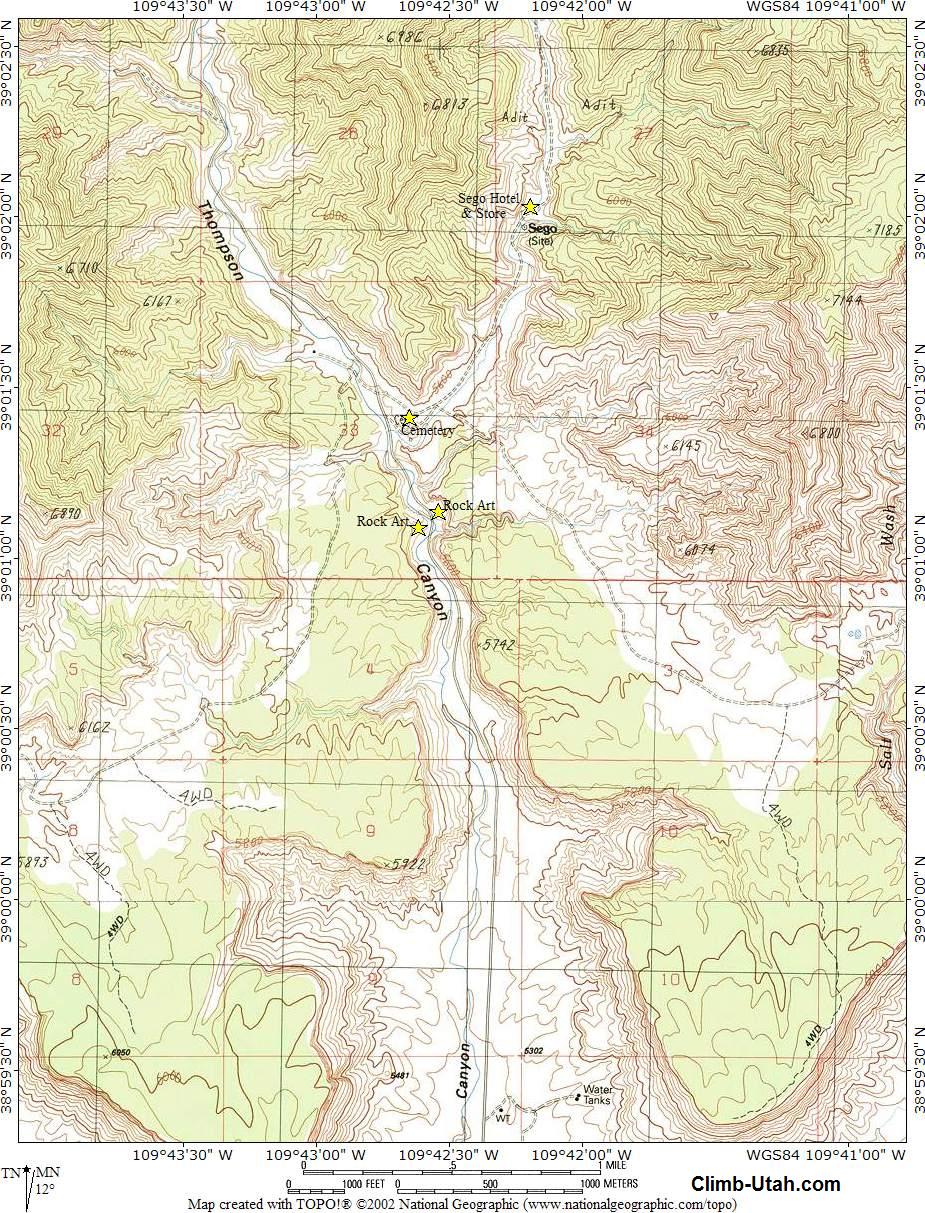
There's more about the ghost town of Sego in Wikipedia, and Kathy Weiser's article here. Link to a topo map of the area here.

What a day! Hard to fit in the blogging when there's so much adventuring to do! Before we left Green River we had one more stop to make - Ray's Tavern, also recommended by our camper friend.
'Best burger and brew we've had in a long time! If you're in Green River, stop in!

Check the album for more photos.

Tuesday, July 19, 2011

Nine Mile Canyon, UT - Part I

Nine Mile Canyon had been on my "bucket list" for quite a while, as it is an area known for some great rock art, and since it was "on the way" after leaving Park City we planned a few days in the area.

The canyon is truly a study in contrasts. Here, you can experience the very old and the very new, the quiet of narrow canyons and small gurgling streams, and the hustle and bustle of the natural gas industry and ranching.

Formed by layers of lake mud compressed over the eons, the sides of Nine Mile Canyon are built of layer upon layer of mudstone, shale and sandstone. Richly colored and sculpted by erosion, they are fascinating scenery and would be the perfect backdrop for a western movie. The towering sides rise to over 7,000 feet, more than 1,200 feet above the valley floor. The dramatic and awe inspiring  view alone is worth a trip to the canyon.

Over a span of about 8,000 years many successive cultures have called this area home. The earlier are grouped together under the term “Fremont Culture”, later the Utes roamed the hillsides. Following closely after them were pioneer settlers and a few world-famous cowboys and “bad guys” like Butch Cassidy and the “Wild Bunch”, as well as the U.S. 9th Calvary (Buffalo Soldiers). Truly a microcosm of western history, there's a lot to explore in this narrow canyon.

Early ranchers established grazing areas for their cattle and judging by the ruins we can still see today they built some pretty impressive buildings and holding pens. Many of the homesteads were built up against the rocky cliffs, for a bit of wind protection perhaps. Most of those  old ranches now stand forlorn and forgotten, roofs caved in and doors hanging ajar, but nonetheless protected by law from destruction, as is the rest of the canyon.

The canyon doesn't seem lonely, however, as the various pipeline operations and working ranches generate a considerable amount of traffic, in addition to the tourists moseying along the road checking out the petroglyphs and scenery just as we were. There are still a few working ranches here, and cattle seem to think they own the road, but the picturesque abandoned ranches far outnumber the occupied ones.

You might say Nine Mile canyon is remote, if you consider its lack of services, and the approximately 22 miles one must drive to find a store of any kind.

There is no cell service here, no mail boxes, no newspaper delivery, but there are deer and a rushing creek, and those fantastic sandstone spires contrasting with billowy clouds, petroglyphs and Fremont culture ruins and pioneer cabins provide enough entertainment for us.

Nine Mile Canyon is actually about 40 miles long, the name coming from early days when John Wesley Powell was exploring the area. There are several side canyons worth exploring if you have the time and inclination, but plan for several days here in order to do so. The tour guides say you can “do it in a day”, but it took us two, and we didn’t get to everything we had intended to see, much less any of the inviting gravel roads leading off into the narrow side canyons.

Natural gas plant on the left
Several petroleum companies have been operating in the canyon for many years, and there have been some emotionally charged conflicts between them and the conservationists who seek to protect the petroglyphs, Indian ruins and historic pioneer buildings from the ravages of the dust and fumes produced by vehicular traffic. Dust, which damages the petroglyphs, is the major complaint.  Some compromises have been reached.  There are paved sections in some areas, and in others magnesium chloride is sprayed on the road as a dust inhibitor, though experience and research is now showing there are drawbacks to this treatment too.

Some sections of the road have been routed further away from petroglyph panels to give them a little more protection from dust and fumes.  As usual with compromises, probably neither side is totally happy but all the final ends are accomplished. . . jobs, energy, preservation, and access for the public.  We are just grateful for the opportunity to visit the area and appreciate both the need for energy and the need to preserve historic areas. We also noted that the roads used by the petroleum companies tend to be better maintained than in other areas, another bonus for travelers.

This canyon is famous largely for the petroglyphs, the number as well as the style. We'll share more about those in the next blog post. The younger, pioneer history is important too, and definitely worth experiencing.

The ghost town of Harper, as well as Nutter Ranch, are both locations with a number of standing buildings. Harper once had a stage coach stop, inn, school and postoffice. Now, mere shells of those buildings remain.

Much of the property along the canyon is privately owned, so watch for signs and respect them. It’s easy to get good photographs without trespassing (or annoying the cows).

Gate Canyon intersects Nine Mile Canyon at about the halfway point. Named for a stone arch that went over the road back in stagecoach days, the arch was demolished because of fears it would fall and crush the stagecoach or other travelers who passed beneath it.

Outlaw Point
Gate Canyon is also the location of “outlaw point”-
"Outlaw Point" is the sharp bend in the road where a group of outlaws intended to ambush the soldiers escorting the army payroll and Indian annuities.  The plan was to kill all 20 soldiers in the escort and leave no living witness.  While some members of the "Wild Bunch" allegedly participated in the scheme, Butch Cassidy, Sundance Kid and Elza Lay did not.  They knew the army would hunt them relentlessly for such a bloodbath.  The army was told of the plan by an informant and the guard was double to 40 soldiers.  The Outlaws hiding on the ledges hastily called off the ambush as the heavy escort rode through.  There is speculation that Butch Cassidy was the informant when he realized that he would be blamed for the crime, whether he participated or not.

If you follow Gate Canyon to the summit you’ll be rewarded with a view back, north, to the snow capped Uinta Mountains. As you climb the canyon you'll be following the face of the Badland Cliffs, skirting the edge of the Uintah and Ouray Reservation.  The road eventurally joins Hwy. 40, near Myton, but we turned around at the summit and went back down to Nine Mile Canyon.

Along Gate Canyon road you’ll see signs of the road build by the 9th Calvary. The names of many of the soldiers are painted in black axle grease at the base of a cliff near where the road crosses a creek. They also installed a telegraph line in the canyon and many of the slim metal poles are still in place.The cabins that served as the telegraph office, and their bunk house, are still standing at Nutter's Ranch, down in the main canyon.
Telegraph pole

If you plan to visit Nine Mile Canyon do your research ahead of time as you’ll have no Internet service once you enter the canyon proper. Try to obtain at least two guides. We used three, one from Utah Outdoors and Climb Utah  as well as one the folks at Nine Mile Ranch handed us, produced by the Carbon County Travel Bureau and others. There's also good information available from the BLM on this site.  Each offers a bit of different information so you need to cross-reference. Mileages and gps readings vary and the road is constantly being altered, so take all the directions with a grain of salt.

The only camping in the canyon is at Nine Mile Ranch. The ranch has a few small cabins if you want to go that route. Everything here is rustic, but comfortable.

There are two camping areas and we chose the lower one, Cottonwood Hollow, as it accommodated the length of our rig a bit more comfortably. You can see a bit of white between the trees in this photo - that's us!
Nestled up to the creek we had a nice view, and privacy from the other sites. We stayed three nights, which gave us time to really soak up and enjoy the area. We celebrated our visit to the canyon the first night with a great stew and a new Dutch oven biscuit recipe, named in honor of the canyon. Check it out at The Cookhouse.

Our excursions kept us away from camp 4-5 hours each day, and though we did have to cover some of the same ground on the second day to get to the area we had designated as "day 2" it proved to be a good plan. There's no way we could have covered it all in only one day. The last day we were barely back in camp when a big (but brief) thunderstorm hit.  Trail weary but happy to have seen all that we did over the last two days, we relaxed over a nice steak dinner and prepared to break camp.

There are more pictures from the canyon here. . . . next post, the petroglyphs!

Thursday, June 30, 2011

Berlin-Icthyosaur State Park, Part III

The hills surrounding Berlin Icthyosaur State Park are ripe for exploration if you like old towns and mine sites. We'd read about Ione in ghost town guide books and decided to start there.

We learned by talking to park rangers that the town is pretty much a company town, owned by the Marshall family, and the buildings are mostly all posted "private-no trespassing."  Though most stand in pretty good shape, they aren't necessarily "lovingly cared for".

Ione was at one time the county seat, but later lost that privilege to the town of Belmont. Ione was a silver mining town, and by 1864 she boasted a population of over 600, but the classic boom to bust story is told again - by 1868 the population had diminished to less than 1800. The later discovery of mercury breathed new life into the town, but it was a last, short gasp.

Now, there are ruins and abandoned buildings to photograph, if you can work around all the "no trespassing" signs. Ghosttowns.com has a great description of Ione, but it's not up to date. There are no services at all available now. The gas pumps in front of the saloon are gone, the mercantile is closed, and the sweet little park where children might play is overgrown with fox tails. There are no public restrooms either, so be prepared! The last of the businesses closed in 2006 according to the rangers, who used to frequent the dining establishment there. Now, there's only one family left, and the school bus from Gabbs comes all the way out to pick up their two children.

There's a fork in the road, to the south, on the way out of town, which leads to the cemetery. We explored the graves, noting the wide range of dates, and then had lunch on the tailgate. A good place to admire the valley and think about what life there was like when all the mines and little towns were humming with activity. 

Plotting our return to camp we saw Grantsville on the map and decided to check it out. What a find! Like Ione, there are a lot of old buildings, both wood and stone, still standing (in varying degrees of decrepitude) but there are no "keep out" or "no trespassing" signs.
We could see evidence of many stone foundations for the typical miner's tent-house, wooden buildings, brick buildings, and best of all a gushing spring so the availability of water apparently wasn't any problem at all. Though the town had a sort life span, it must have been nice while it lasted. Now, wildlife must really appreciate this nice little pool. There's more  information on the town's history at Ghosttown.com

Returning back to the campground we spied what looked like a couple of wooden buildings tucked up in the trees. Following the road up past several rusted out automobiles we discovered an abandoned homestead. We learned later the place is known as Ames Camp (this is about halfway between Berlin and Grantsville.) It must have been quite a place when it was occupied.  It looks to have been abandoned for at least 40 or 50 years as the vintage of the youngest old rusty vehicle on the property is circa 1949.  

The basement room of the main house cut in to the rock, is cool in hot weather. It has kitchen cabinets and a small oil stove, so could have been a summer kitchen or a separate living quarters. Upstairs is a kitchen and two other rooms.  There are several outbuildings, possibly a garage/workshop, chicken coop, and machine shop, at least that's our interpretation based on what's been left behind. We found the suggestion of two wells, so the place was probably pretty comfortable for the residents. Now the buildings provide homes for a multitude of packrats and other natives, none of which came out to visit which was fine with us!

We had great fun in all three locations, admiring the workmanship of buildings that have withstood the elements for so many years, guessing at what the purpose of certain tools, machines or buildings might have been, and imagining what life must have been like when these towns were bustling with activity.

It was a long day bouncing over dirt roads however, so we were happy to see camp again, and the modern comforts of our little RV home!

There are a few more photos here

Monday, June 27, 2011

Berlin-Icthyosaur State Park, Part I

Surrounded by the sweet desert perfume of giant sage and pinon pine, we settled in to our campsite in the late afternoon and enjoyed the sunset. It's very quiet up here in the hills, far away from any city lights. The sky is intensely blue, and the stars especially bright. We planned for several days to relax and explore. There is some limited cell access, so we can do a bit of email, but not much else.

Berlin-Icthyosaur State Park (henceforth known as the BISP) is high up in the Nevada mountains, at about 7,000 fee, so days are a bit cooler than down on the flat lands. The campground spaces are generous, and far apart, so it's almost like not having any neighbors at all! (more about the campground in Part IV)

The town of Berlin, huddled against the mountains right at tree line, was for a brief time a very productive part of the Union Mining District. Silver was discovered around 1895.

Within three years the town was formed and by 1905 there were about 250 residents - stores, saloons, a post office, assay office and a school house - all the services a civilized city could offer were here. The story of most mining towns was repeated here however.

In only a few years the mines were depleted, the mill was closed and much of the metal was sold for scrap during WWII. Fortunately the mining company paid for a watchman so many of the buildings were saved from the ravages of vandals.
In the 1970's the site was acquired as a park and has been protected in a "state of arrested decay" since then.

They've done a marvelous job of maintaining the atmosphere of a town just recently deserted. Informative placards describe most of the buildings and sites in the town, so a self-guided tour is easy. Some of the buildings are residences for the park staff, adding to the feeling that is still an occupied town.

The Berlin mine has washed out many times so though the entrance is visible it's not possible to go inside it. We were lucky enough to be around on one of the few days the rangers give tours of the nearby Diana mine however, and so quickly signed up as the spaces are limited.
Our guide did a marvelous job of providing detailed history of the mine, the town, and the tools and processes used at the time.  We even used the same check-in and check-out medallion system the miners used as we traded our sunhats for hardhats, picked up a flashlight and headed into the inky cool darkness. Some of the gold bearing quartz vein they were following is still visible, but again, the value of the ore was not adequate to make a profit over the cost, so after only a few years it was closed. Timing is everything. If the work had been attempted only a few years later, after the invention of more productive and safer mining methods the story might have been very different.

A gravel road to the south of town leads up Union Canyon to the day-use area and the Union town site.  Union itself was for a short time a successful mining town,  but the Union Mines Co. closed in 1918, so there's not much left but a few foundations and the old adobe, but it's still an interesting area to visit.

Also in the same location is the cabin of  Dr. Camp, the paleontologist who worked for many years to uncover the fossils here.  His cabin is attached to a small railway box car, making a little presentation area for discussions of the fossils that are featured here.

 There are picnic facilities here, as well as a trail that leads up and over the hill to the shelter that covers the large fossil excavation. It's a two mile hike, and fairly steep.

 We have a lot more photos of the Berlin and the Diana mines here

Friday, June 17, 2011

Silver City and Pinos Altos, New Mexico

'Still camped out in City of the Rocks, we took the morning off on Wednesday so we could sit around and just enjoy the scenery and the cool morning air. This is turning out to be one of our favorite places. The more we explore the park and admire the care and planning that has gone into it, the more we appreciate it.

After lunch we took off for a quick tour of Silver City, about 30 miles northwest of us. It's a nice size town, a good place to pick up a few groceries and a couple of sewing items. We stopped at Aunt Judy's Attic quilt shop first. She didn't have what I needed, but graciously drew a map showing me how to get to the other quilt shop in the old part of town. The Western Stationers/Thunder Creek Quilt Shop had exactly what I needed, and lot of other great craft and gift wares too. The shop is at the end of the historic downtown part of town, on Bullard Street. The street is lined with well cared for historic buildings, most occupied by galleries, gift shops and restaurants. .  . a great place to spend some time exploring.

Next stop, Pinos Altos, an old time gold and copper mining town, a bit higher up in the mountains. Though they do welcome tourists, the town is not at all gussied up with artificial or trendy decor. The old buildings are original and the town really is an authentic experience. We hear the infamous Judge Roy Bean had an establishment here for awhile, as a merchant and purveyor of liquor (what a surprise!) We'll have to track that location down on the next visit.

We stopped at the Buckhorn Saloon hoping for a cold one. I mean, what Texan can resist stopping in a saloon with a name like that! It wasn't open, and no hours were posted, so we wandered over to the ice cream parlor/gift store and browsed around a bit. A nice little lady who was sipping a tall  root beer told us the saloon would be open in half an hour, so we thought we'd wait.

There was another gift shop and museum across the street that looked like fun and a good use of a half hour. We did a bit of shopping (good prices!) had a great time visiting with the proprietor. His family has owned the building, which was originally a school house, since 1860. They never lived in it but did have it rented out. It's now filled with a nice selection of Native American jewelry, blankets, pottery, mineral samples, and other treasures. And the little museum at the back is great fun to explore. Under a bit of dust are some unique items from the old days of mining, a retired wagon or two, and wonderful collections of arrowheads and pottery that have undoubtedly been in the family for many years.

Our shopping spree complete, we saw the saloon had opened up so went in. The little lady from the ice cream parlor was already deeply engaged with her friends in a game of cribbage at one end of the bar. She was sipping from a glass of something clear, and I'm quite sure it wasn't gin, as she had just proclaimed that she hated gin as it was the cause of the fall of the British Empire!?

That pronouncement elicited  murmurs from the other cribbage players (no telling whether of agreement or confusion) and then the subject changed to the barkeep and his young  son, who was enjoying a cold soda at one of the tables. "Oh, he has a job now!" said one of the cribbage players. "Are you charging him rent yet?"

What parent could resist joining in on a conversation like that?

'Seems Dad isn't charging him rent but is thinking about charging for all the hot water he uses! The barkeep and his son had been living in Mexico until just recently, the father teaching English classes. We didn't quite get to how they ended up in Pinos Altos, but heard great stories about his time in Mexico.

The Opera House
When our drinks were finished we asked if we might see the interior of the Opera House, which is attached to the saloon, and he graciously opened up and turned on the lights for us, not only in the theater but in the main dining areas of the saloon.

What a gorgeous establishment!
The owner has done a magnificent job of bring back the Victorian style of decor and yet maintaining a comfortable, somewhat rustic feel.
The dining rooms are filled with photos of the town in its heyday, important people, the mines, and other interesting historic scenes. Each of the opera boxes, high up in the theater, has a collection of photos of the small mining towns (mostly ghost towns now) surrounding Pinos Altos.

We've heard the dinners in the saloon are excellent, but unfortunately we didn't time things right this time to find out for ourselves. The Opera House has a regular schedule of performances, so a return visit is definitely in the plans!
Interior of the theater

Additional pics of the day are here.

Check out the Boondocking post on Pino Altos for the details of their experiences there. They were lucky in their timing and met the owner of the Opera House.

Thursday: we're scheduled for a long drive. We'll be spending the night at the Escapees park in Casa Grande, then moving on. No time for fun for a couple of days I'm afraid!
UPDATE - arrived at RoVers Roost at 2:30 - it's 110 degrees. It's so hot we had to put the awning up to shade the refrigerator side of the rig, and it's so windy that when the awning gets hit with a gust the whole ship shakes. It's no wonder that most of the permanent residents of the park have departed for cooler climes!

Friday, July 23, 2010

De Lamar and Silver City, Idaho

We liked the Snake River RV campground so well we decided to stay another night. We're so close to Silver City, a ghost town we'd visited in the early '70's, that we thought we go back and see how it's weathered the years.

We took the route east from highway 95 turning east on Cow Creek Road we passed a couple of old but still working ranches and a lot of very well fed cattle. A few miles in we came to the site of De Lamar. This silver mining town was build by a retired ship's captain, and he named it after himself. He obtained several mining claims, built a school, hotel, stores and other buildings. The town pretty much folded up many years ago, though with the rise in metals prices there is an open pit operation opened up nearby.
As far as the town, there are only the tumbled down remnants of the mill and a few cabins in various stages of decay scattered along both sides of Jordan Creek. The two cabins we peeked in to are luxuriously furnished with large pack rat nests, made of the stuffing from mattresses left behind by the last human residents and large sticks the rats have collected. In front of one cabin remnants of a lady's garden, a lilac bush and small patch of rhubarb, are nearly overrun by wild roses and sagebrush.

They say all that glitters is not gold, and that's definitely true here. A short distance east of De Lamar the road sparkles like diamonds in the morning sun. The gem-like sparkles are actually only bits of eroded mica and quartz. The effect is a stark contrast to the other travelers we met on the road . . . we arrived at the peak of the annual Mormon cricket migration! The road was covered for miles with thousands of red and black crickets, all heading west! It's a little creepy to see so many insects move with such organized purpose!

Silver City is just east of the summit. The buildings are all privately owned, some serving as full-time residences, some as weekend cabins. Many are in various stages of restoration. The hotel and a gift shop are the only businesses in town, and they are open primarily on the weekend. There's a lot of snow in the winter, up there at over 6,000 ft., from 4-6 feet, so their season is May-October. Most residents leave town for warmer climes in the winter, leaving a solitary watchman in charge. The town hasn't had electricity for several years, so most of the buildings have solar panels and propane as their power sources. Understandably, they are very careful in their use of power.

We stopped in the hotel to chat with the owner and have a beer at the antique bar, and it was dark! 'Makes sense considering the limited power supply, and I'm sure the old timer's didn't have "lights on" during the day either. Whether one used candles or lamps, why would you use up fuel in the middle of the day?  As we sipped our beer we wandered around the edges of the dining room/bar enjoying the photos and antiques in display cases. We also invested in a book, "Ghost Towns of Idaho -  The Search of El Dorado", by Bruce Raisch. We won't have time this trip to explore very many of the towns he writes about but the book will be a great resource for planning future trips, and good reading. The author's website has info on ghost towns in other states too.

We drove around town, took a lot of photos as the old buildings are just too picturesque to resist, and then had lunch in the campground. So many of the old mining towns are disappearing due to vandalism, It was nice to see that the town's been so well taken care of.

Here's the slide show of the trip. Click on it to go to the larger version and get the captions.

Monday, July 12, 2010

Unionville, Nevada

The Humboldt Mountains in Nevada at one time supported a multitude of mining towns. I have an old map with the locations of many of them, so we set out to see what we could find. First along the route we came to a state historic marker for Star City. We didn't drive up into the canyon where the town site was, as my research had indicated there wasn't much there. Most of the towns are gone now, but one in this area is still home to several residents. Nestled in  Buena Vista Canyon on the east side of the Humboldt Range Unionville is classed as a "living ghost town". There were about 20 residents at the last official count.

In many ways the history of Unionville parallels that of the state as a whole. The town original name was Dixie, as it was settled by southern sympathizers. Later, as more Union sympathizers moved in, the town's name was changed to Unionville. [Nevada's state motto is "Battle Born" because the state was brought into the union during the civil war, in part because of the wealth of gold and silver, but largely because it would be a non-slave state and enhance the Union's strength]

In the ten years of Unionville's greatest activity about three million in silver was taken from the mines. One of the largest mines is still visible near the main road.  Now, the town is home to several families (and a lot of cows and horses!) but there's little active mining, and the only business is an inn. Some of the homes are new, others are older buildings that have been restored and added on to. One ranch clearly maintains a connection to the history of the town, it's called "Dixie Ranch". There's a nice little park at the upper end of town, named for a local woman who used to arrange Easter egg hunts for the children. We had lunch there, waving at motorists who passed by, exploring the old buildings in the park. The little dugout in back was home to Sam Clemens for about 3 weeks, just long enough for him to learn that mining was hard work! He decided to go to work as a newspaper reporter to make the grocery bill. We also hiked up to the end of town and crossed the creek. With a nice supply of water it's no surprise the town has continued to this day.

After lunch we traveled on down Lovelock-Unionville Rd ., which turns to gravel right after Unionville, to explore the sites where other mining camps were once established. Little remains, as once a camp was abandoned any wood was usually taken to build at other sites, and once the roof is gone adobe doesn't hold up for long. We did find a bit of a stone foundation where the town of Spring Valley once stood. There's been a lot of more recent reworking of the old tailings, as one can tell by the deep trenches and old pipes laying around. After Spring Valley, which is pretty much at the pass, we were at about 5,500 feet, and suddenly there were small juniper trees where we'd had only sagebrush before. It was also about 10 degrees cooler! Those old boys knew what they were doing when they built up there in the hills.

There's still gold in them there hills! The old mining camp of Rochester is now a large, modern mine, part of the Rochester Group, Cour d'alene Mining Corporation. From here on out the road is paved, and a smooth ride back to camp.

Thursday, June 10, 2010

Lincoln County, New Mexico

Temperatures were expected to be in the 100's today, so we were up and moving early. As we left the Bottomless Lakes area we started the drive through flat land sagebrush, the type of scenery most people associate with New Mexico. Soon we were climbing up into mountains where it was greener and cooler.

Lincoln County is slightly south west of the center of New Mexico, and figures largely in the history of wild west bad-guys. Our first stop was the town of Lincoln, famous as the site of the famous "Lincoln County War" shoot out. If you aren't a fan of western history that won't mean much, but just about everyone has heard of Billy the Kid a.k.a. William Bonney, and the shoot out that took place here is what made him famous.
Many movies have been made about Billy and his battles with the law, so it was interesting to see the town where it all took place, and how different it is from the movie depictions. Lincoln is in a steep valley, and fairly green, not the stark desert usually depicted. Most of the buildings are still inhabited, either as private homes or as part of the museum system. We toured several, including the mercantile that was owned by John Tunstall, who's murder was central in the "war". Subsequent owners had stored many of the original items stocked in the shop, and those items are now displayed in the original display cases. We enjoyed chatting with the park personnel who definitely have their hands full keeping an eye on a whole town! The state has done a really nice job of balancing preservation and history. 

After leaving Lincoln we stopped at the Smokey the Bear State Monument. A small but really nice museum that chronicles his rescue after a fire and creation of Smokey the Bear as the forest services public face regarding human caused forest fires. Nice displays include just about every novelty, collectible and children's picture book about Smokey, and a very informative garden area demonstrating a variety of habitats. Included in the garden is the burial of the original Smokey, the cub rescued from the New Mexico forest fire. He had lived at the Washington D.C. zoo for years, and when he died they flew him back here for burial. There is a new rescue bear cub taking his place. So the tradition continues.

Our stopping point for the night is Three Rivers Petroglyph Site. This is Steve's favorite site so far, as it has the "vistas" he so much enjoys . . . . we have mountains in the distance, and beautiful clouds. You just an't beat a desert landscape in the vistas department. This site has over 21, 000 petroglyphs documented, so we have plenty to entertain us tomorrow!

Photos and more details to follow......