9/11, a day burned into the memories of Americans everywhere, happened a long time ago, as time goes for us all now in the electronic age. We're so used to instant reports, the event of the day, rewritten history, and sound bites instead of real news. Sometimes it's good to slow down and look behind us, take time to examine history in the fuller context.
We continue to salute the military and contracted personnel who are serving overseas in the conflicts that began after 9/11, as well as the first reponders who gave everything they had to save others during that horrible day, but not so much attention has been given to the canine component. Nearly 100 dogs, many who had been retired for years, and their civilian handlers, came from all over the country to assist with the rescue and recovery work.
Ten years later, in 2011, just 12 of these heroic canines survived. They have been commemorated in a touching series of portraits entitled 'Retrieved'. View the complete article and photo of the four footed heroes here.
Michael Hingson was at work that day, with his guide dog, Roselle. In an article he commented, "I would not be alive today if it weren't for Roselle. On Sept. 11, 2001 Roselle and I were in our office on the 78th floor of Tower One of the World Trade Center when it was struck by American Airlines Flight 11, hijacked and under terrorist control. Our escape from that tower moments before its collapse is story that has been told around the world and is still an inspiration to many. This amazing story is the subject of my new book called “Thunder Dog” co-authored with Susy Flory." The book is available on his website and on Amazon.
The yellow lab calmly guided her blind charge 1,463 steps out of the building and, as debris fell and dust billowed, found a subway station and led them both underground to safety. Michael commented, "Roselle’s service on 9/11 was a testimony not only to the Sterns and the others who raised her, but to her trainer, Todd Jurek, the entire Guide Dogs for the Blind training staff, and all the people who make up that wonderful organization. Most of all, what Roselle did that day and in fact every day she and I were together is nothing less than the most powerful evidence I can provide of the enduring value of trust and teamwork.
Roselle died in June at the age 13, but her heroism lives on. At a star-studded red carpet event in L.A. last year the yellow lab was was honored posthumously as the American Hero Dog of the Year.
As time goes by our memory dims and we tend to forget the horror and tragedy of that day, but I think it is important that we remember. Only in remembering events such as 9/11 can we truly appreciate the valor displayed by all the rescuers, both human and canine. Only in remembering can we as a nation continue to work to prevent another such event.
Join us in our rustic and eclectic travels. Stop by for RV tips, articles on historic places, rock art, camping, the RV lifestyle, photography, and occasional recipes.
Showing posts with label Books. Show all posts
Monday, September 10, 2012
Saturday, July 14, 2012
Great summer reading
Serendipity: the faculty or phenomenon of finding valuable or agreeable things not sought for.
That's how I found Bad Water, and my new favorite author, Toni Dwiggins
After finishing the classic reminiscence "Loafing Along Death Valley Trails: A Personal Narrative of People and Places" by William Caruthers, I was searching for non-fiction on the topic of Death Valley. Having practically grown up in the ghost town of Garlock, a gold mining town that's not all that far from the great valley itself, I already know the area pretty well. I've already read much of what's been written, so I'm always looking for something new to add to my list of titles. In my search results, amongst the titles I've already read, or rejected, was a novel that looked interesting.
If you think you'd like a great who done it with a large helping of geology on the side, or if you are one of the many thousands that have become fascinated with the mysteries of Death Valley, or if you like to ponder the many ways a domestic terrorist could attack a critical system, you'll love Bad Water.
This is Toni's first novel in her Forensic Geology series. I felt the first few chapters are just a bit rough, but once the plot gets going the writing smooths out and as the plot develops it takes over. Young Cassie Oldfield and her mentor Walter Shaws are the forensic geologists called in to help solve a case that's far more complex and deadly than the authorities have ever guessed. It's a hard one to put down, and hot weather definitely fits the story line, so enjoy it this summer!
I've just started Toni's second novel, Volcano Watch. Stay tuned for a review on that title.
Toni's books are available in paperback and Kindle formats on Amazon. More about her on Amazon's author page.
That's how I found Bad Water, and my new favorite author, Toni Dwiggins
After finishing the classic reminiscence "Loafing Along Death Valley Trails: A Personal Narrative of People and Places" by William Caruthers, I was searching for non-fiction on the topic of Death Valley. Having practically grown up in the ghost town of Garlock, a gold mining town that's not all that far from the great valley itself, I already know the area pretty well. I've already read much of what's been written, so I'm always looking for something new to add to my list of titles. In my search results, amongst the titles I've already read, or rejected, was a novel that looked interesting.
This is Toni's first novel in her Forensic Geology series. I felt the first few chapters are just a bit rough, but once the plot gets going the writing smooths out and as the plot develops it takes over. Young Cassie Oldfield and her mentor Walter Shaws are the forensic geologists called in to help solve a case that's far more complex and deadly than the authorities have ever guessed. It's a hard one to put down, and hot weather definitely fits the story line, so enjoy it this summer!
I've just started Toni's second novel, Volcano Watch. Stay tuned for a review on that title.
Toni's books are available in paperback and Kindle formats on Amazon. More about her on Amazon's author page.
Labels:
Book review,
Books,
Death Valley,
Desert,
geology
Friday, July 29, 2011
Empire of the Summer Moon - book review
Empire of the Summer Moon (S.C. Gwynne) is the story of Quanah Parker and the Comanches, the notorious tribe that terrified Texans and pioneers in surrounding regions in the mid 1800's. Thoroughly documented, yet written in a fresh exciting style, the book includes the origins of the Comanche reputation as supreme horsemen and warriors, the history leading up to the young Quanah's rapid rise in power, and follows the war chief 's life to his his eventual death.
Quanaha's mother, Cynthia Ann Parker, was kidnapped by the Comanche as a young girl and as much as can be known about her life as the wife as a Comanche chief are included, revealing some little known facts about the Comanche culture. The impact of seemingly unrelated events, such as the Civil War, on the Comanche and the settlers in the region draw a well-knit picture of the nation's history. It's fascinating reading, and there's much here that should inform our dealings with tribal cultures today.
A great read any time, but especially while traveling in the Texas and Oklahoma areas, where you'll recognize so many of the place names and geographic features described in the narrative. If you tend to avoid historic non-fiction thinking it's dry and boring, this book will change your mind in a hurry!
Labels:
Books,
History,
Native American
Tuesday, July 26, 2011
Dead Horse State Park and Canyonlands, UT
Gnats.
Lots of gnats.
And a few mosquitoes thrown in just for variety.
Thank heavens we have a screen room tent! And there is a lesson learned. We ditched our old, heavy screen tent and bought a new, lighter weight one just before we left. 'Got it on sale for a super great price at a camping store. When we arrived here and decided it would be a good time to set it up, what with all the bugs and all, we laid the bag on the picnic table and unzipped it. Taking the posts out we suddenly were covered with a shower of beach sand. We are nowhere near a beach. It seems the tent had been used before, but not marked "returned". We just count ourselves lucky that there was no damage and no missing parts. Next time we should look as soon as we get home with something like that. . . but of course, we'll forget this lesson by then and do the same thing all over again!

We're camped in Dead Horse Point State Park, high up, with a bit of a view of the canyon edge.
The campground has no water, but there is electricity, and the sites are for the most part quite wide and well arranged. Ours is huge, with two tent pads and a picnic table that would seat 16 easily. All the table shelters have two-sided windbreaks with little cabinets built in. I think that's to protect things from the crows here that seem to be notorious for getting in to things.
We hit the visitor's center the afternoon we arrived so we'd have an overview of the area. At the visitor's center viewpoint one is treated to the shocking sight of two huge swimming pool blue ponds at the bottom of the canyon.
These are solar evaporation ponds that are part of a potash solution mining process, explained in detail on the placard near the viewpoint. The blue color is due to cobalt that is added to the solution to speed the evaporation process. Once the brine has evaporated the consolidated minerals are collected and trucked out.
The next day we hit all the overlooks and a few short trails. The heat again slowed us down a bit, but we still got some great photos!
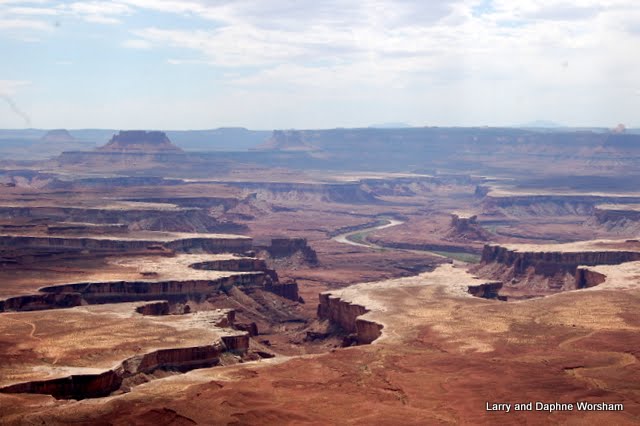
This is an amazing place. We're back to the multi-colored wedding cake layers we saw in Nine Mile Canyon, only this time we're on top, looking down, instead of standing in the canyon looking up.
The depth of the canyon and intricate loops in the Colorado River below are absolutely amazing. For those interested in geology, here's a great diagram of the layers and their ages. It's hard to absorb how very old the landscape is, and what forces were at work over the ten million years it took the river to sculpt it into the wonder we see now.
Dead Horse Point is state property adjoining the much larger National Park, Canyonlands, which has the same geology, but also contains the confluence of the Colorado and Green Rivers.
A tour of the Island in the Sky district of Canyonlands occupied our second full day. The road travels the edge of the canyon on a fairly level mesa, with multiple pull-outs and short trails to view points. There seemed to be a raven perched by the trail to meet us at every stop, and I began to feel we were being followed!
If you think this area resembles the Grand Canyon you are right! It's a bit more photogenic actually, due to being wider and not as deep. The movie industry has taken advantage of that feature and used this area as a stand-in for the Grand Canyon in several movies. The list of movies filmed in the greater Moab area is quite extensive, and a tour to some of the sites is great fun for movie buffs.
Both parks are much less crowded than Arches was, probably due to their greater distance from a major highway - tour buses don't want to swing this far afield.
With plenty of electricity available we've been able to run the air conditioning a bit and get a little respite from the heat. Yesterday clouds started to form, which made for some nice photographs, and by late afternoon we were getting thunder and a few sprinkles. It rained quite a bit overnight, filling up all the little potholes that support those cute little gnats, and fluffing up the cactus. The clouds continued to sit down in the canyon all day, looking like wet cotton, so it's a good thing we did our sightseeing previously as there's not much to see now.
The park name, Dead Horse Point has some history to it, but it's hard to track down any real facts. The naming of the area is always attributed to a "legend" with no dates and no human source. There seem to be three slightly different versions of the legend that are repeated everywhere. One version is, "The point was used as a corral for wild mustangs roaming the mesa. Cowboys rounded up these horses and herded them across the narrow neck of land and onto the point.
The neck of the plateau that forms the point, which is only 30 yards wide, was then fenced off with branches and brush, creating a natural corral surrounded by precipitous cliffs. Cowboys then chose the horses they wanted and left the other horses corralled on the waterless point where they died of thirst within view of the Colorado River, 2,000 feet below." A second version says the cowboys accidentally left the corral closed off. A third version says that the cowboys left the corral open, but for some inexplicable reason the horses just stayed in the corral.
Sorry, but I don't buy any of them. This is, I think, another example of sanitizing history. I do believe a herd of horses died out there on the point. But I don't believe it was accidental. During the late 1800's, when the event supposedly happened, the area was filling up with sheep and cattle ranchers. Everyone has heard about the range wars that were waged between the sheep ranchers and the cattlemen. What isn't usually discussed is the attitudes toward the herds of wild horses that ran the range at the time, competing for forage and tempting thoroughbred horses away from their corrals. Ranchers at the time put wild horses in the same category as a farmer does wild rabbits. They were a nuisance, and a drain on the system, so "get rid of 'em!" The wild horses were shot, poisoned, and worse. Some were rounded up and sold for a variety of purposes, but in those days, when a saddle cost $40, and a good horse $120 or more, a wild horse brought maybe $5. I think the herd in this "legend" was rounded up and killed on purpose. But that's too hard for people to hear, best to change history so it is easier to hear.
There's a display in the visitor's center that does the same thing, saying "horses originally developed in North America", uh sort of, but not exactly. It's true the Dawn Horse developed in the northern hemisphere, several million years ago, before the continents separated! There was no "North America", then. And the Dawn Horse is about the size of a dog, with toes, and looked more like a tapir than a horse.The Hagerman Horse also roamed the plains in this general area, several million years ago, but it is much closer to a zebra than today's horse. All facts that the display conveniently skips over, probably because emotionally it's easier to bond with a "horse" than a tapir. There were never any true horses (as we know them now) here until the Spaniards brought them.
There's a great book on the subject, much of which is available online. The Wild Horse of the West (Walker D. Wyman -1963) Devoid of the emotion that colors the topic currently, Wyman recounts the history of feral horses and the attitudes and reasoning behind the actions of ranchers and farmers. It's interesting to note that the same arguments going on now regarding the wild horse herds have been repeated many times in the past. (I'll get down off the soap box now!)
For a tour of the canyon check out the album.
Lots of gnats.
And a few mosquitoes thrown in just for variety.
Thank heavens we have a screen room tent! And there is a lesson learned. We ditched our old, heavy screen tent and bought a new, lighter weight one just before we left. 'Got it on sale for a super great price at a camping store. When we arrived here and decided it would be a good time to set it up, what with all the bugs and all, we laid the bag on the picnic table and unzipped it. Taking the posts out we suddenly were covered with a shower of beach sand. We are nowhere near a beach. It seems the tent had been used before, but not marked "returned". We just count ourselves lucky that there was no damage and no missing parts. Next time we should look as soon as we get home with something like that. . . but of course, we'll forget this lesson by then and do the same thing all over again!
We're camped in Dead Horse Point State Park, high up, with a bit of a view of the canyon edge.
The campground has no water, but there is electricity, and the sites are for the most part quite wide and well arranged. Ours is huge, with two tent pads and a picnic table that would seat 16 easily. All the table shelters have two-sided windbreaks with little cabinets built in. I think that's to protect things from the crows here that seem to be notorious for getting in to things.
We hit the visitor's center the afternoon we arrived so we'd have an overview of the area. At the visitor's center viewpoint one is treated to the shocking sight of two huge swimming pool blue ponds at the bottom of the canyon.
These are solar evaporation ponds that are part of a potash solution mining process, explained in detail on the placard near the viewpoint. The blue color is due to cobalt that is added to the solution to speed the evaporation process. Once the brine has evaporated the consolidated minerals are collected and trucked out.
The next day we hit all the overlooks and a few short trails. The heat again slowed us down a bit, but we still got some great photos!
This is an amazing place. We're back to the multi-colored wedding cake layers we saw in Nine Mile Canyon, only this time we're on top, looking down, instead of standing in the canyon looking up.
The depth of the canyon and intricate loops in the Colorado River below are absolutely amazing. For those interested in geology, here's a great diagram of the layers and their ages. It's hard to absorb how very old the landscape is, and what forces were at work over the ten million years it took the river to sculpt it into the wonder we see now.
Dead Horse Point is state property adjoining the much larger National Park, Canyonlands, which has the same geology, but also contains the confluence of the Colorado and Green Rivers.
A tour of the Island in the Sky district of Canyonlands occupied our second full day. The road travels the edge of the canyon on a fairly level mesa, with multiple pull-outs and short trails to view points. There seemed to be a raven perched by the trail to meet us at every stop, and I began to feel we were being followed!
If you think this area resembles the Grand Canyon you are right! It's a bit more photogenic actually, due to being wider and not as deep. The movie industry has taken advantage of that feature and used this area as a stand-in for the Grand Canyon in several movies. The list of movies filmed in the greater Moab area is quite extensive, and a tour to some of the sites is great fun for movie buffs.
Both parks are much less crowded than Arches was, probably due to their greater distance from a major highway - tour buses don't want to swing this far afield.
With plenty of electricity available we've been able to run the air conditioning a bit and get a little respite from the heat. Yesterday clouds started to form, which made for some nice photographs, and by late afternoon we were getting thunder and a few sprinkles. It rained quite a bit overnight, filling up all the little potholes that support those cute little gnats, and fluffing up the cactus. The clouds continued to sit down in the canyon all day, looking like wet cotton, so it's a good thing we did our sightseeing previously as there's not much to see now.
The park name, Dead Horse Point has some history to it, but it's hard to track down any real facts. The naming of the area is always attributed to a "legend" with no dates and no human source. There seem to be three slightly different versions of the legend that are repeated everywhere. One version is, "The point was used as a corral for wild mustangs roaming the mesa. Cowboys rounded up these horses and herded them across the narrow neck of land and onto the point.
The neck of the plateau that forms the point, which is only 30 yards wide, was then fenced off with branches and brush, creating a natural corral surrounded by precipitous cliffs. Cowboys then chose the horses they wanted and left the other horses corralled on the waterless point where they died of thirst within view of the Colorado River, 2,000 feet below." A second version says the cowboys accidentally left the corral closed off. A third version says that the cowboys left the corral open, but for some inexplicable reason the horses just stayed in the corral.
Sorry, but I don't buy any of them. This is, I think, another example of sanitizing history. I do believe a herd of horses died out there on the point. But I don't believe it was accidental. During the late 1800's, when the event supposedly happened, the area was filling up with sheep and cattle ranchers. Everyone has heard about the range wars that were waged between the sheep ranchers and the cattlemen. What isn't usually discussed is the attitudes toward the herds of wild horses that ran the range at the time, competing for forage and tempting thoroughbred horses away from their corrals. Ranchers at the time put wild horses in the same category as a farmer does wild rabbits. They were a nuisance, and a drain on the system, so "get rid of 'em!" The wild horses were shot, poisoned, and worse. Some were rounded up and sold for a variety of purposes, but in those days, when a saddle cost $40, and a good horse $120 or more, a wild horse brought maybe $5. I think the herd in this "legend" was rounded up and killed on purpose. But that's too hard for people to hear, best to change history so it is easier to hear.
There's a display in the visitor's center that does the same thing, saying "horses originally developed in North America", uh sort of, but not exactly. It's true the Dawn Horse developed in the northern hemisphere, several million years ago, before the continents separated! There was no "North America", then. And the Dawn Horse is about the size of a dog, with toes, and looked more like a tapir than a horse.The Hagerman Horse also roamed the plains in this general area, several million years ago, but it is much closer to a zebra than today's horse. All facts that the display conveniently skips over, probably because emotionally it's easier to bond with a "horse" than a tapir. There were never any true horses (as we know them now) here until the Spaniards brought them.
There's a great book on the subject, much of which is available online. The Wild Horse of the West (Walker D. Wyman -1963) Devoid of the emotion that colors the topic currently, Wyman recounts the history of feral horses and the attitudes and reasoning behind the actions of ranchers and farmers. It's interesting to note that the same arguments going on now regarding the wild horse herds have been repeated many times in the past. (I'll get down off the soap box now!)
For a tour of the canyon check out the album.
Tuesday, June 28, 2011
Berlin-Icthyosaur State Park, Part II
Berlin-Icthyosaur State Park is unique because it combines two outstanding features - the old mining town of Berlin (see the last post) and the world's largest concentration of fossilized icthyosaurs (literally "fish lizard).
Where as dolphins are fish-like mammals, and also come in various sizes and types, these were "fish-like" reptiles of which there were several different species. They needed air to breath, and came in several different sizes. Paleontologists have found them all around the world, but the specimens here are of the larger species (Shonisaurus popularis) and more complete than those found at many of the other sites.
It seems that during what is known as the Triassic there was something that killed a lot of little fish, or at least made them sick (something like the red algae we get now) and the several icthyosaurs ate the sick and dying fish, which killed the icthyosaurs, causing them to fall in an overlapping heap at the bottom of the ocean.
For some reason they were fairly quickly covered with sediment, thus preserving them in pretty much the same arrangement they were in when they died. These overlapping bones are tricky to interpret first, but once you see the arrangement of tails and fins it makes sense. The display in the shelter surrounds several overlapping animals, and important bones are marked so the presentation makes it easy to understand the mechanics of what happened.
Ocean? in Nevada?
Keep in mind, this event occurred about 200 million years ago, give or take a few months, so the environment has changed a bit since then.
At the time these critters were swimming around this area was ocean, it was farther south, probably in the tropics, and was situated along the western coast of what is now North America. This is all according to paleogeographers who study this sort of thing and interpret the changes in the rocks over time. An excellent resource for learning about the geology and paleohistory of this part of Nevada is Geology Underfoot in Central Nevada. The book has great chapters on both aspects of the park, including maps and photos.
The fossils were discovered in the 1930's, and Dr. Camp and is team spent about ten years studying them. Once the paleontologists were finished with their work the site was covered with a protective enclosure that is locked when there is no ranger present. The park offers tours twice a day (and a small fee is charged). The "tour" is helpful as just looking through the enclosure windows at the excavation isn't very informative. The ranger conducting the tour explains the various parts and pieces of the find, how they interpreted the events that brought about the deaths of these giant creatures, and answers any questions visitors might have. There also informative displays inside the enclosure.
As with any state park, you cannot pick up and keep any rocks or fossils that you find within the park boundary. However, if you are interested in collecting the rangers will be happy to direct you up Union canyon where just past the clearly marked park boundary you are free to explore and collect fossils and mineral samples.
| Note the long snout and large eyes of the Icthyosaur |
Where as dolphins are fish-like mammals, and also come in various sizes and types, these were "fish-like" reptiles of which there were several different species. They needed air to breath, and came in several different sizes. Paleontologists have found them all around the world, but the specimens here are of the larger species (Shonisaurus popularis) and more complete than those found at many of the other sites.
For some reason they were fairly quickly covered with sediment, thus preserving them in pretty much the same arrangement they were in when they died. These overlapping bones are tricky to interpret first, but once you see the arrangement of tails and fins it makes sense. The display in the shelter surrounds several overlapping animals, and important bones are marked so the presentation makes it easy to understand the mechanics of what happened.
| The thin bones at top left are a ribcage, round on lower right are vertebrae. |
Keep in mind, this event occurred about 200 million years ago, give or take a few months, so the environment has changed a bit since then.
At the time these critters were swimming around this area was ocean, it was farther south, probably in the tropics, and was situated along the western coast of what is now North America. This is all according to paleogeographers who study this sort of thing and interpret the changes in the rocks over time. An excellent resource for learning about the geology and paleohistory of this part of Nevada is Geology Underfoot in Central Nevada. The book has great chapters on both aspects of the park, including maps and photos.
| On the left the largest and on the right the smallest vertebrae found here. |
| Dr. Camp's illustration of an Icthyosaur skeleton. |
Tuesday, June 14, 2011
Olive Lee Memorial State Park, NM
This area was hit really hard by the extreme winter, and now the drought is taking its toll. The main trail, up Dog Canyon, is closed as it leads into the Lincoln National Forest, which is closed. The campsites here are snuggled up against the foothills - interestingly eroded, they are tall enough to block the sun until later in the day than one might expect. Because of the slope almost every site has a fantastic views of the Tularosa Valley, and at night the lights in the houses scattered throughout the valley twinkle like stars. The sites are spacious, and graveled paths wander among the yucca and mesquite.
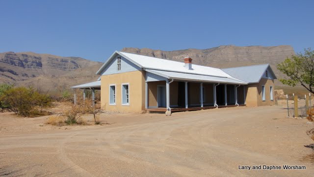
The visitors' center is small, and gives a brief overview of the area and the wildlife. The main feature of the park is the restored ranch house of Oliver Lee, a rather noteworthy figure in New Mexico's history. You can read about his encounter (as a murder suspect) with Sheriff Pat Garrett here and here in a True West Magazine story. They don't make a lot out of this particular bit of history in the park, but to us the story of Lee's involvement with Pat Garrett and a never-solved murder mystery was what made the ranch really interesting to us. Take time to read about the case - it's a fascinating piece of western history!
We were the only people who showed up for the three o'clock tour of the Lee Oliver Ranch (the 100 degrees outside may have had something to do with it) But Wendy, the park manager, gamely saddled up and gave us a private tour. It was nice to be able to talk about the history of the ranch, recent as well as past, in a little more detail than usually happens in a crowd.
| The wall was constructed for the movie. |
Monday 8:30 AM - up and out early - for us! and heading for the White Sands visitor center. The visitors' center is in a 1920's adobe building - beautiful, and cool! Their gift shop is stocked with a nice array of Native American arts, and the information center has a great selection of books for adults as well as a wide variety of books and activities for children.
We picked up a great slow-cooker cookbook: Southwest Slow Cooking by Tammy Biber and Theresa Howel - can't wait to try out some of the recipes! The displays in place are currently "place holders" as they are in the process of installing new state-of-the art displays. We'll have to catch those the next time we're passing through.
Check the album for a few more photos.
Labels:
Books,
History,
New Mexico
Monday, November 15, 2010
movin' on down Hwy. 395
| Coso rock art figure |
It's a nice little museum, and it is small, but they are well underway in doubling their space so we look forward to visiting again on our next trip through the area. We didn't have time for much touring, and there's a lot to look over. It's been over 30 years since we were here and saying it "has grown" would be a serious understatement.
We're on our way to visit a school chum from way back in middle school. We see her only seldom, so it's a real treat to be able to get together. We're staying at the Adelanto RV park, which is only a few miles from her house.
| Coso rock art figure |
Now, my memories of Adelanto, as a kid driving back and forth from our home in Long Beach to our place in Garlock, was that it was a dark intersection with a gas station and a place to buy blocks of ice for our cooler. There wasn't much else here. Again, saying it has grown doesn't quite capture it...... I wondered why the town was here in the first place, assuming mining as that was the purpose for most of these other little desert burgs.... but actually this was a different scenario.
From the city's website: Adelanto was founded in 1915 by E. H. Richardson, the inventor of what became the Hotpoint Electric Iron. He sold his patent and purchased land for $75,000. He had planned to develop one of the first master planned communities in Southern California. Richardson subdivided his land into one-acre plots, which he hoped to sell to veterans with respiratory ailments suffered during World War I. He also hoped to build a respiratory hospital. While Richardson never fully realized his dream, it was his planning that laid the foundation for what is currently the City of Adelanto.
Acre after acre of deciduous fruit trees once grew in the city. Famous throughout the state for fresh fruit and cider, the orchards thrived until the depression, when they were replaced by poultry ranches. As the wartime emergency developed early in 1941, the Victorville Army Air Field was established land within the Adelanto sphere of influence. In September 1950, It was named George Air Force Base in honor of the late Brigadier General Harold H. George. Adelanto continued as a "community services district" until 1970, when the city incorporated, and Adelanto became San Bernardino County's smallest city. The city became a charter city in November 1992.
Of interest in the area include nearby Lake Mirage, where several movies have been filmed, including one of the well known scenes in the Lethal Weapon episode where the good guys met the bad guys on a dry lake.
One of the most surprising features of the Adelanto area is the Thien Vien Chan Nguyen Buddhist Meditation Center.The 24-foot-tall, 60-ton white marble statue of Quan yin, an "Enlightened One," is quite startling as it's only a short distance off the highway. It is a part of a Buddhist meditation center in the Mojave Desert. The planned $15 million temple is the vision of a senior citizen monk, Thich Dang "Tom" Phap,[67] who lives next to the statue in a trailer. The Quan yin statue attracts many Buddhist visitors, who believe that it possesses healing powers and radiates a white light. The center's walkway features statues of 18 other Enlightened Ones. [RoadsideAmerica.com Team, 12/01/2008] Here's a slide show from the Press-Enterprise
Though most don't realize it, the Mojave Desert is where the business end of Southern California happens. The aqueduct, that brings the water, the solar plant at Cramer Junction, and other electric resources like the static inverter plant, that provide the electricity, correctional facilities, military bases, and other essential services too "uncomfortable" to have based in more densely occupied areas are routinely relegated to the desert where "nobody" lives. These mundane and sometimes threatening services seem a stark contrast to the beauty of a Joshua tree silhouetted against the sunset, or the sparkle of a few distant lights in the distance in the inky night. The people who do live here, though relatively few in number, are hardy, self reliant individuals, though there is a great deal of economic suffering here as in many other smaller communities. The few jobs there were are rapidly drying up. Sad to see.
Labels:
Books,
California,
Museums
Thursday, July 29, 2010
The good, the bad and the indifferent
If you've followed this blog for very long you know we've stayed in some really scenic places, some that have full services and are carefully maintained, others that are picturesque but very rustic, and then there's this one.
Last night we stopped in Fruitland, Idaho, to catch up on laundry and shop for groceries. The place we'd intended to stay turned out to be right on the railroad tracks. Been there, done that, didn't like it, so we kept looking. There are very few RV parks or campgrounds in this area, so we opted for the "bare bones" approach.
The Exit-3 RV Park (ing lot), behind the Fruitland Produce Barn, served our purposes, and you can't beat $15 for the night, with water and power. The "park" is fully graveled, full of maple trees, so there's lots of shade, and right on the edge of vegetable fields that supply the produce market in front. Even though the park is near the freeway it was not particularly noisy, as the freeway is elevated and noise seems to travel up. It was hot, so we left the bedroom door open a bit, and drifted off to sleep to the aroma of mint and lemon balm. There are worse things!
Today we are moving west, toward John Day, Oregon. As we leave the Great Basin area I have to say, it's been heartwarming to see all the small (by industry standards) farms and ranches that are well maintained and producing crops of corn, wheat, alfalfa, and salad crops. I've seen more ranchers than I can count on horseback, or on the ground mending fence with their horse waiting patiently to the side, fat, sleek (and presumably happy) cattle and horses, teenagers running large farm machinery, and small rural communities that still pull together no matter what the economy is doing. THIS is America, and yes, this way of life still exists. I do need to set the record straight on one thing - in the Great Basin they aren't "cowboys", they are "buckaroos". If you'd like to see more of what this life is like, check out this link Kurt Markus then click on "western archive". Kurt Markus has a feel for the lifestyle that most authors and photographers just can't equal. Click on the link for his book "Buckaroos", to see what that offers. He captures this area with a sensitivity unmatched by other photographers.
Last night we stopped in Fruitland, Idaho, to catch up on laundry and shop for groceries. The place we'd intended to stay turned out to be right on the railroad tracks. Been there, done that, didn't like it, so we kept looking. There are very few RV parks or campgrounds in this area, so we opted for the "bare bones" approach.
The Exit-3 RV Park (ing lot), behind the Fruitland Produce Barn, served our purposes, and you can't beat $15 for the night, with water and power. The "park" is fully graveled, full of maple trees, so there's lots of shade, and right on the edge of vegetable fields that supply the produce market in front. Even though the park is near the freeway it was not particularly noisy, as the freeway is elevated and noise seems to travel up. It was hot, so we left the bedroom door open a bit, and drifted off to sleep to the aroma of mint and lemon balm. There are worse things!
Today we are moving west, toward John Day, Oregon. As we leave the Great Basin area I have to say, it's been heartwarming to see all the small (by industry standards) farms and ranches that are well maintained and producing crops of corn, wheat, alfalfa, and salad crops. I've seen more ranchers than I can count on horseback, or on the ground mending fence with their horse waiting patiently to the side, fat, sleek (and presumably happy) cattle and horses, teenagers running large farm machinery, and small rural communities that still pull together no matter what the economy is doing. THIS is America, and yes, this way of life still exists. I do need to set the record straight on one thing - in the Great Basin they aren't "cowboys", they are "buckaroos". If you'd like to see more of what this life is like, check out this link Kurt Markus then click on "western archive". Kurt Markus has a feel for the lifestyle that most authors and photographers just can't equal. Click on the link for his book "Buckaroos", to see what that offers. He captures this area with a sensitivity unmatched by other photographers.
Friday, July 23, 2010
De Lamar and Silver City, Idaho
We liked the Snake River RV campground so well we decided to stay another night. We're so close to Silver City, a ghost town we'd visited in the early '70's, that we thought we go back and see how it's weathered the years.
We took the route east from highway 95 turning east on Cow Creek Road we passed a couple of old but still working ranches and a lot of very well fed cattle. A few miles in we came to the site of De Lamar. This silver mining town was build by a retired ship's captain, and he named it after himself. He obtained several mining claims, built a school, hotel, stores and other buildings. The town pretty much folded up many years ago, though with the rise in metals prices there is an open pit operation opened up nearby.
As far as the town, there are only the tumbled down remnants of the mill and a few cabins in various stages of decay scattered along both sides of Jordan Creek. The two cabins we peeked in to are luxuriously furnished with large pack rat nests, made of the stuffing from mattresses left behind by the last human residents and large sticks the rats have collected. In front of one cabin remnants of a lady's garden, a lilac bush and small patch of rhubarb, are nearly overrun by wild roses and sagebrush.
They say all that glitters is not gold, and that's definitely true here. A short distance east of De Lamar the road sparkles like diamonds in the morning sun. The gem-like sparkles are actually only bits of eroded mica and quartz. The effect is a stark contrast to the other travelers we met on the road . . . we arrived at the peak of the annual Mormon cricket migration! The road was covered for miles with thousands of red and black crickets, all heading west! It's a little creepy to see so many insects move with such organized purpose!
Silver City is just east of the summit. The buildings are all privately owned, some serving as full-time residences, some as weekend cabins. Many are in various stages of restoration. The hotel and a gift shop are the only businesses in town, and they are open primarily on the weekend. There's a lot of snow in the winter, up there at over 6,000 ft., from 4-6 feet, so their season is May-October. Most residents leave town for warmer climes in the winter, leaving a solitary watchman in charge. The town hasn't had electricity for several years, so most of the buildings have solar panels and propane as their power sources. Understandably, they are very careful in their use of power.
We stopped in the hotel to chat with the owner and have a beer at the antique bar, and it was dark! 'Makes sense considering the limited power supply, and I'm sure the old timer's didn't have "lights on" during the day either. Whether one used candles or lamps, why would you use up fuel in the middle of the day? As we sipped our beer we wandered around the edges of the dining room/bar enjoying the photos and antiques in display cases. We also invested in a book, "Ghost Towns of Idaho - The Search of El Dorado", by Bruce Raisch. We won't have time this trip to explore very many of the towns he writes about but the book will be a great resource for planning future trips, and good reading. The author's website has info on ghost towns in other states too.
We drove around town, took a lot of photos as the old buildings are just too picturesque to resist, and then had lunch in the campground. So many of the old mining towns are disappearing due to vandalism, It was nice to see that the town's been so well taken care of.
Here's the slide show of the trip. Click on it to go to the larger version and get the captions.
We took the route east from highway 95 turning east on Cow Creek Road we passed a couple of old but still working ranches and a lot of very well fed cattle. A few miles in we came to the site of De Lamar. This silver mining town was build by a retired ship's captain, and he named it after himself. He obtained several mining claims, built a school, hotel, stores and other buildings. The town pretty much folded up many years ago, though with the rise in metals prices there is an open pit operation opened up nearby. As far as the town, there are only the tumbled down remnants of the mill and a few cabins in various stages of decay scattered along both sides of Jordan Creek. The two cabins we peeked in to are luxuriously furnished with large pack rat nests, made of the stuffing from mattresses left behind by the last human residents and large sticks the rats have collected. In front of one cabin remnants of a lady's garden, a lilac bush and small patch of rhubarb, are nearly overrun by wild roses and sagebrush.
They say all that glitters is not gold, and that's definitely true here. A short distance east of De Lamar the road sparkles like diamonds in the morning sun. The gem-like sparkles are actually only bits of eroded mica and quartz. The effect is a stark contrast to the other travelers we met on the road . . . we arrived at the peak of the annual Mormon cricket migration! The road was covered for miles with thousands of red and black crickets, all heading west! It's a little creepy to see so many insects move with such organized purpose!
Silver City is just east of the summit. The buildings are all privately owned, some serving as full-time residences, some as weekend cabins. Many are in various stages of restoration. The hotel and a gift shop are the only businesses in town, and they are open primarily on the weekend. There's a lot of snow in the winter, up there at over 6,000 ft., from 4-6 feet, so their season is May-October. Most residents leave town for warmer climes in the winter, leaving a solitary watchman in charge. The town hasn't had electricity for several years, so most of the buildings have solar panels and propane as their power sources. Understandably, they are very careful in their use of power.
We stopped in the hotel to chat with the owner and have a beer at the antique bar, and it was dark! 'Makes sense considering the limited power supply, and I'm sure the old timer's didn't have "lights on" during the day either. Whether one used candles or lamps, why would you use up fuel in the middle of the day? As we sipped our beer we wandered around the edges of the dining room/bar enjoying the photos and antiques in display cases. We also invested in a book, "Ghost Towns of Idaho - The Search of El Dorado", by Bruce Raisch. We won't have time this trip to explore very many of the towns he writes about but the book will be a great resource for planning future trips, and good reading. The author's website has info on ghost towns in other states too. We drove around town, took a lot of photos as the old buildings are just too picturesque to resist, and then had lunch in the campground. So many of the old mining towns are disappearing due to vandalism, It was nice to see that the town's been so well taken care of.
Here's the slide show of the trip. Click on it to go to the larger version and get the captions.
Labels:
Books,
Ghost towns,
Idaho,
Mining camps
Subscribe to:
Posts (Atom)