Showing posts with label petroglyphs. Show all posts

Sunday, February 18, 2024

Painted Rock Petroglyph Site and a couple of one night stands

 Painted Rock Petroglyph Site and Campground is part of the Bureau of Land Management system. As a BLM campground is had been free in the past, but as with most of their campgrounds they had started charging a nominal fee several years ago. Now they've gone to a new system, which requires the camping registration and fee be handled online. (You can't even go camping these days without needing the Internet for something!) 

We had registered and paid for our site online the day before our arrival, but just our luck, when we arrived it was occupied! The folks who had decided to settle there had no idea they had to pay to stay there! (note to campers..... read the notices as you enter a campground). They graciously left the site and sought one elsewhere. 

We settled in for the evening and enjoyed the uninterrupted view of the desert. Wide open space and no traffic are rare these days, even in the desert. 

Right after breakfast the next day we walked over to the relatively small rocky outcrop that was situated right in the middle of camp! I'm accustomed to having to trek up fairly challenging trails in some cases to see petroglyphs. These are right in our front yard!  

If you are a fan of petroglyphs, all you can say is WOW! In an article about this site Wikipedia states there are approximately 800 figures in this collection. Even if you aren't, the sheer number and variety of glyphs carved here, over several hundred years, is amazing to think about. Some of the older ones are quite faded due to the continued erosion of the rock, and the ongoing patina forming on the stone. (Patina is the dark brown/black layer that forms on stone that is exposed to the elements for long periods of time. Petroglyphs like these are formed by pecking through that layer, usually with a stone tool. In the photo below the glyphs are layered, with the newer ones on top and much more clearly defined than the older, dim carvings underneath

The importance of this area to several cultures can only be understood if you look at a map and understand that the Gila river, which supports wildlife (aka food for native people), the map on the website linked to above shows the early explorer and pioneer trails, and now highways, cuts right through here. So the proliferation of glyphs may be attributed to the number of travelers passing by, or ????  Interpreting petroglyphs is very subjective, and it's fun to imagine why they are here, but no one can be certain they have the correct interpretation. 

In the afternoon I took the dogs for an off-leash walk out to the riverbed, dry at the time but easy navigating. They enjoyed the opportunity to explore at their leisure with no leashes required as we don't get an opportunity for that kind of exploration very often. 

The following morning we departed for a one night stay in Picacho State Park. This is a regular stop for us when traveling to and from AZ or CA.  The photo below is taken from our site looking toward I-10, a very busy highway, with Newman peak in the distance. The highway is far away, and though we can see the steady stream of traffic we never hear it. At night the lights shine so brightly it looks like a diamond bracelet stretching across the valley.


The park has beautiful scenery, an interesting history, and if you visit a bit later in the year, lots of wildflowers. We were two weeks later last year, so there were more flowers in bloom. Check out that post for details.

For the following day, a short drive, a quick trip to the grocery store, and then one night in Kartchner Caverns State Park. This is another favorite as well as convenient stop on the way home. Good trails for walking, the visitor center is really well done, and the cave tours are too. We spent quite a bit of time here last year. That adventure is here.

Next, a long drive ahead of us, to Rockhound State Park, New Mexico. 

More photos in the album!

Tuesday, February 21, 2023

White Tank Mountain Petroglyphs

 We didn't realize it when we made the reservations for the park, but after we arrived we learned there are several petroglyphs located here. Collecting photos of the rock art is one of our hobbies, so before we left we made time to hike the most target rich trails. 

The glyphs here are the type that are often called entoptic. These are seemingly random "doodles", unrelated images that are inspired by visions, or meditations, of the person who was responsible for the petroglyph. They are thought to be related in many cases to the coming of age tradition of a "vision quest". In many tribes an individual set out alone for a period of time to survive on their own and meditate on their place in the tribe and family and their future. Each culture approached this differently, but often they spent much of their time in areas where water was available, both because this was a necessity for survival, and because the presence of water evoked a connection to higher powers. 

Here is a small sampling of what the area has to offer. We didn't thoroughly explore the area due to time restraints and crowded trail. Park rules also require staying behind the railings, so it's difficult to photograph some of the smaller glyphs. I suggest clicking on each photo and opening it up individually to see the detail. Or, open the album link (which has more photos) at the bottom of the page and view the photos in a larger format that way. 


Monday, August 1, 2011

Newspaper Rock, UT

After three nights at Dead Horse Point we were beginning to feel like the old timers in the neighborhood. Everyone else stopped for only one night, did a dash through the park, then left the next morning. It’s too bad people don’t have a little more time to really sit and enjoy the area and the trails. This is a good base camp for exploring Canyonlands and Arches, so one could easily spend a week here.

Our next planned stop, Newspaper Rock, is a bit south of Moab.

A nice stop along the way is Wilson Arch. 26 miles south of Moab on Hwy. 191, the arch will be on your left. It’s a really nice, photogenic formation right beside the road, and there’s a pull-off so it’s easy to get a good shot. You can see by comparison to the two people standing in the arch how large it is.

Newspaper rock is only a few miles further on, 12 miles west on hwy.211.

Newspaper Rock is a huge collection of glyphs that have accumulated over many generations, and represents several different cultures. There are informational placards at the site, and restrooms in the parking area. Check out the overhanging boulder as you approach the parking area. It has glyphs on it too.

In the short time we were there a steady stream of visitors to the rock took pictures and some spent time meditating on the meanings behind the drawings. The intent of some of the drawings seems fairly evident, others, we will never know. Perhaps that’s the draw of rock art, it’s a total mystery in most cases!

The campground at Newspaper Rock is closed due to fears of flooding, so we back-tracked just a bit to a road that cuts southeast, up over the mountain to Dalton Springs.

There’s a nice viewpoint at the top – wow! What a view! I’m not sure how far away “forever” is but I’m sure you can see it from here.
After the recent rains the air is clear and all the gorgeous colors are bright. The view point has several informational signs and a row of viewing tubes. We’d never seen these before – a short piece of pipe to look through is attached perpendicularly to a post, and aimed at a particular point on the horizon. Each was originally fitted with a little sign to tell you which mountain you are looking at, but most of them have been removed.

Dalton Springs campground is a rustic hunting camp tucked up in an oak forest. Amenities are simple and include vault toilets and a couple of water spigots, with nice big spaces set far apart so everyone has privacy. With all the trees and another impending thunderstorm we felt like we were back in Oregon. While we stayed inside, safe from the rain and lightning, several deer wandered through camp, clearly aware that hunting season hadn't opened up yet.

There wasn’t a lot of rain in this storm, but quite a bit of thunder. There’s nothing like being on the top of a mountain (roughly 8,000 ft.) during a thunderstorm to get the full effect!

Saturday, July 23, 2011

Green River, UT

Our neighboring camper at Nine Mile Ranch invited us to share his campfire one evening and as we got acquainted we discovered we had a lot of interests in common. An experienced desert rat himself, he suggested several sites he thought we'd enjoy visiting. One, Sego Canyon, was easy to fit into the schedule as it's only 25 miles east of Green River, where we'd planned to spend the next couple of days.

We arrived at Green River State Park just about lunch time and were quite surprised to find it completely empty, except for a handful of rafters milling around the put-in area. The campground is really nice, and so green it seems merely an extension of the golf course that is attached. There are no hook-ups, but water is available and as long as there are sunny days our solar panel keeps cranking out the the electrons so we're in good shape. The restrooms here are really nice too, which I'm sure the tent campers appreciate.

Evening brought a classic thunderstorm. The air went from totally still to blustery and wet, with some amazing lightening. The storm produced quite a bit of water, as we saw the next day when we were out touring. When they warn about flash floods in this country, pay attention!

Thompson Springs Motel
We left right after breakfast for Sego Canyon. It's east on Interstate 70,  about 25 miles to the Thompson Springs exit. Thompson Springs was an active railroad town at one time but now, like many railroad towns, it's now pretty much abandoned. The brick building that was a cafe still has the counter and other furniture inside, and there an old metal chair outside the hotel, looking as if someone just got up and went inside.

To get to the rock art, go north past the old Thompson Springs school. It's about 3 miles to the rock art site. There's a restroom there, and a picnic table with no shade.

This site is fantastic! Plenty of interpretive signs if you aren't knowledgeable about the subject, and easy to navigate trails for good viewing angles. Everything is near the road so hiking isn't a requirement.

Panel at the old corral
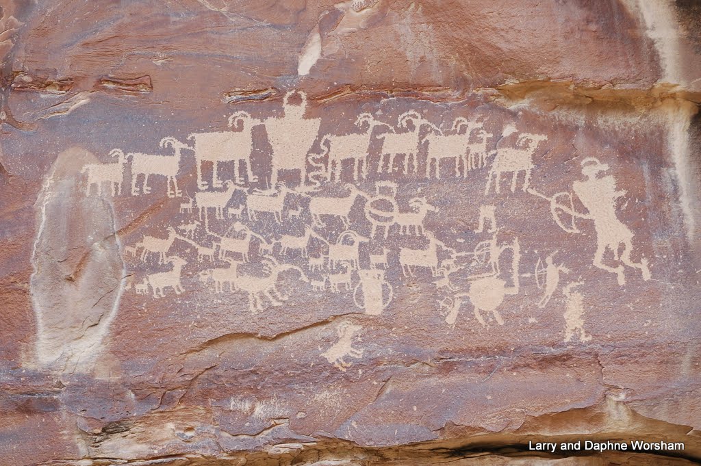
These examples of Ute, Fremont, and Barrier style rock art are amazing, some of them dating back thousands of years. The site itself is beautiful. The drawings cover towering cliffs that have fascinating shapes and mineral stains that look almost like paintings. When I noticed the area is an alcove it reminded me of research done by Steven J. Waller on the acoustics of rock art sites. He has done considerable research on the acoustic effects of rock art sites, and theorizes that some of the sites may have been chosen specifically because of the echos produced there.

Panel at the picnic areaa

Unfortunately there's been a good deal of vandalism here. I'm glad we were able to see these areas before there's even more destruction.

If you aren't into rock art, how about a couple of ghost towns?

Oven at the old homestead
Drive on up past the rock art site taking the left fork in the road into Thompson Canyon, where you'll find the remains of two dug-outs and a brick oven with a roof over it.

This was a cozy little enclave in early days, known as the Stortini farm, and they used the oven to bake bread, storing food and other items in the stone dugout according to reminiscences of their granddaughter.

The Thompson Canyon road doesn't go much past the farm, so turn  around and go back to the fork you passed on the way up, it will take you to the town of Sego. You'll pass the cemetery soon after the fork. We found mention of the Stortini family in the graveyard. There may have been more than one grave belonging to the family as many aren't marked. Someone has tended the graves recently, forming crosses of stone and leaving artificial flowers. Actually, only a few graves are identified, and several look like the classing "cowboy grave", just mounds of dirt and rocks.

All that's left of Sego
Travel a bit further on past the cemetery to the ruins of the town of Sego. There's not much left now, just a couple of stone buildings and the collapsed wooden boarding house. There's a nice big cottonwood to picnic under, and plenty of chunky black coal drifting down the hillsides to demonstrate why the town was here in the first place. Coal mining provided jobs for a good many people in the canyons from 1911 to the early 1940's. A special rail line was built up to the mine to accommodate shipping of the coal, but when water and other expenses started to become an issue the mine was shut down. It opened up again a couple of times but due to labor costs and other issues the owners really struggled to make a profit.

When the railroad line to the mine was abandoned in 1950, the owners of the mine owners constructed a truck ramp in Thompson to load coal directly into the railroad cars. The ramp and much of the grade still exists, as well as a couple of the trestles, but they trestles are in a dangerous condition and cannot be crossed.

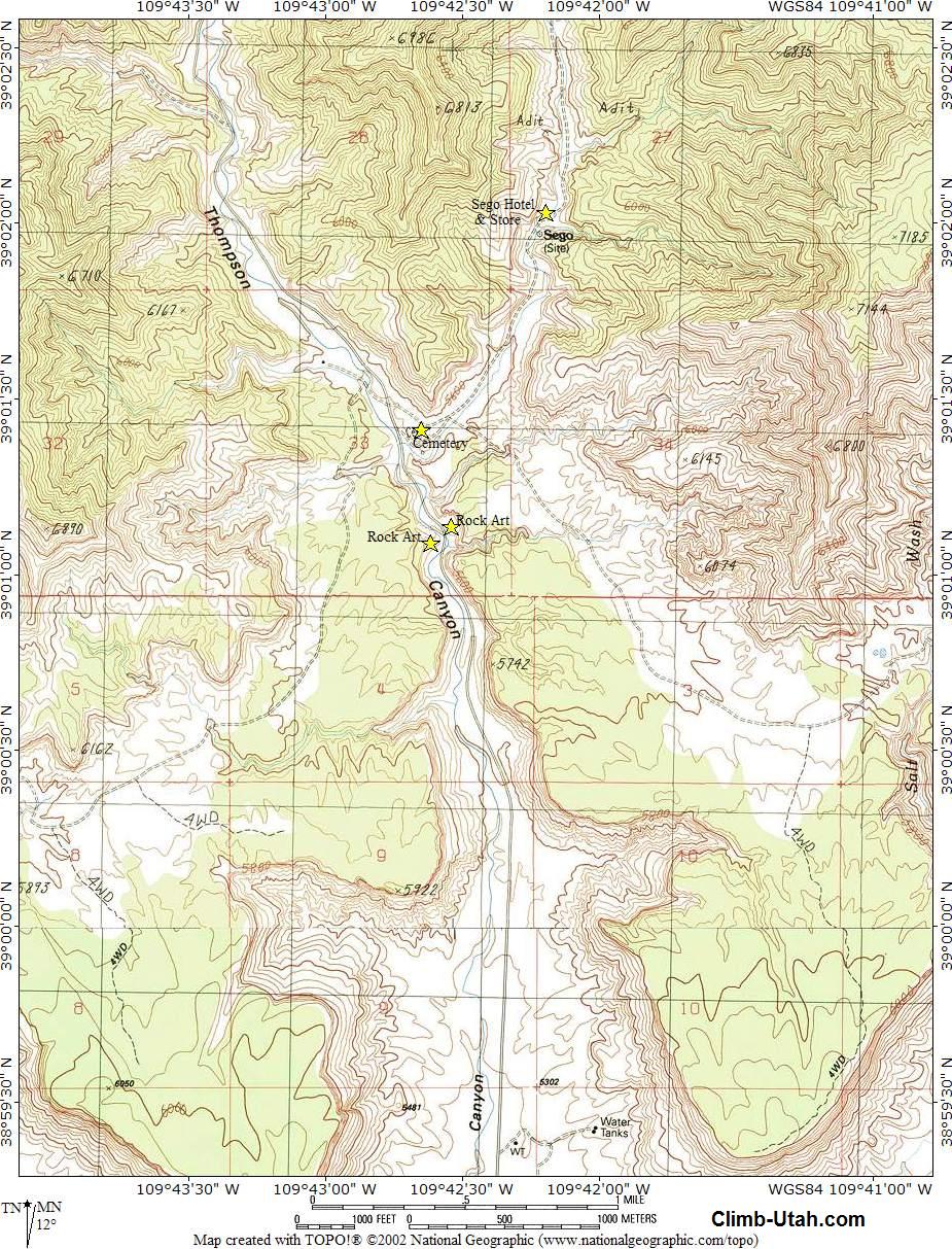
There's more about the ghost town of Sego in Wikipedia, and Kathy Weiser's article here. Link to a topo map of the area here.

What a day! Hard to fit in the blogging when there's so much adventuring to do! Before we left Green River we had one more stop to make - Ray's Tavern, also recommended by our camper friend.
'Best burger and brew we've had in a long time! If you're in Green River, stop in!

Check the album for more photos.

Thursday, July 21, 2011

Nine Mile Canyon, UT - Part II

Granary high up on a cliff
Nine Mile Canyon must have been a comfortable place to live a thousand or more years ago. There is evidence of good hunting, grain storage, and multiple tribal cultures over the centuries.

So called “Fremont Culture” that once populated this area actually includes several different tribes and cultures spanning hundreds of years. There are several places where evidence of their occupation can be seen, such as granaries and stone foundations for pit houses, and other primitive structures.

If you care to hike the hillsides, guides available on the web (see below) will direct you to the stone rings that identify the location of pit houses and watch towers built by the first inhabitants. Granaries where provisions were stored are still visible, and some were found with grain still stored inside.  It's fascinating to view these ruins and wonder at how they were built in the first place. The big draw of the canyon for visitors today, however, is the petroglyphs.

Most of the petroglyphs were created approximately 1,000 years ago, and considering these are pecked into or painted on relatively soft sandstone it is a wonder they are as well preserved as they are.

Many still appear crisp and clear, others have suffered the ravages of vandalism and weather. Still, there is much to admire, whether for the art, or for the challenge of attempting to decipher the message intended in the drawings. 

Some of the panels and areas with a lot of rock art are named for the pioneers that lived in the area. Daddy Canyon (presumably named for ranch owner Katherine Nutter's nickname for her husband), and Rasmussen's Cave, for instance.

These two sites are actually right next to each other, and just across the road is a gas processing plant, as well as the ruins of a small stone building, partially buried in the sagebrush.
Stone house ruins

Sixty three of the rock art panels are listed in the National Registry of Historic Places, and many of the panels and motifs have been replicated in museums as being among the finest examples of specific styles and eras in American rock art.

Visit our album to see a few of the photos we've selected as being the most outstanding examples. We had to be selective, considering the number of shots we took, and it was hard making those decisions!

We used the Climb Utah guide and the Utah Outdoors guide. There's also good information available from the BLM on this site.

These self-guided tour publications help identify these sites, but you'll have to do a lot of searching too as landmarks are hard to come by and everyone's mileage varies a bit. The guides will provide you with invaluable information about each specific site, far more than we can include here. You’ll need to drive slowly, get out and walk, do a lot of looking at the cliffs with binoculars, and always turn around and look behind you, as often glyphs are pecked in all sides of a cliff or boulder. Shifting light can also obscure or display carvings you didn't notice before. I really think you could visit this canyon many times and see something different on each visit.


Tuesday, July 19, 2011

Nine Mile Canyon, UT - Part I

Nine Mile Canyon had been on my "bucket list" for quite a while, as it is an area known for some great rock art, and since it was "on the way" after leaving Park City we planned a few days in the area.

The canyon is truly a study in contrasts. Here, you can experience the very old and the very new, the quiet of narrow canyons and small gurgling streams, and the hustle and bustle of the natural gas industry and ranching.

Formed by layers of lake mud compressed over the eons, the sides of Nine Mile Canyon are built of layer upon layer of mudstone, shale and sandstone. Richly colored and sculpted by erosion, they are fascinating scenery and would be the perfect backdrop for a western movie. The towering sides rise to over 7,000 feet, more than 1,200 feet above the valley floor. The dramatic and awe inspiring  view alone is worth a trip to the canyon.

Over a span of about 8,000 years many successive cultures have called this area home. The earlier are grouped together under the term “Fremont Culture”, later the Utes roamed the hillsides. Following closely after them were pioneer settlers and a few world-famous cowboys and “bad guys” like Butch Cassidy and the “Wild Bunch”, as well as the U.S. 9th Calvary (Buffalo Soldiers). Truly a microcosm of western history, there's a lot to explore in this narrow canyon.

Early ranchers established grazing areas for their cattle and judging by the ruins we can still see today they built some pretty impressive buildings and holding pens. Many of the homesteads were built up against the rocky cliffs, for a bit of wind protection perhaps. Most of those  old ranches now stand forlorn and forgotten, roofs caved in and doors hanging ajar, but nonetheless protected by law from destruction, as is the rest of the canyon.

The canyon doesn't seem lonely, however, as the various pipeline operations and working ranches generate a considerable amount of traffic, in addition to the tourists moseying along the road checking out the petroglyphs and scenery just as we were. There are still a few working ranches here, and cattle seem to think they own the road, but the picturesque abandoned ranches far outnumber the occupied ones.

You might say Nine Mile canyon is remote, if you consider its lack of services, and the approximately 22 miles one must drive to find a store of any kind.

There is no cell service here, no mail boxes, no newspaper delivery, but there are deer and a rushing creek, and those fantastic sandstone spires contrasting with billowy clouds, petroglyphs and Fremont culture ruins and pioneer cabins provide enough entertainment for us.

Nine Mile Canyon is actually about 40 miles long, the name coming from early days when John Wesley Powell was exploring the area. There are several side canyons worth exploring if you have the time and inclination, but plan for several days here in order to do so. The tour guides say you can “do it in a day”, but it took us two, and we didn’t get to everything we had intended to see, much less any of the inviting gravel roads leading off into the narrow side canyons.

Natural gas plant on the left
Several petroleum companies have been operating in the canyon for many years, and there have been some emotionally charged conflicts between them and the conservationists who seek to protect the petroglyphs, Indian ruins and historic pioneer buildings from the ravages of the dust and fumes produced by vehicular traffic. Dust, which damages the petroglyphs, is the major complaint.  Some compromises have been reached.  There are paved sections in some areas, and in others magnesium chloride is sprayed on the road as a dust inhibitor, though experience and research is now showing there are drawbacks to this treatment too.

Some sections of the road have been routed further away from petroglyph panels to give them a little more protection from dust and fumes.  As usual with compromises, probably neither side is totally happy but all the final ends are accomplished. . . jobs, energy, preservation, and access for the public.  We are just grateful for the opportunity to visit the area and appreciate both the need for energy and the need to preserve historic areas. We also noted that the roads used by the petroleum companies tend to be better maintained than in other areas, another bonus for travelers.

This canyon is famous largely for the petroglyphs, the number as well as the style. We'll share more about those in the next blog post. The younger, pioneer history is important too, and definitely worth experiencing.

The ghost town of Harper, as well as Nutter Ranch, are both locations with a number of standing buildings. Harper once had a stage coach stop, inn, school and postoffice. Now, mere shells of those buildings remain.

Much of the property along the canyon is privately owned, so watch for signs and respect them. It’s easy to get good photographs without trespassing (or annoying the cows).

Gate Canyon intersects Nine Mile Canyon at about the halfway point. Named for a stone arch that went over the road back in stagecoach days, the arch was demolished because of fears it would fall and crush the stagecoach or other travelers who passed beneath it.

Outlaw Point
Gate Canyon is also the location of “outlaw point”-
"Outlaw Point" is the sharp bend in the road where a group of outlaws intended to ambush the soldiers escorting the army payroll and Indian annuities.  The plan was to kill all 20 soldiers in the escort and leave no living witness.  While some members of the "Wild Bunch" allegedly participated in the scheme, Butch Cassidy, Sundance Kid and Elza Lay did not.  They knew the army would hunt them relentlessly for such a bloodbath.  The army was told of the plan by an informant and the guard was double to 40 soldiers.  The Outlaws hiding on the ledges hastily called off the ambush as the heavy escort rode through.  There is speculation that Butch Cassidy was the informant when he realized that he would be blamed for the crime, whether he participated or not.

If you follow Gate Canyon to the summit you’ll be rewarded with a view back, north, to the snow capped Uinta Mountains. As you climb the canyon you'll be following the face of the Badland Cliffs, skirting the edge of the Uintah and Ouray Reservation.  The road eventurally joins Hwy. 40, near Myton, but we turned around at the summit and went back down to Nine Mile Canyon.

Along Gate Canyon road you’ll see signs of the road build by the 9th Calvary. The names of many of the soldiers are painted in black axle grease at the base of a cliff near where the road crosses a creek. They also installed a telegraph line in the canyon and many of the slim metal poles are still in place.The cabins that served as the telegraph office, and their bunk house, are still standing at Nutter's Ranch, down in the main canyon.
Telegraph pole

If you plan to visit Nine Mile Canyon do your research ahead of time as you’ll have no Internet service once you enter the canyon proper. Try to obtain at least two guides. We used three, one from Utah Outdoors and Climb Utah  as well as one the folks at Nine Mile Ranch handed us, produced by the Carbon County Travel Bureau and others. There's also good information available from the BLM on this site.  Each offers a bit of different information so you need to cross-reference. Mileages and gps readings vary and the road is constantly being altered, so take all the directions with a grain of salt.

The only camping in the canyon is at Nine Mile Ranch. The ranch has a few small cabins if you want to go that route. Everything here is rustic, but comfortable.

There are two camping areas and we chose the lower one, Cottonwood Hollow, as it accommodated the length of our rig a bit more comfortably. You can see a bit of white between the trees in this photo - that's us!
Nestled up to the creek we had a nice view, and privacy from the other sites. We stayed three nights, which gave us time to really soak up and enjoy the area. We celebrated our visit to the canyon the first night with a great stew and a new Dutch oven biscuit recipe, named in honor of the canyon. Check it out at The Cookhouse.

Our excursions kept us away from camp 4-5 hours each day, and though we did have to cover some of the same ground on the second day to get to the area we had designated as "day 2" it proved to be a good plan. There's no way we could have covered it all in only one day. The last day we were barely back in camp when a big (but brief) thunderstorm hit.  Trail weary but happy to have seen all that we did over the last two days, we relaxed over a nice steak dinner and prepared to break camp.

There are more pictures from the canyon here. . . . next post, the petroglyphs!

Thursday, July 7, 2011

Lagomarsino Petroglyph Site, Nevada

Our annual 4th of July BBQ and reunion with friends from "the old days" brings us to Gardnerville, Nevada, every year. As usual we had a terrific time - and ate way too much! It is always wonderful to catch up with old friends, and this year almost everyone's children, and in some cases their grand children, were able to attend so it was a particularly historic year.

There was also an additional treat this year. Our hosts, knowing of our interest in rock art, asked if we were interested in seeing the largest petroglyph site in the state. It took about 10 seconds of serious deliberation to answer that question!

Plans for the trip were interrupted by a thunderstorm - not only NOT a good time to be up on a mountain top, but also not a good time to go exploring on primitive roads. A sunny day followed, so cameras and lunch loaded up, my guide, Grant, and I took off for Logomarsino Canyon. (Steve unfortunately had been committed to another activity that day.)

Grant had warned us the road was narrow and rough, and it wasn't an exaggeration. Heading out to the suburbs of Virginia City we followed an organized pile of rocks that passes fairly well for a road, wandered through the canyons, and admired the scenery along the way.

One striking feature of the landscape is the number of rock walls - remnants of the early sheep ranching era. Miles and miles of wall run up and over the rolling foothills. Some of the stones used to build these walls are amazingly large, and one has to wonder at the technique and pure brute strength needed to construct them.

There are no sheep to speak of now, but there are herds of wild horses everywhere. Presumably they've either learned to jump the low walls or have knocked paths through them, as the horses seem to go pretty much where they please. There are also springs and a free flowing creek available, so water is easily available for the wildlife.
Wild horses rest near one of the stone walls

Though the drive from Virginia City is only a few miles, it takes about an hour and a half. A high clearance vehicle with 4WD and low range is recommended. Some of the springs make lovely mud holes and getting stuck wouldn't add to the enjoyment of one's trip. Grant's previous trips to the area had him well prepared and thanks to his driving skills we didn't have any difficulties.

The entrance to the site is protected by a locked steel gate, but it's only a few yards from the parking area to the first of the glyphs. Looking up from the trail at the bottom of the slope for the first time can only elicit a "Wow!", or something similar.

Note the crack in this boulder.
 The area is packed with petroglyphs, over 2,000 panels, and obviously of varying ages. The range of symbols, the varying styles, and the size of the area involved are all very impressive.

We hiked around for about three hours, trying to avoid stepping on any of the glyphs, but anxious to gather all the photos we could. (We took over 400 between the two of us.) Many of the motifs clearly relate to hunting and fishing, others feature humans, water symbols, and others could be maps of some kind. It is fun to try to interpret them, even though putting yourself in the mindset of someone hundreds of years ago is not really possible. The area was undoubtedly different then too. We know from geologic records this area was much wetter then, and what is a creek now may very well have been a river then.

Many of the boulders at the bottom of the slope have been abraded by the horses tromping on them, others are fractured and the weight of a horse may eventually complete the process of breaking the rock. The droppings in the area indicate it's horses doing this, not cows, but keeping them out might be difficult as the whole wild horse issue has become a real point of contention in the state. It's become quite emotional, and much of the problem comes from the use of the term "mustang". These horses should more properly be called "feral horses", as they do not have the bloodline of the historic Spanish Mustang.

It's obvious because of missing pieces in designs that many boulders have broken off and fallen to their current location, leaving us to wonder at their original placement, as well as what's under those other boulders? And where did the boulder fall from? Location is important in interpreting the meaning, and hard to do once it has been relocated.

Three hours in the sun at 5,000 feet will work up a good appetite, so we found a shaded spot by the creek on the way out and munched while we watched birds flutter around and a chubby marmot give us the evil eye. I don't think he likes trespassers on his nice little green creek.

If planning a trip to the site: There's plenty of parking at the site, but no restrooms or drinking water so be prepared. A couple of interpretive signs provide specific facts about the glyphs, which enriches the visit. A recent survey identified over 2,000 panels at the site - enough to keep us rock art lovers busy for quite some time so do have your camera battery charged!

There's an extensive report on how the most recent survey was done and a nice summary of their findings on the  Nevada Rock Art Foundation website.
The report also delves into the importance of the first survey done on the site, in research done by Heizer and Baumhoff  in the 1950's.

There research at this site was responsible for the development of their theories of rock art interpretation related to hunting activities and hunting magic. The report also delves into other interpretations, and is definitely worth reading.
Vandalism - someone attempted to cut out this petroglyph

The Nevada Rock Art Foundation conducts field trips throughout the year to various rock art sites and encourages their preservation. For information about upcoming tours check their site or contact them at info@nevadarockart.org

For a few more select photos of the site visit the album.

Thursday, August 20, 2009

Summer Travels

I guess a late update is better than none!
We had a great trip in July as we wandered our way down to Nevada for the annual Happy Birthday America BBQ. We spent several days at Eagle Lake, just north of Susanville in California. We’d never stayed there before so it was an experiment. A nice quiet campground which we had almost to ourselves, a nice view of the lake, and though we never saw him, we had an antelope snorting and whistling at us every evening.

We lounged in camp, read, and whipped up a great new Dutch Oven recipe, "Pete's Pot roast". Check The Cookhouse blog for that. We took a side trip one day, down to Susanville to visit a bookstore and stock up on some California history titles, then over to the Belfast petroglyphs. If it hadn’t been so hot we probably would have stayed longer, but we got several nice shots, enough to study the glyphs at my leisure.

The 4th of July BBQ was the usual success. Matt won the croquet match this year, but my camera was acting up so I don’t have shots of the “awards ceremony”. There was a really good turnout this year, with some folks showing up that we hadn’t seen for awhile.

Closely following that trip was the annual Tailgate Training Camp. We tossed horseshoes, did several sets of 12 oz. curls, tent set-up, and the camp cook hustle, and I think we’re ready for the first game!

Monday, September 29, 2008

Cascadia State Park

We're having one of those great Oregon Indian Summers - beautiful weather, warm and clear, just perfect for camping.

Our weekend was spent camping with friends in Cascadia State Park. This is an old park just off highway 20, established originally as a health spa called the Geisendorfer hotel. Built on Soda Creek, the spa took advantage of the supposed health-restoring properties of the mineralized water. When the hotel was closed the park was established, and it has that wonderful old-style feel, with really old trees, carefully constructed bridges and outbuildings, and large wooded campsites. All that's left of the hotel is a nice stone patio beside the creek.

On Saturday Daph and Grayce hiked to what is called Cascadia Cave. It's more of a rocky overhang than a cave, and filled with what our guide described as the highest concentration of petroglyphs in this quadrant of the state. Tony Farque (Archaeologist, Sweet Home Ranger District, Willamette NF)was at the site with a group from Portland State U. working on recording the glyphs. With them were Richard Archambault (AKA Painted Horse) and James Keyser (archeologist and rock art expert). We were given a very informative overview of the site, allowed to take photographs, and received "bear clan" pins from the ranger district. After a quick lunch Grayce and Daph hiked up to Soda Creek falls. Two hikes in one day seemed like a good idea at the time, but not really recommended for full-time desk jockeys!

Back in camp just in time for the game...The Ducks blew away the Washington State Cougars 63-14, and as Steve and Bill had spent the better part of two days locating the correct satellite alignment (quite a challenge with all those lovely old trees in the way) and stringing wire so we could watch the came, we really enjoyed that final score!