Wow, what a thunderstorm last night. We've had worse in the past, but it's been quite awhile. According to our own little weather station we got over nine inches last night. . . over three inches in just one hour. Many of the local creek and river crossings are closed, so people are having some real challenges getting to and from work.
As we live on a hill there's not much chance of our house flooding. Our friends who are here visiting commented that their room was pretty well lit up all night with the lightening. We definitely need the moisture, so no complaints here!
The possible rains predicted for today have been canceled, so last night's deluge has some time to soak in. There was quite a bit of destruction up north, in and around Austin,
with several photos available in the galleries here
http://www.kvue.com/news/local/Photos-Storms-over-Central-Texas-229986281.html
Thursday, October 31, 2013
Final leg of our summer travels
My goodness....we've been home almost a month and I still haven't gotten this last little bit posted. Another bad cold landed on me, so I've pretty well be useless for about three weeks now, but I think, just for the record, that I can manage to get this last little bit posted.
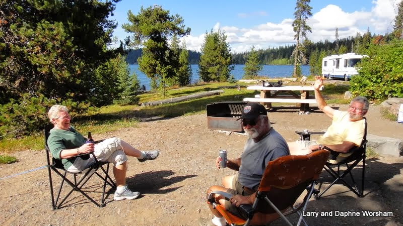
 Thursday 9/27 - We wanted to beat the predicted winds, so were on the road well before 8 AM - early for us! We had to battle our way through hoards of grasshoppers migrating across the highway, but we made good progress, arriving at our planned destination, Datil Well Campground, by about 2:30 in the afternoon.
 We've stayed at Datil Well before, though that was in the spring, so the landscape was a bit different. When we drove through New Mexico this spring we had remarked on how drought stricken everything looked, well, recent rains have remedied that situation. The same storm that caused such flood damage in Colorado also created flooding here in the Socoro area, though it wasn't so severe. That was about three weeks ago, and now there are wildflowers everywhere, and bugs hatching like crazy! The campground was crawling with black woolybear caterpillars. They were clinging to bushes, crawling up rocks, and in the chilly evening, they took refuge under our doormat and the boards we had used to level the trailer. We found them nestled down by the dozens when we picked up to move in the morning.
The wind did kick up as the weatherman had promised, and fortunately we were able to position the rig to block most of it so we could sit outside and enjoy the view. More wind expected on Friday, so we planned to be up and out early again.
Friday - Hitting the road early is easy when you haven't unhitched!
A quick breakfast and we were off.... and a good thing, as the winds didn't take long to move in. We planned another familiar stop for the night, Bottomless Lakes State Park.
The water in the lakes here is a lovely deep turquoise. The red cliffs, with their deeply eroded shadows, reflect in the water and when you toss in a few of the famous southwestern clouds, it's a scene hard to match.
It's a good place for taking walks, and Shiner loves to swim in Lea Lake, which is right at the edge of the campground. We took a nice long walk up the cliff at the south end of the campground, enjoying the large patches of wildflowers and the interesting rock formations, then went swimming in the lake in the afternoon. She's getting pretty good at fetching sticks out of the lake, actually picking up two at once on one occasion!

We planned a two day stop here, taking Saturday off to rest and to watch the Ducks game. It was a nice respite as two long days in the saddle, especially battling winds, get tiring.
Sunday we were on the road again, stopping at San Angelo State Park. There are only so many ways in and out of Texas, so these close in stops become repetitive. To change things up a little we stayed this time in the north campground, rather than the southern where we've stayed twice before.
 The park has a strange registration system. If there's no one at the gate or office you have to register at the entrance, filling out the form, including your campsite number, and dropping it in the "iron ranger". Well, how do you know the campsite number before you've picked it out? So off to the campground we go, a LONG way from the entrance, select our site and get set up, expecting to find a deposit box there too, as most other campgrounds have. Not so. With the hitch jack broken, all set up but the truck still attached to the trailer, and no money box in site, all we could do was wait for a ranger to drive by. We got it all worked out, and permission to just drop the pay envelope in the box on the way out in the morning. sheesh..... what an odd system.
Shiner had plenty of entertainment here, as a young kitten decided to try to adopt us. It was so very skinny, and obviously hungry, we just had to feed it.
 The poor little thing gobbled down quite a bit of milk and kibble, and seemed to be very interested in Shiner, but managed to stay just out of her reach. We would have adopted it if we had a way to care for it, but being gone half the year precludes cat ownership I'm afraid.
Monday - HOME!! Yeah! and, due to all the recent rain, we've got quite a jungle to deal with. Kendra does mow, but when it rains things really explode, so it's an annual routine for us. It doesn't take long to recuperate the greenery, which will explode again as soon as another rainstorm hits.
Three days of mowing and trimming have brought us pretty much up to acceptable levels, though there's always more to do. We'll be unpacking for a couple of weeks, then back to the home improvement projects. The fun never ends!
Stay tuned for further adventures!!
 Thursday 9/27 - We wanted to beat the predicted winds, so were on the road well before 8 AM - early for us! We had to battle our way through hoards of grasshoppers migrating across the highway, but we made good progress, arriving at our planned destination, Datil Well Campground, by about 2:30 in the afternoon.
The wind did kick up as the weatherman had promised, and fortunately we were able to position the rig to block most of it so we could sit outside and enjoy the view. More wind expected on Friday, so we planned to be up and out early again.
Friday - Hitting the road early is easy when you haven't unhitched!
 |
| View of Lea Lake campground from the cliffs |
The water in the lakes here is a lovely deep turquoise. The red cliffs, with their deeply eroded shadows, reflect in the water and when you toss in a few of the famous southwestern clouds, it's a scene hard to match.
It's a good place for taking walks, and Shiner loves to swim in Lea Lake, which is right at the edge of the campground. We took a nice long walk up the cliff at the south end of the campground, enjoying the large patches of wildflowers and the interesting rock formations, then went swimming in the lake in the afternoon. She's getting pretty good at fetching sticks out of the lake, actually picking up two at once on one occasion!

We planned a two day stop here, taking Saturday off to rest and to watch the Ducks game. It was a nice respite as two long days in the saddle, especially battling winds, get tiring.
Sunday we were on the road again, stopping at San Angelo State Park. There are only so many ways in and out of Texas, so these close in stops become repetitive. To change things up a little we stayed this time in the north campground, rather than the southern where we've stayed twice before.

Shiner had plenty of entertainment here, as a young kitten decided to try to adopt us. It was so very skinny, and obviously hungry, we just had to feed it.

Monday - HOME!! Yeah! and, due to all the recent rain, we've got quite a jungle to deal with. Kendra does mow, but when it rains things really explode, so it's an annual routine for us. It doesn't take long to recuperate the greenery, which will explode again as soon as another rainstorm hits.
Three days of mowing and trimming have brought us pretty much up to acceptable levels, though there's always more to do. We'll be unpacking for a couple of weeks, then back to the home improvement projects. The fun never ends!
Stay tuned for further adventures!!
Wednesday, September 25, 2013
Standin' on a corner, in Winslow Arizona. . .
 |
| Black Canyon, just east of Boulder Dam |
Homolovi State Park protects the remains of several Anasazi pueblos, and serves as a research center for the late migration period of the Hopi, from the 1200-1300s.
 |
| Homolovi II ruins |
There are pottery shards everywhere, left as they lie for visitors to admire. The variety of pottery styles that are seen among the shards is interesting.
The visitor's center is small, but has informative displays, and there are several trails to walk, one of which leads to a few small examples of rock art.

Walking up the gentle rise at the edge of camp in the evening we saw the lights of Winslow, sparkling like diamonds in the dusty twilight. At full-dark, those little diamonds moved to the sky. Surely there are more stars here than we've seen in a long time!
After touring the pueblo ruins we wandered into Winslow to see what we could see. The town has a couple of claims to fame. One is the mention of Winslow in the Eagles' famous song "Take it Easy".

There's even a mural and a bronze statue on main street to commemorate the song. That "girl in a flat bed Ford is featured in the mural, and she's lookin' pretty good! The building that the mural is painted on burned, but they managed to save the wall. Now, there's a park where the rest of the building once stood.
There's an annual music fest too, inspired by the band. This year's is coming up soon, on Sept. 27. The event website has details.

The hotel has been lovingly restored and is a real treat to visit. We had a delicious lunch in the hotel's Turquoise Room, and after lunch wandered the hotel admiring the historic furnishings, art, and garden spaces. Their gift shop offers beautiful Native American jewelery, as well as other handcrafted items, and we really enjoyed browsing.
 Last but not least, following the information on a little brochure I picked up at the Homolovi Park visitor's center, we found our way down to Winslow's First Street, where a very attractive little park has been built along the railroad tracks. Central to the park is a totem pole carved by Peter "Wolf" Toth. He has carved one in each of the 50 states (two in some states) and this was the location he chose for his work in Arizona. Photos of each of his carvings, as well as his life story, are in his book "Indian Giver".
The predicted winds had picked up during lunch, and by the time we reached camp it was a full gale. We settled down to take the afternoon off, huddling on the lee side of the trailer, watching the afternoon shadows lengthen. We plan an early departure so as to get out of the area before the strong winds kick up again.
The photo album has more shots of the area, and of the beautiful La Posada hotel.
Tuesday, September 24, 2013
Heading south
Well, the dentist in Klamath Falls couldn't find any cause for Steve's toothache, which makes in none the less painful, but, resulted in no treatment. So, we've decided the best approach is to head for home. That way if he needs to get to his regular dentist he can. I still don't feel much like sightseeing anyway, so we'll move along faster than usual, and if we both improve we'll slow down and take in whatever points of interest we happen to be near.... that's called shifting to "Plan B".
Shiner and I had taken several forays out into the woods while we were at Collier State Park. She did enjoy the opportunity to work on her leaping-like-a-deer-over-logs skills, and rooting for rodents,and wading in the river, so she got in her daily exercise. Our next stop, Ram Horn campground, in northeastern California.
Another of our favorite out of the way spots, the campground is usually empty or at least sparsely populated when we arrive. This time there were several vehicles and tents in occupancy. We pulled into the far end and managed to find a place that didn't require us to unhitch... we still have that broken jack to contend with. This is a very rustic campground.... no services and no supervision, so Shiner could run off leash. We explored the road in both directions, inspecting fresh deer tracks and evidence of horses as well as chipmunks and lizards. Shiner would dash up one side of the road, then back and down into the creek bed. I'm sure she traveled at least four times as far as I did in the same amount of time. It had rained recently so the ground was a bit soft, but fortunately we'd missed the muddy stage. We'd been quite a while on the road, and the weather had turned cold, so we tucked in early and prepared for a long day ahead.
Next stop, south on hwy. 395, Hawthorn, Nevada. Hawthorn is largely an Army depot that stores ammunition, not really what you'd call a tourist attraction. It does inspire creative stories however. Being "out in the middle of nowhere", as it is, makes for good story telling. One version version is based on the idea that the depot is really a secret, underground submarine base! A very 007 concept, don't you think!
Whiskey Flats RV Park was our destination, and it's a nice park, as such things go, with large grassy areas at the ends of the rows and across the front of the park. 'Very tidy, people are friendly, full service including a laundry room if you need one. The gentleman who checked us in was very clear..."NO dogs on the grass". OK, so we pull into our assigned space, which is a very narrow ribbon of concrete snuggled up to another rig, on their very own ribbon of concrete. As we've been assigned an end space our doors open onto a large patch of beautiful green grass, and in the middle of the grass is a sign..."NO dogs on the grass"! Shiner is quite young and has not yet learned to levitate, but we did the best we could, making her walk on only her front feet until we were on the gravel drive. She cast longing looks at the green patch, as she does love to roll on soft green grass, and really couldn't understand the restriction at all!
The park does have a dog area toward the front that is large enough to play ball, which we did, so all was not lost. We tried adventuring out into the desert, but the entire area is scattered with broken glass. I can't imagine how so many acres could be covered with the stuff, all colors, but none of the old sun-purpled glass, so it's not old. Some is sandblasted enough to be rounded on the edges, but much is still sharp, though in mostly very small bits. Very strange, but we worked our way around it and went back to playing in the dog area. A little exercise was enough for the day for all of us.
Back on the road, still heading south, we'd planned a long drive for the day. Traveling at our usual pace wouldn't get us home, and to that dentist, very quickly! We sailed through Nevada's back country, where traffic jams are unheard of, the sky is bright blue, and the vista's are colorful and varied. We never tire of admiring the multicolored, weather sculpted mountains. Evidence of mining activity, new and historic, dots the hillsides, and it's fun to located settlement names on the map, then try to find evidence they were ever in existance as we drive through the location. Lumber was always scarce in this part of the country, so any wooden structures were usually either moved to a new location when a mining town folded up, or have been since used as firewood. We often can see a bit of adobe ruins, if the town was older, or a little concrete foundation, but often even that has been overtaken by sagebrush.
Destination for Monday night, Boulder City Elks Lodge. This is one of our favorite places to stop, as far as city accommodations. (See this post for history of the lodge) We've been here twice before, most recently was two years ago, and the host and bartender remembered us! Such friendly folks, and the club is always having some sort of social gathering so there are always folks about to chat with, and we always find connections. This time we met a gentleman who grew up in El Monte, where I was born, then moved to Long Beach, where we both grew up. He was in the newspaper business, and both our fathers were (though he was in a different capacity). It is truly a small world!
The lodge RV area was pretty full, but we did find a space that, again, allowed us to park without unhitching. Steve had checked the Camping World in Henderson, on the way in, for a new hitch, but they didn't stock the one he wants, so we'll do without for awhile. He can probably fix the broken one when we get home, so it's just a matter of putting up with it until then.
One more long day ahead of us and then we'll take a break for a couple of days. Maybe by then my head will be clear enough to snap a few photos.
Friday, September 20, 2013
Final Duck game for us
I'm a little behind with updates here.... 'been under the weather with a head cold, so here's what we've been up to.
 We were back at Armitage Park for the Tennessee game. On Friday we drove up to Portland again to help Grayce bring her trailer down for the game, and this time she drove! Steve just rode shotgun, giving her tips and discussing concerns along the way, and she did a great job!! She's now an official trailer toten' Mama!
We had another "after the game" tailgate party at the campground, our last of the season as we'll be heading home. This time the menu included some great Mexican food - appropriately warming, as the weather had turned colder than any of us had expected.
Sunday we ran around like crazy getting chores and shopping done. We packed up quickly, then Monday morning we met up with John and Chris and caravaned south to Diamond Lake. We found really nice adjacent sites with lake views and settled in for an afternoon of visiting, relaxing, and just admiring the lake. The air was cool, but the sky was mostly clear, with just a few puffy clouds for decorative effect.
 Diamond Lake, and the so named peak, were named for John Diamond, an early settler in the area. I do love browsing the names on maps and wondering how a mountain, valley or creek got its name. So many historic figures have been immortalized as landscape features. It makes the area seem more alive to know a little more about who has gone before us.
In the evening Chris and John treated us to a fantastic dinner of lamb chops from their farm. The dogs both enjoyed a treat of our chop bones, and we all tucked in for the night with full tummies and pleasant thoughts of the beautiful surroundings and good times camping with friends.
Tuesday we woke up to cold, damp skies - winter weather is definitely on the way, so we weren't surprised. After breakfast we all loaded into the truck and took off for Crater Lake, only a few miles away.
John and Chris had never been to Crater Lake, so this was a new experience for them.
The blue sky had pretty much disappeared by this time, replaced by a cloud that looked like wet cotton settling down between the trees. Driving the perimeter of Crater Lake, the lovely old stone barricades that border the scenic pull-outs all appeared to be backed by something solid instead of the usual bright blue lake. As the clouds shifted here and there the monochrome landscape varied, still beautiful, though this time in shades of gray.
We toured the visitor's center and the lodge. The fog had pretty well dissipated by then, so the glowing blue tones of the lake were gradually revealing themselves. We took a quick tour of the gift shop, and when we came out the party-cloudy skies had turned into a snow storm!
 Things do change quickly in the mountains! Holding out hope in the weather forecast for Wednesday, only "partly cloudy" we headed back to camp, and a warm place to relax.
Wednesday we headed back up to Crater Lake, this time under sunny skies. The lake's famous brilliant blue and turquoise tones were on full display, an amazing contrast to the icy gray of the day before.
I never cease to be amazed at the brilliance of the colors here. The slopes around the lake, as well as the color of the water, are so amazing one would suspect the photos have been altered.... no need, it's an amazing landscape without any help!

Chris was interested in walking the trail down to the boat launch, so we headed around to that side of the lake. I only went part way, but she and John finished the 2 mile round trip. It's a really nice, well maintained trail, but quite steep, with more switchbacks than I could count....ranked "strenuous" on the list of trails in the park. There are some beautiful views from the higher levels, so I felt like I saw the best of it in the 1/3 of the trail that I traveled.
More photos in the album here.
Thursday we said adieu to our friends as they departed for a meet-up with other friends at the coast, and we start creeping our way toward Texas.
I'm feeling a bit brain dead with a bad head cold, and Steve developed a horrendous toothache, so we've scheduled a stop in Collier State Park (near our old stompin' grounds, Chiloquin) so he can hunt up a dentist. While he's in town he'll also be shopping for a new hitch jack, which broke while we were at Diamond Lake. There's always something to keep us on our toes!!!
 We were back at Armitage Park for the Tennessee game. On Friday we drove up to Portland again to help Grayce bring her trailer down for the game, and this time she drove! Steve just rode shotgun, giving her tips and discussing concerns along the way, and she did a great job!! She's now an official trailer toten' Mama!
We had another "after the game" tailgate party at the campground, our last of the season as we'll be heading home. This time the menu included some great Mexican food - appropriately warming, as the weather had turned colder than any of us had expected.
Sunday we ran around like crazy getting chores and shopping done. We packed up quickly, then Monday morning we met up with John and Chris and caravaned south to Diamond Lake. We found really nice adjacent sites with lake views and settled in for an afternoon of visiting, relaxing, and just admiring the lake. The air was cool, but the sky was mostly clear, with just a few puffy clouds for decorative effect.
In the evening Chris and John treated us to a fantastic dinner of lamb chops from their farm. The dogs both enjoyed a treat of our chop bones, and we all tucked in for the night with full tummies and pleasant thoughts of the beautiful surroundings and good times camping with friends.
Tuesday we woke up to cold, damp skies - winter weather is definitely on the way, so we weren't surprised. After breakfast we all loaded into the truck and took off for Crater Lake, only a few miles away.
 |
| Wizard Island in the fog |
The blue sky had pretty much disappeared by this time, replaced by a cloud that looked like wet cotton settling down between the trees. Driving the perimeter of Crater Lake, the lovely old stone barricades that border the scenic pull-outs all appeared to be backed by something solid instead of the usual bright blue lake. As the clouds shifted here and there the monochrome landscape varied, still beautiful, though this time in shades of gray.
 |
| Chris and John, and the invisible lake |
We toured the visitor's center and the lodge. The fog had pretty well dissipated by then, so the glowing blue tones of the lake were gradually revealing themselves. We took a quick tour of the gift shop, and when we came out the party-cloudy skies had turned into a snow storm!

Wednesday we headed back up to Crater Lake, this time under sunny skies. The lake's famous brilliant blue and turquoise tones were on full display, an amazing contrast to the icy gray of the day before.
I never cease to be amazed at the brilliance of the colors here. The slopes around the lake, as well as the color of the water, are so amazing one would suspect the photos have been altered.... no need, it's an amazing landscape without any help!

Chris was interested in walking the trail down to the boat launch, so we headed around to that side of the lake. I only went part way, but she and John finished the 2 mile round trip. It's a really nice, well maintained trail, but quite steep, with more switchbacks than I could count....ranked "strenuous" on the list of trails in the park. There are some beautiful views from the higher levels, so I felt like I saw the best of it in the 1/3 of the trail that I traveled.
 |
| Chris on the trail |
More photos in the album here.
Thursday we said adieu to our friends as they departed for a meet-up with other friends at the coast, and we start creeping our way toward Texas.
I'm feeling a bit brain dead with a bad head cold, and Steve developed a horrendous toothache, so we've scheduled a stop in Collier State Park (near our old stompin' grounds, Chiloquin) so he can hunt up a dentist. While he's in town he'll also be shopping for a new hitch jack, which broke while we were at Diamond Lake. There's always something to keep us on our toes!!!
Thursday, September 12, 2013
Blood and Thunder - a book review

This title was in the bookstore when we visited Bosque Redondo (see the post on that trip), so we purchased the Kindle version and have been reading it "on the trail", so to speak. What an amazing story, and so much of it buried or long forgotten. This is the kind of history we must not forget!
Though the famous mountain man Kit Carson is the central figure in this book, he is set in context, surrounded by many others who were so integral to the rapidly unfolding history of the time.
Stephen Watts Kearny, John Fremont, Henry Sibley, General James Henry Carleton, the Navajo warrior Narbona, and Senator Thomas Benton. Others, equally important but whose names are lesser known, rise to importance as the story unfolds. The conflicts with Mexico, the interactions between the various tribes, and the interests of the pioneers in their movement west, all play a part in the drama, and Sides does well at allowing the reader to understand each perspective.
 |
| Kit Carson |
A fascinating man who spoke many languages and understood the many Native American cultures he encountered, he also worked for the US Army, killing these same Indians and acting at the Army's direction in removing them from their homelands and onto dismal reservations.
 The author is as objective as one could be, I think, in describing the times, the reasoning behind the actions and plans, and weaving together the strands of politics, culture, the interactions of our government with Mexico, and western movement, over-layed with the strong personalities who played such important roles in the early history of our country.
I've read a lot of history set in this time period, but never have I encountered such a masterful collage of events and personalities.
 |
| Gen James Carleton |
A sad but fascinating tale, and one that is a must-read for anyone visiting the area, or interested at all in the impact of the policies growing out of the belief in Manifest Destiny.
A bonus for the true history buff, this book will lead to many others, as sources are not only sited, they are briefly analyzed in a notes section.
Sunday, September 8, 2013
Good times in Eugene
Back in the ol' stompin' grounds... Armitage Park, in Eugene, is our usual hangout for the beginning of the football season. This year we will not be tailgating at the stadium this year, so we have an alternate plan, two days of tailgating at Armitage! We partied in the park on Friday evening, took the bus in to the the stadium for the game, and followed up with another party on Saturday evening. Good times visiting with a lot of our friends, some who still live in the area and others who have come from other states for the game.

We didn't have high expectations for excitement during this first game, as the school we played wasn't much of a challenge, but the crowed showed up in full Duck regalia.
Worthy of note is the new Duck Football Performance Center, which one columnist described as "looking like something out of a George Lucas movie", and indeed it does. From Martin Luther King Blvd. it appears to float in space, a little like the Death Star in Star Wars.
 In the patio between the facility and the bookstore, however, it becomes a serene space reminiscent of a meditation garden, until all the fans show up that is! The entire complex, consisting of several buildings from previous expansions, has been clad in new materials, most are now flat black to coordinate with the new center, giving the complex a rather intimidating presence. We had limited opportunity for photography but there is a great slide show here that has some wonderful shots of the interior.
We know the area so well that it's very convenient to shop here.... also - no sales tax and because we know where all the stores are. So, between the long lists we've been compiling and the basics of groceries and other housekeeping stuff, we've kept pretty busy running here and there and then trying to figure out how to fit it all into the already crowded RV.
We rewarded ourselves for a day of hard work over the shopping lists with a dinner out at the new Wild Duck Cafe on Coburg. The downtown restaurant, across from Matt Court, is still there, so this is a brand new venture. The interior has been turned into a gallery for the artistic talents of the crew at Metal Zen, a local company. Ducks sail around the room, acting as dividers between two small sections of the restaurant, while below them cattails reflect the soft lighting. Very attractive, but not overdone or distracting.
 Attracted to the large wooden sculpture of Sasquatch in the room adjoining our dining room I started talking with one of the wait staff and learned some amazing details.
The figure is carved in the likeness of Glen Falconer, who was the first brewmaster with the Wild Duck brewery in the old days, when they were located on 6th Street downtown. The bigger than life Sasquatch guards what will be the entrance to the bar and possible brewery. The football helmet on his upraised fist conceals a bottle with the Wild Ducky label.

Glen was much beloved by his friends and coworkers and there is an annual Sasquatch beer fest now held in his memory. You can read more about him at the website of a foundation formed to further his interests in brewing. They offer scholarships and support the Sasquatch beer fest, among other activities.
The atmosphere in this new cafe is comfortable, and seems quieter than when it was occupied by BJ's (which has now moved over to VRC). The menu is expanded from the cafe down by the university, and seems a few steps above the average pub food. We'll definitely be back to try out other items on the menu!
We're going to lie low for the next few days and visit some old friends, waiting for the next home game!

We didn't have high expectations for excitement during this first game, as the school we played wasn't much of a challenge, but the crowed showed up in full Duck regalia.
Worthy of note is the new Duck Football Performance Center, which one columnist described as "looking like something out of a George Lucas movie", and indeed it does. From Martin Luther King Blvd. it appears to float in space, a little like the Death Star in Star Wars.

We know the area so well that it's very convenient to shop here.... also - no sales tax and because we know where all the stores are. So, between the long lists we've been compiling and the basics of groceries and other housekeeping stuff, we've kept pretty busy running here and there and then trying to figure out how to fit it all into the already crowded RV.
We rewarded ourselves for a day of hard work over the shopping lists with a dinner out at the new Wild Duck Cafe on Coburg. The downtown restaurant, across from Matt Court, is still there, so this is a brand new venture. The interior has been turned into a gallery for the artistic talents of the crew at Metal Zen, a local company. Ducks sail around the room, acting as dividers between two small sections of the restaurant, while below them cattails reflect the soft lighting. Very attractive, but not overdone or distracting.

The figure is carved in the likeness of Glen Falconer, who was the first brewmaster with the Wild Duck brewery in the old days, when they were located on 6th Street downtown. The bigger than life Sasquatch guards what will be the entrance to the bar and possible brewery. The football helmet on his upraised fist conceals a bottle with the Wild Ducky label.

Glen was much beloved by his friends and coworkers and there is an annual Sasquatch beer fest now held in his memory. You can read more about him at the website of a foundation formed to further his interests in brewing. They offer scholarships and support the Sasquatch beer fest, among other activities.
The atmosphere in this new cafe is comfortable, and seems quieter than when it was occupied by BJ's (which has now moved over to VRC). The menu is expanded from the cafe down by the university, and seems a few steps above the average pub food. We'll definitely be back to try out other items on the menu!
We're going to lie low for the next few days and visit some old friends, waiting for the next home game!
Thursday, August 29, 2013
North Davis Creek, 2013
North Davis Creek campground

What a difference a year can make. Looking back at our notes (see that post here), we stayed here at North Davis Creek on exactly the same dates in 2012. There is a noticeable difference in the water level in the lake portion, though the creek is still as boisterous as ever. I've put comparison photos in the album, to illustrate the difference.
 North Davis Creek campground is northeast of Davis lake, on the east side of highway 46, and actually feeds into a small arm on the west edge of Wickiup Reservoir. A bit of history here: The name Davis is taken from "Button" Davis, a nineteenth century stockman from the Prineville area who ran cattle in the vicinity of the lake. Davis Mountain, rising above the lake on the east side, was presumably named for the same man. In 1878 the name was already in use when Lt. T.W. Symons visited the area. His survey report included the first known description of the area, so this area has been well known for a long time, but it seems to have a lot less traffic that other lakes and other campgrounds in the general area, so we enjoy it for its quiet and natural beauty, and lack of traffic and crowds.
What a beautiful campground! Several of the sites back up to the creeks, but site 7, the beach view site we stayed in last year, was available when we arrive, so who could resist? Arriving on Thursday we had the campground to ourselves until Saturday, when several sites were occupied. The place emptied out again on Sunday, so Monday and Tuesday morning were quiet, leaving only the occasional drive-through visitor to chat with.
I think it's safe to say that Shiner LOVES this campground. We forded the creek toward the east on Friday and explored the shore opposite our site. The shore, exposed now due to the low water, is soft silt, muddy in places, and the forest higher up on the shore is almost too dense to walk through...unless you are a deer at any rate. The only trails are made by the wildlife, so it's tricky to explore, but fun to see a view of things from across the water.
On Monday we went up to the headwaters of North Davis Creek. Just above site #12 there is a sign identifying the location, though the trees crowd in so closely now that the sign is hard to find. The headwaters is a rough pile of basalt with crystal clear water gushing from its base. Oozing between piles of moss and fallen logs the water builds speed as it is joined by multiple little streams along the way.
We walked across the basalt flow to get to the other side of the creek, and then tried out several of the many little log bridge routes.
There are at least 3 log bridges (depending on how generous your definition is); one between sites 10 and 11, a zigzag of three logs across the mouth of the little lagoon to the north shore, and the one connecting the campground to the shore near the lagoon at site 9. Shiner tried wading as well as actually walking on the logs, and is pretty good at both methods. Anything that leads to an adventure appeals to her!
Some ambitious exploration will reveal several outcrops of basalt, all sheltering water flows. Layers of moss, who knows how many generations deep, surround the quiet lagoon that has formed off to the north of the creek.
You can walk on the moss and hear water running, but only see it in the occasional holes in the mossy forest floor that reveal you are actually walking on water!
If landscape can be "photogenic" this location definitely is. I know I took way too many photos of the creek, and of Shiner playing in it. She was having so much fun exploring it was tempting to try to capture all of her adventures, but she moves way too fast!!
The most abundant wildlife here is, no surprise, the golden mantle squirrel (chipmunk to most of us). These are Shiner's primary irritant as they know when she's on a leash and sit just out of reach, chattering at her. I guess you could consider it dog TV as it does keep her entertained.
Farther afield, across the creek, we spotted several deer and some very healthy looking coyotes (full of chipmunks no doubt). They never show up when the camera or binoculars are handy of course, so we just enjoyed watching them.
 The days here were fairly warm and comfortable, but a couple of thunderstorms did their best to make it feel as though fall is already here, rather than just approaching. The second storm was complete with some fairly substantial hail. We didn't see any smoke on the horizon following either storm, a good thing, as there are already way too many fires burning in the state. Each night was a bit colder than the previous, with our last night here dipping down to 36 degrees. Yes, fall is definitely on the way.
More photos of our adventure here.
We're packing up on Tuesday morning and heading for Armitage Park in Eugene, to get things "civilized" and attend the first Duck football game of the season.... GOOOOOOO Ducks!!

What a difference a year can make. Looking back at our notes (see that post here), we stayed here at North Davis Creek on exactly the same dates in 2012. There is a noticeable difference in the water level in the lake portion, though the creek is still as boisterous as ever. I've put comparison photos in the album, to illustrate the difference.
 North Davis Creek campground is northeast of Davis lake, on the east side of highway 46, and actually feeds into a small arm on the west edge of Wickiup Reservoir. A bit of history here: The name Davis is taken from "Button" Davis, a nineteenth century stockman from the Prineville area who ran cattle in the vicinity of the lake. Davis Mountain, rising above the lake on the east side, was presumably named for the same man. In 1878 the name was already in use when Lt. T.W. Symons visited the area. His survey report included the first known description of the area, so this area has been well known for a long time, but it seems to have a lot less traffic that other lakes and other campgrounds in the general area, so we enjoy it for its quiet and natural beauty, and lack of traffic and crowds.
What a beautiful campground! Several of the sites back up to the creeks, but site 7, the beach view site we stayed in last year, was available when we arrive, so who could resist? Arriving on Thursday we had the campground to ourselves until Saturday, when several sites were occupied. The place emptied out again on Sunday, so Monday and Tuesday morning were quiet, leaving only the occasional drive-through visitor to chat with.
 |
| Our campsite from the opposite bank |
I think it's safe to say that Shiner LOVES this campground. We forded the creek toward the east on Friday and explored the shore opposite our site. The shore, exposed now due to the low water, is soft silt, muddy in places, and the forest higher up on the shore is almost too dense to walk through...unless you are a deer at any rate. The only trails are made by the wildlife, so it's tricky to explore, but fun to see a view of things from across the water.
 |
| Investigating the source of the creek |
We walked across the basalt flow to get to the other side of the creek, and then tried out several of the many little log bridge routes.
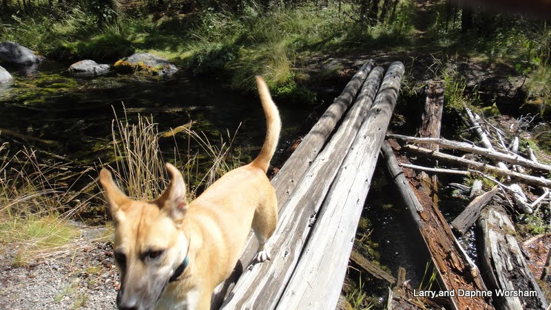 |
| Flying across the bridge |
There are at least 3 log bridges (depending on how generous your definition is); one between sites 10 and 11, a zigzag of three logs across the mouth of the little lagoon to the north shore, and the one connecting the campground to the shore near the lagoon at site 9. Shiner tried wading as well as actually walking on the logs, and is pretty good at both methods. Anything that leads to an adventure appeals to her!
Some ambitious exploration will reveal several outcrops of basalt, all sheltering water flows. Layers of moss, who knows how many generations deep, surround the quiet lagoon that has formed off to the north of the creek.
 |
| Sky and clouds reflected in the water underneath the moss |
If landscape can be "photogenic" this location definitely is. I know I took way too many photos of the creek, and of Shiner playing in it. She was having so much fun exploring it was tempting to try to capture all of her adventures, but she moves way too fast!!
The most abundant wildlife here is, no surprise, the golden mantle squirrel (chipmunk to most of us). These are Shiner's primary irritant as they know when she's on a leash and sit just out of reach, chattering at her. I guess you could consider it dog TV as it does keep her entertained.
Farther afield, across the creek, we spotted several deer and some very healthy looking coyotes (full of chipmunks no doubt). They never show up when the camera or binoculars are handy of course, so we just enjoyed watching them.

More photos of our adventure here.
We're packing up on Tuesday morning and heading for Armitage Park in Eugene, to get things "civilized" and attend the first Duck football game of the season.... GOOOOOOO Ducks!!
Thursday, August 22, 2013
Tailgate Trainging Camp 2013
 We've held training camp at Ochoco Forest Campground for several years now, and it's quite a distance from the Willamette Valley, so we stopped one night on the way, at Cold Springs campground. This is a nice place to work back into the boondocks mode.
The area is fairly open, with pines and a few shrubs, and a little creek running through the campground. It was very quiet as there were only a few other sites occupied. Shiner did her best to rid the area of chipmunks and other varmints, but I don't think she was very successful.
Friday morning we left Cold Springs and moved on to Training Camp.

We had several new attendees this year.


There was a heavy sports schedule this year at camp.
 Dave and Evie tried out her new bow, there were a few games of horseshoes and bolo toss, and some of us went for the annual walk around Walton Lake. It's small, but very pretty. The meadow that's usually covered with wildflowers and butterflies was drier this year, so though there were a few butterflies enjoying the wild asters, most of the wildflowers were in short supply.
 We came home with a special treat this year. John made several bird houses and feeders for those who came to camp, and we were lucky enough to have this one, complete with a little piggy.

The detail John puts into these creations is amazing, right down to the little handmade ax stuck in the little stump on the porch.
It was a great four days - good food and good friends is a combination hard to beat! For a few more shots of the camp and all the fun we had, check the album.
Saturday, August 17, 2013
Barton Park and Champoeg State Park, Oregon
We have to work ourselves into the urban environment slowly, so as to not cause too much of a shock to the system, so when approaching the Portland area we took even smaller steps than usual.
First, a couple of nights at Barton Park, east of Oregon City, on hwy. 224. This is a Clackamas County park. The park has 102 sites in addition to day use facilities and lots of parking for river access. Everything is very nicely maintained, though they've left quite a bit of unmowed area around the little ponds. That works out well for the wildlife.
The ponds are a bit swampy covered with algae and duckweed they look greener than the grassy areas, but they do attract the wildlife. Our first evening in the campground a big fat beaver waddled up out of the creek, across the grass and down into the pond. Shiner stared in amazement as she didn't quite know what to think of the critter.
This park was a unique experience, as we don't often stay in such an urban environment. Most of the campers live within an hour's drive from the park. They just wanted to "get away for the weekend", and often come in two and three family groups.
 The evening had a happy sound, as children rode their bikes and skateboards, played volleyball and other games, and the adults visited and played horseshoes.
Beautiful weather added to the enjoyment, as did the colorful sunset. The second evening we had a bit of rain, and a full rainbow....at 8:15 in the evening! That doesn't happen often!
 Moving west, to the middle of the Willamette Valley, we stayed at Champoeg State Park, convenient for our friend Grayce to drive down from Portland for a visit, and for us to drive up there for a great BBQ.
We've used Champoeg before as a base for the Portland area. We stayed here in 2010, right after I retired. Here's the album from that trip.
It's a great place for us, as there are plenty of places to walk Shiner, and the park has a fascinating history. We even found a Nez Perce connection here, with the trail-side grave marker of Kitty Newell, the Native American wife of one of the pioneers who settled here.
Trails wander among markers indicating the location of various buildings before they were all lost to flooding, and the volunteers do a marvelous job of maintaining the historic kitchen gardens around the visitor center, as well as sharing their knowledge of the history of the time. The gift shop is stocked with a variety of hand made and history related items, especially books. They had some great northwest related children's books, and the gardeners have made available packaged seed from heirloom varieties grown in the garden here.
 We had a great time visiting with Grayce and the family, first, a back yard bbq at Grayce's house, and then an afternoon out at the campground.
Now we head back to eastern Oregon, to Ochoco Forest Camp, for Tailgate Training Camp. We'll be out of touch, electronically speaking, for awhile as it's a fairly remote area.
First, a couple of nights at Barton Park, east of Oregon City, on hwy. 224. This is a Clackamas County park. The park has 102 sites in addition to day use facilities and lots of parking for river access. Everything is very nicely maintained, though they've left quite a bit of unmowed area around the little ponds. That works out well for the wildlife.
The ponds are a bit swampy covered with algae and duckweed they look greener than the grassy areas, but they do attract the wildlife. Our first evening in the campground a big fat beaver waddled up out of the creek, across the grass and down into the pond. Shiner stared in amazement as she didn't quite know what to think of the critter.
This park was a unique experience, as we don't often stay in such an urban environment. Most of the campers live within an hour's drive from the park. They just wanted to "get away for the weekend", and often come in two and three family groups.
 The evening had a happy sound, as children rode their bikes and skateboards, played volleyball and other games, and the adults visited and played horseshoes.
Beautiful weather added to the enjoyment, as did the colorful sunset. The second evening we had a bit of rain, and a full rainbow....at 8:15 in the evening! That doesn't happen often!
 Moving west, to the middle of the Willamette Valley, we stayed at Champoeg State Park, convenient for our friend Grayce to drive down from Portland for a visit, and for us to drive up there for a great BBQ.
We've used Champoeg before as a base for the Portland area. We stayed here in 2010, right after I retired. Here's the album from that trip.
It's a great place for us, as there are plenty of places to walk Shiner, and the park has a fascinating history. We even found a Nez Perce connection here, with the trail-side grave marker of Kitty Newell, the Native American wife of one of the pioneers who settled here.
Trails wander among markers indicating the location of various buildings before they were all lost to flooding, and the volunteers do a marvelous job of maintaining the historic kitchen gardens around the visitor center, as well as sharing their knowledge of the history of the time. The gift shop is stocked with a variety of hand made and history related items, especially books. They had some great northwest related children's books, and the gardeners have made available packaged seed from heirloom varieties grown in the garden here.

Now we head back to eastern Oregon, to Ochoco Forest Camp, for Tailgate Training Camp. We'll be out of touch, electronically speaking, for awhile as it's a fairly remote area.
Wednesday, August 14, 2013
Around Mt. Hood, Oregon
Heading back to Hood River, then south on the Hood River Scenic Highway (hwy. 35), as we traveled around a corner Mt. Hood suddenly came into view. Wow! what a site.....
 This is a beautiful part of the state. The road is lined with prosperous looking farms, fruit orchards and fruit packing plants. This time of year the trees are heavy with ripe pears, and a few wildflowers here and there for color.
It was only a short drive down the highway to a gem of a county park that Steve discovered using one of his favorite resources USCampgroundsInfo.com
Tollbridge Park is operated by Hood River County, and it's definitely going on our "A" list! (We didn't have one, but I think we'll start one now!) If we had known this park was here we never would have stopped at Memaloose.
The park has basically four loops. One for tents, one for full hookups (no tents allowed), two for partial hookups where tents are allowed - 85 sites in all, not counting the group sites. As the park takes reservations we could see that many sites were already spoken for, but we'd only planned two nights so we were able to snag one of the five river-side sites. All the river side sites are named for Oregon rivers, rather than having the usual numbers, and ours was "Crooked".
 The sites are all carved out of the dense, mixed forest so, at least in the loop we stayed in, they are fairly private. The campground map indicates a trail along the river, and though there are trails back to the river in several places, the trail along the river is rather sketchy and overgrown in areas. In some sections even Shiner had trouble deciding which rabbit trail was the one to follow!
 Our river access was a bit steep, but we found several nice, sandy locations out at the edge of the park where Shiner could play in the water and she had a ball! She'll rescue drowning logs as long as someone will toss them into the water for her.
She does prefer the larger ones though, if a stick is too small to suit her she'll rescue it, then park it on a little island in the middle of the river and wait for us to throw something larger and more worthy of her attention.
 We really enjoyed our hikes down to the river. The forest here is an interesting mix of fir, pine, big leaf and vine maple, ferns, wild roses and a myriad of other shrubs, all sprouting from between volcanic boulders and lovely beach sand.
Most of the underbrush is ferns and typical forest shrubs, but one sunny, sandy patch along the trail was filled with heat-loving manzanita bushes, a surprising contrast to the brilliant blue Oregon grapes glowing in the shade only a few yards away.
 We took a short drive on our second day over to the little town of Parkdale and stopped in McIsaacs's market. They have anything you'd need, including some nice looking local produce and a full line of craft beers.
We had a wonderful, relaxing time here, watching the river slide by, admiring the forest and listening to the rushing water. 'A vast improvement over the trains and traffic noise we've had in many campgrounds. For families with small children, the picnic area at the entrance to the park has a nice playground, so there's something here for everyone! You can find the park on Facebook too.

It was only a short drive down the highway to a gem of a county park that Steve discovered using one of his favorite resources USCampgroundsInfo.com
Tollbridge Park is operated by Hood River County, and it's definitely going on our "A" list! (We didn't have one, but I think we'll start one now!) If we had known this park was here we never would have stopped at Memaloose.
The park has basically four loops. One for tents, one for full hookups (no tents allowed), two for partial hookups where tents are allowed - 85 sites in all, not counting the group sites. As the park takes reservations we could see that many sites were already spoken for, but we'd only planned two nights so we were able to snag one of the five river-side sites. All the river side sites are named for Oregon rivers, rather than having the usual numbers, and ours was "Crooked".
 The sites are all carved out of the dense, mixed forest so, at least in the loop we stayed in, they are fairly private. The campground map indicates a trail along the river, and though there are trails back to the river in several places, the trail along the river is rather sketchy and overgrown in areas. In some sections even Shiner had trouble deciding which rabbit trail was the one to follow!
 Our river access was a bit steep, but we found several nice, sandy locations out at the edge of the park where Shiner could play in the water and she had a ball! She'll rescue drowning logs as long as someone will toss them into the water for her.
She does prefer the larger ones though, if a stick is too small to suit her she'll rescue it, then park it on a little island in the middle of the river and wait for us to throw something larger and more worthy of her attention.

Most of the underbrush is ferns and typical forest shrubs, but one sunny, sandy patch along the trail was filled with heat-loving manzanita bushes, a surprising contrast to the brilliant blue Oregon grapes glowing in the shade only a few yards away.
 We took a short drive on our second day over to the little town of Parkdale and stopped in McIsaacs's market. They have anything you'd need, including some nice looking local produce and a full line of craft beers.
 We had a wonderful, relaxing time here, watching the river slide by, admiring the forest and listening to the rushing water. 'A vast improvement over the trains and traffic noise we've had in many campgrounds. For families with small children, the picnic area at the entrance to the park has a nice playground, so there's something here for everyone! You can find the park on Facebook too.
Sunday, August 11, 2013
Traveling the Columbia Gorge
 |
| Making French fries, in the SAGE center |

Our stop for two nights - Memaloose State Park, Oregon
Entry into this park is a little unusual, as you pull off the freeway, travel through the day use/rest area, then make a right down into the campground.
Compared to our previous stop, this campground is looking a bit parched, which seems funny as it's right on the Colombia river. It's a much larger campground (well over 100 sites) and according to the park website they're having problems with the irrigation pump.
Some of the sites are a little on the crowded side, but as the water-only sites didn't all fill up we had a bit of breathing room. The sites with services are pretty much all reserved every night, so if hook-ups are desired, a reservation is definately recommended. There's no official hiking trail, but leading from the grassy slope down by the railroad tracks is a trail that leads east, parallel to the river and the tracks. The trains haven't bothered us at night, though we do hear them during the day. It's fascinating to watch the numbers of cars as they go by on both sides of the river and meditate on how many goods are moved by rail.

Though our site wasn't a "river view" site, we did have a pretty good view of it, and nestled under a couple of big old weeping willows we had plenty of shade. From our vantage point under the willows we had a nice view of two little islands out in the middle river.
Steve noticed what appeared to be some kind of monument on one of them. We finally found a signboard explaining the significance of the monument, and the island itself. The Chinook Indian tribes of the Columbia Gorge used to lay the bones of their dead on open pyres on Memaloose Island, the largest of the two. The granite monument marks the resting place where a local pioneer named Victor Trevitt wished to be buried. There are apparently several islands in the area known as Memaloose because of this tradition. More about them here.
 |
| Memaloose Island |
There are large blackberry patches around the edges of the campsites but due to the dry spring weather most of the berries are small, hard, and not very sweet. We did find a nice patch over by the over-flow camping area, where I filled three small bags while Steve and Shiner played ball. On the way back to our campsite we discovered an overgrown orchard of plums - three kinds! I think this must have been a farm at one time, as these trees look like seedlings and very overgrown old trees all tangled together. A woman we talked to said she believed this area had been some kind of traveler's stop in the old days - an inn or something of the sort perhaps.
One disadvantage of this park location is that it sits in between two widely spaced freeway access ramps. In other words, you have to go clear down to Hood River to get turned around to go back up-river to The Dalles. So we did. And, in the meantime, did a bit of shopping in Hood River, which has all the grocery stores, etc. one could want. Then, heading back east to The Dalles, we fueled up, then turned around and headed back west to hit a museum we'd seen coming in.
 |
| Pioneer days, at the Discovery Center |
Beginning with the Ice Age exhibits tell the of the hstory and ecology of this area as well as the people who have lived here.
 |
| Ice Age, in the Discovery Center |
Visitors learn about frontier life, the role of the missionaries and Native Americans, the railway, and more. Along one side of the building is the "Kids Room" with hands-on activities. There are also kid-friendly opportunities throughout the exhibits, with items to handle or try on. The center is huge, and a family could easily spend most of the day here. It's a good thing there's a cafe too. They've thought of everything!
From Memaloose we'll be leaving the Gorge and heading toward Mt. Hood.
Subscribe to:
Posts (Atom)