Wednesday, June 15, 2011

City of Rocks State Park, NM

We arrived in the City of Rocks State Park early in the afternoon on Monday. Approaching the park the formations look strangely like Stonehenge, only we're not in Britain, we're in New Mexico!

We'll be staying here for the next three days as we take in a bit of the surrounding area and recoup. After all, it was almost a 50 mile drive to get here!

This is a unique area geologically speaking. Formed of compressed volcanic ash that has metamorphosed into stone, then eroded over thousands of years, the formations resemble those in the Alabama Hills in California. Those formations are largely composed of granite however, so aren't counted among the six places in the world that have a feature like this.

We opted again for one of the few sites with power so we could safely leave Molly in the rig when we are out for the day. The electrical sites here are really nicely laid out. They're long, wide, nicely landscaped, and each has a small permanent shade over the picnic table which is sitting on a concrete pad (we could really have used that kind of setup in the Oregon rain!)

This mural includes 20 species who live in the area. 
It was in the high 90's when we first  arrived, so we took advantage of the cool interior of the visitor's center, admiring the murals and chatting with the host. Turns out we had met him last year at Rock Hound State Park. When we commented on the smoke in the air the host said this was really very moderate smoke, as a few days before there was a fire closer by and they had all been packed and ready to evacuate if necessary. 'Glad we missed that episode!

A quick drive around the perimeter of the campground gave us a better sense of the layout.
They have done a beautiful job of tucking campsites up in the rocks, providing privacy and a bit of shelter from both sun and wind for each of them. Each site has a picnic table situated on a perfectly level gravel pad, terraced with local stone.We noted this type of construction in other parks in the area. It's a really nice way to organize the sites without getting in the way of parking your RV, and helps slow down erosion.

The soil here seems to support a much wider variety of plant life than we saw in the Alabama Hills, and judging from all the last-year's yucca blossom stalks it must be breathtaking at the peak of spring bloom.
There is a Botanic Garden featured in the campground. It's well laid out, and does have a nice variety of species, but as a gardener, I must say it could use some loving attention. Overall the park does have a nice variety of vegetation and many of the yucca are in full bloom. There are a few stray wildflowers here and there, and many types of cactus have fruit that are starting to ripen.


There is also a really unique aspect to this park. It has an observatory.  The Simon Observatory is located in the group camp area, surrounded by picnic tables in alcoves formed by the rocks. there are also several placards describing various astronomical features. The solar system and space theme has been carried out in several ways around the park. There's a "campground scale" replica of the solar system, which starts out with a little garden with placards just behind the visitor center (oriented as if it were the sun) and then extends into the campground, and each of the sites has a name taken from the celestial systems. We're staying in Zena, for example (it's the 10th planet, now known as Eris.) Each site has a name taken from astronomy.
As evening approached the smoke in the air became even more obvious. As much as we've complained about the smoke, it does make for a colorful evening sky, a nice backdrop for all the yucca flowers and interesting rock formations. We're up over 5,000 feet, so the evening cools off quickly.We very much enjoyed sitting outside and watching the changing shadows as the jackrabbits and cottontails grazed around us.

We'll explore further tomorrow, as well as visiting the Gila Cliff Dwellings.  For a few more shots of the area visit the album.

Tuesday, June 14, 2011

Olive Lee Memorial State Park, NM

Sunday - We're making a quick overnight stop at Oliver Lee Memorial State Park, just south of Alamogordo. The park is billed as an oasis, where water flows year round and ferns flourish. But not this year. We can tell by the flower stalks and other vegetation that this area must be really luxurious in normal years, especially in the spring, but with the current drought conditions this year the plant life is struggling. Also unavoidable now - the vista that would typically be crystal clear is today clouded with smoke, blown in from one or more of the fires around the state. It does make for an interesting sunset photo though, so we make use of whatever advantage we can. That rosy glow makes a nice contrast to the lacy mesquite leaves. They're one of the few plants that have survived seemingly unscathed. But as we Texans know, you really can't kill a mesquite, no matter how hard you try!

This area was hit really  hard by the extreme winter, and now the drought is taking its toll. The main trail, up Dog Canyon, is closed as it leads into the Lincoln National Forest, which is closed. The campsites here are snuggled up against the foothills - interestingly eroded, they are tall enough to block the sun until later in the day than one might expect. Because of the slope almost every site has a fantastic views of the Tularosa Valley, and at night the lights in the houses scattered throughout the valley twinkle like stars. The sites are spacious, and graveled paths wander among the yucca and mesquite.

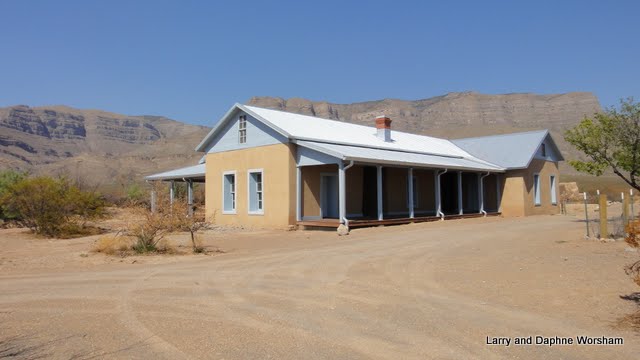
The visitors' center is small, and gives a brief overview of the area and the wildlife. The main feature of the park is the restored ranch house of Oliver Lee, a rather noteworthy figure in New Mexico's history. You can read about his encounter (as a murder suspect) with Sheriff Pat Garrett here and  here in a True West Magazine story. They don't make a lot out of this particular bit of history in the park, but to us the story of Lee's involvement with Pat Garrett and a never-solved murder mystery was what made the ranch really interesting to us. Take time to read about the case - it's a fascinating piece of western history!

We were the only people who showed up for the three o'clock tour of the Lee Oliver Ranch (the 100 degrees outside may have had something to do with it) But Wendy, the park manager, gamely saddled up and gave us a private tour. It was nice to be able to talk about the history of the ranch, recent as well as past, in a little more detail than usually happens in a crowd.

The wall was constructed for the movie.
The Ranch was used, with many alterations, as a set for the filming of  Scandalous John, a movie produced by Disney in 1971. There is a display in the ranch house featuring several photos from the filming of the movie. That event was particularly useful in restoring the building as it helped the researchers in identifying what was new and what was original in the structure.

As we were preparing to leave the park I glanced at a cholla cactus beside the road and noted what has to be a classic example of wildlife triumphing over human interference. (In other words, they can completely ignore us!) Note the nest in the cactus.... this was right at the edge of the road...... with three eggs in it!

Monday 8:30 AM - up and out early - for us! and heading for the White Sands visitor center. The visitors' center is in a 1920's adobe building - beautiful, and cool! Their gift shop is stocked with a nice array of Native American arts, and the information center has a great selection of books for adults as well as a wide variety of books and activities for children.
We picked up a great slow-cooker cookbook: Southwest Slow Cooking by Tammy Biber and Theresa Howel  - can't wait to try out some of the recipes! The displays in place are currently "place holders" as they are in the process of installing new state-of-the art displays. We'll have to catch those the next time we're passing  through.

Check the album for a few more photos.

Saturday, June 11, 2011

Three Rivers Petroglyphs site

We arrived at Three Rivers Petroglyphs site in the early afternoon on Friday. We had a bit of a jolt when we saw a sign saying "Three Rivers Petroglyphs campground closed" then realized it was referring to  the Three Rivers Recreation Area, not the petroglyph site.We have a new host and hostess this year. Nice folks, and after a brief visit we set up camp in the same spot we had last year. Steve checked his calendar and we were here on exactly the same date! Actually there aren't a lot of decisions to make about "which space" as there are only two with services. In this kind of weather having the electricity to run the air conditioner is nice, and the fee is only $10 a night. Hard to beat!

Everything looks pretty much the same except for the effects of the extremely cold weather ( 18 below!) and the drought.  Compare a creosote bush from last year, and the same one this year. The shots were taken from a slightly different angle but believe me it is the same bush!


We've spent many years wandering the desert and we've never seen creosote shrubs look this dry. It isn't hard to imagine what would happen with one little spark landing on vegetation this dry.

Knowing we were headed for temperatures in the high nineties we got an early start on Saturday morning. They open the gate to the trail at 8 AM, so we were there shortly thereafter. No dogs are allowed on the trail, so Molly had a nice, air conditioned nap while we hiked in the sun. What's that about a dog's life? We pretty much had the trail to ourselves, not surprising this time of year, though we have seen several cars come and go in the parking lot. It seems few venture far on the trail before they decide to head back for shade and water.

We pretty well explored the hills closest to the campground last year (read  last year's blog entry for more on the campground and pics of the petroglyphs), so this year we are focusing on those farther out, past the shaded rest area.

This is truly a treasure house for petroglyph enthusiasts. The trails are easy to follow in most cases, though you have to be a bit of a mountain goat to get to some of the best glyphs. The area near the beginning of the trail has a few numbers posted and there's a little guide book that explains a little about each figure. Farther out, where we went today, you're on your own. Of course, it's all open to individual interpretation anyway. Von Daniken would probably say they were left by space visitors, Levan Martineau  would explain the meaning of each panel as if he were reading a newspaper, James Keyser would toss in the concept of recording dreams and tribal history, then of course there's always the theory proposed by one of our neighboring campers, "it's just graffiti."   Whatever your view, it's clear from the various stages of patina development on older glyphs that this area was used for many generations so the area held some specific importance for a lot of people over time. It's about four miles, round trip, from the beginning of the trail to the farthest peak. And aside from the petroglyphs, you have a great view of the surrounding countryside.

We did our best to cover the largest area today, leaving two other outcrops to visit in the future. Here's the album of some of the best of what we saw today (click on the photo).